V
VGSMC_8520
Guest
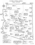
Here's something I made a while ago for my own personal reference, and wanted to share with everyone here too. Feel free to use, re-distribute, print off 100 copies and scribble all over them, whatever. Also, point out any errors, please.

High resolution 600 dpi 8.5 x 11 jpg here
data sources: Openstreetmap, RadioReference.com
I don't have DPS district polygon data, but maybe I'll draw those and swap the county boundaries out in the future.
High resolution 600 dpi 8.5 x 11 jpg here
data sources: Openstreetmap, RadioReference.com
I don't have DPS district polygon data, but maybe I'll draw those and swap the county boundaries out in the future.
Last edited: