Fire in Hills above Azusa

Status
Not open for further replies.

Delldell26

Member
Joined
Oct 31, 2008
Messages
75
Location
Orange, CA
Large fire has started near Morris Dam. I believe they are calling it the Cypress Incident. For some reason Baldwin Park PD is involved, something about training up there in the hills.

*Update* Baldwin Park PD was at the Burro Canyon shooting range. Unknown if they made it out yet. Last I heard they had two vehicles up there and they left in different directions.

HWY 39 is crowded with looky loo's. Lots of evacuations going on. LASD is shutting down Glendora Mtn. Rd.

AZUSA PD: 155.9400
LASD TAC 1: 483.0875
LACoFD BLUE 6: 470.4125
LACoFD BLUE 13: 453.6750
AIR: 135.9750


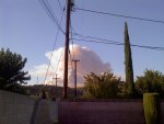
The picture is a view from my backyard.
 

Attachments

  • 0825091816.jpg
    0825091816.jpg
    53.2 KB · Views: 787
Last edited:

Mick

Member
Joined
Dec 19, 2002
Messages
2,532
Location
Western U.S.
Nice picture!

Hearing activity also on:
168.3500 USFS Region 5, shared use. Common user 1
169.2000 NIFC Air tactics 3
170.0000 USFS Air/Ground
 

Delldell26

Member
Joined
Oct 31, 2008
Messages
75
Location
Orange, CA
LASD has received info about Boy Scouts in the hills who are not accounted for at this time. LASD airship is not being allowed in the area to search for them though due to a large water dropping operation.
 

landonjensen

Member
Joined
Jun 23, 2006
Messages
885
Location
Area C
I put a feed under live audio on the Los Angeles Area feed.... Broadcasting all the frequencies above.
 

Mick

Member
Joined
Dec 19, 2002
Messages
2,532
Location
Western U.S.
These frqs are active this afternoon:

122.9250 Air to air
151.3025 CDF Tac 23
166.6875 Morris air attack
168.6125 Secondary Intra Crew
173.9125 USFS Region 5 Tac 4

Fire at 600 acres, 10% contained as of 1:04 PM local time.
http://www.inciweb.org/incident/1852/

Current Weather
Wind Conditions 15 mph SW
Temperature 99 degrees
Humidity 9%
 
Last edited:

Delldell26

Member
Joined
Oct 31, 2008
Messages
75
Location
Orange, CA
Does anyone know where the "Bridge to No Where" is? I keep hearing it as a reference point. Is it north or south of Morris Dam? Is it off the East Fork?

Thanks.
 

Mick

Member
Joined
Dec 19, 2002
Messages
2,532
Location
Western U.S.
For Google maps or Google Earth use 34 16 59.71 N, 117 44 48.88 W, or 9.87 miles northeast of the Morris Fire location at 34.204 latitude, -117.891 per http://www.inciweb.org/incident/1852/

Description
This trail follows the East Fork of the San Gabriel River in the San Gabriel Mountains. The final destination is the Bridge to Nowhere, a 120 foot high concrete arch bridge. This Bridge was constructed during the depression as part of a project to build a road up the East Fork. The road was washed away in a huge flood and the project was abandoned, but the bridge was still standing. Just beyond the bridge is the deepest gorge in Southern California. There is a 5000 foot rise out of the gorge in less than 3 horizontal miles. There is a beautiful campsite at the bottom near the trout infested river. On weekends you can arrange to bungee jump off of the bridge. This hike is no doubt the best in the entire range. If you want to extend this trip you can hike all the way up the river and stay at any of the numerous campsites along the way. I highly recommend this trip for any hiker. I wouldn't try this one during the spring because the river can get very rough. You must cross the river about 10 times on the way. Summer or Fall is the best time. I did this trip in August and it was great. I even saw a bighorn sheep ram on the top of a cliff.

Directions to Hike
Exit at Hwy. 39 (Azusa Ave.) from Interstate 210. Drive north through the mountains for about 15 miles until you pass Morris reservoir and San Gabriel reservoir. These two massive dams should give you an idea of how much water comes down the San Gabriel river. When you reach East Fork Road turn right. Follow this road until you reach a locked gate. Park here and visit the East Fork Ranger Station to get fire and wilderness permits. Hike past the locked gate along the fire road until you pass Heaton Flat campground. Go down to the river and hike along the river until you get to the bridge in 5 miles.

HIKE: Bridge To Nowhere « The (Single) GeekHiker
bridge to nowhere review - california hiking trails - TheBackpacker.com
San Diego Reader | Visit the "Bridge to Nowhere," deep in a roadless section of Angeles National Forest.
(New Destination) Hike to "The Bridge to Nowhere" - The Long Beach Canyon Hikers (Long Beach, CA) - Meetup.com
http://www.2020hindsight.org/2001/07/27/the-bridge-to-nowhere/
 
Last edited:

Mick

Member
Joined
Dec 19, 2002
Messages
2,532
Location
Western U.S.
More frqs in use

161.5200 151.4 L.A. Co. FD
163.7125 FIRESCOPE National Crew
168.0500 NIFC Tac 1
168.6250 Air guard, linked to 415.550
169.2000 NIFC Air Tactics 3 (This is for the Station Fire)

Station Fire:
169.200 NIFC Air Tactics 3
170.000 USFS Air to Ground Net
135.975 L.A. County Air Attack, Angeles NF Air Attack

Unknown which fire these is for:
168.6000 NIFC Tac 3
173.9875 USFS Region 5 Tac 6
 
Last edited:

clarkperry

Member
Joined
Apr 18, 2009
Messages
5
Location
Northridge, CA
Station Fire Ground Freqs

I live in Northridge and can see the red glow of the station fire from my house. This afternoon I was listening to the ANF freqs and heard some traffic. What Freqs should I be monitoring for the most interesting ground traffic?
 
Status
Not open for further replies.
Top