Just for background.
Looking at the picture -
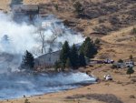
Is that a burnout operation? Or is the fire just creeping to the right?
I just see maybe 3 or 4 firefighters - all separated by large distances. There are 5 fire trucks there - there must be at least 5 firefighters there somewhere (unless someone walked back to the fire station to get another truck)
Even that tiny amount of flame can kill you if your pant leg catches on fire.
One ember can burn those homes down (if it lands in a sensitive place on the home).
There are probably 200 gallons of water on each of the smaller fire trucks. There might be 500 to 1000 gallons of water on the larger fire trucks. The larger fire trucks probably cant drive off the road without getting stuck.
If the large trees were fully involved in flames, it might take 1000 gallons of water to knock down the flames quickly (to prevent a thousand burning embers from flying thru the air).
3 trucks per home - 100 homes in danger - 300 trucks needed right there.
One simplex radio channel can tie all the firefighters together if they each have a portable radio - which they probably do. Comms thru the hillside are not possible. That hillside is essentially a radio wall.
Peter,
It is pretty tough to answer your questions and address your observations. You clearly don't know much about wildfire, but that is not unusual for most of the population. The most obvious and telling aspect of this picture is that the fire is backing. See the smoke moving from right to left? To advance to the right it has to burn against the wind. There a number of possibilities here. One, the fire burned in this area when the wind was moving from left to right, with the wind and the wind made a nearly 180 degree shift since then. I don't think this is the case. Two, the fire naturally backed into this area. Three, a burnout was conducted around the homes to protect them. With only the photo in hand the topography of the surrounding area is not known. Four, the head of the fire is to the right of the photo and is quite a distance away and this is a spot fire.
The position of the main fire relative to the picture is unknown. The photos location to the fire's burn pattern is not known, is this along a flank of the fire, is it at the heal or is it along a finger of the main fire? Did the head of the fire pass right through this area? What time of the day is this? If this is early in the morning or before 10 a.m. the fire might be laying down as a result. It could be the afternoon or closer to sunset, which would indicate that even during the peak of the burning period (of the day) the fire did not burn here with much intensity. All or the majority of these factors need to be known to explain what is going on in this picture.
If this is a spot fire ahead of the head, the people and positioning of the engines don't indicate the urgency such a situation normally presents. There is a small possibility that the fuels around the homes has been lit and a backfire is planed for the unburned fuels on the right. If so, the trees within a hundred feet or more of the homes would need to be cut down and the branches scattered away from them. Looking at the picture I think this is improbable.
Now for some of your comments. There are two Type I ENGINES, and three Type III ENGINES in the photo. Remember Peter, that these are engines, not trucks as trucks have an aerial ladder. Please look up ICS apparatus types and learn them at some point. It should be a part of your education in wildfire basics. Buy a book about wildland fire and read it. Books explaining the basics of wildland fire suppression and management are available at Amazon, but not likely to be available in a book store near you given where you live. You seem very interested and a book would probably be very interesting to you.
Now back to the engines, yes engines. If the full staffing for each engine type is in place there would be 4 people on each Type I and 3 on each Type VI engine. That would total 17 people. If minimum staffing for each engine is in place there would be 3 people on each Type I and 2 on each Type VI engine. That would total 12 people. There is a lot of smoke and the upper two houses block the view of some of the perimeter, so you end up with a "where's Waldo" type situation.
Even if a firefighter was wearing all cotton, it would be tough to die from a burning pant leg in these conditions. A person would have to stand in the little bit of low intensity flame and not move in order to burn up. A little gasoline soaked on the clothes would ensure the outcome. Otherwise, wearing Nomex clothing would make dying from burning pants highly unlikely. The isolated flames provide plenty of escape options so even getting hot is not going to happen in these circumstances. Some people trapped in a wildfire die due to burning from radiant heat. Some might even die from direct contact with flame. The biggest killer, however, is searing of the lungs. Air heated by intense fire is heated to temperatures hot enough, that when ingested burn the lungs and a person suffocates to death. The fire shelter is effective up to some point of protecting a person from radiant heat, but more importantly, if used properly, it traps air and prevents the lungs from damage. Many would think if they abandoned their fire shelter, or if they didn't have one, jumping into a creek where there bodies are submersed in water, that survival is a given. Not true as the air around a creek might be heated to a fatal temperature.
An ember from the fire shown in this picture starting a fire on or in these structures would be hard to conceive of. The fire is not burning with enough intensity to produce flying embers of the size needed for ignition. The fire is not producing sufficient radiant heat to start one of the trees on fire. The fuel around the homes, to the right and uphill, is not real heavy, although light, flashy fuels on isolated portions of fires, has killed firefighters so caution is always needed. The wind would have to shift considerably for an intense fire to burn in these fuels. The escape route and safety zone is obvious, however. "Run into the black" is the phrase here.
In the wildland/urban interface one truck per house is a tough ratio to meet when the urban area is large enough to deserve the designation. Why there appears to be 5 ENGINES for 3 houses cannot be explained. There are only 2 structure protection engines present, the Type VI's cannot be considered structure protection. They are useful for structure protection and are typically used for burnout and backfiring, as well as fuel removal around structures. They are also used for suppressing spot fires on the unburned side of a line when a backfire is ignited.
It would not take 1000 gallons to knock down the flame in one of those trees. A fog spray can be effective doing this, especially in this case of small trees and light to moderate fuels in the area. Full suppression of the flames is not always the goal, sometimes you are just trying to slow the consumption of the foliage so that less radiant heat is produced (if radiant heat is a threat to structures or firefighters) or to cool or knock down the embers produced so that they don't start spot fires or ignite a structure. One of the Type VI engines could handle one tree, especially in the circumstances in this photo.
It is impossible to know if each firefighters has a handheld using this picture. The policy and equipment of the unknown department or agency present here would have to be known. The federal wildland agencies equip each engine crew member with handhelds in most cases. In Colorado wildland fire suppression outside of fire districts and city/town limits, not in the jurisdiction of federal agencies (USFS, BLM etc.) is the responsibility of each county sheriff. At least in the western states, I've never heard of this arrangement before. Usually this is a state agency responsibility, but in Colorado the state provides funding for apparatus acquisition by counties, but other than that I don't know anything about this. The Colorado State Forest Service, not to be confused with the U.S. Forest Service, is very small when compared with other states.
It is impossible to know what the terrain outside of the picture is, so making a statement that the terrain forms a wall cannot be made. It is likely that the handhelds carried by the crews in the photo are assigned a tactical frequency for the division or group they are assigned to. It is also likely that they can hear most of the tactical traffic on the division they are assigned to. VHF High still has enough "terrain bending" characteristics to carry for some distance in all but extreme topography. Now there is a lot of extreme topography in the west, but from what I see in the photo, it is unlikely there is any close. Normally, a division is set up using a number of criteria. One is using the general guideline of only supervising 5 people or entities. So strike teams of engines (25 engines), five strike teams of crews (10 crews) or 5 strike teams of dozers (10 dozers). More likely a combination of all of these. It can also be a combination of single resources and strike teams or just single resources (1 engine, 1 crew, 1 dozer). Second, the division should be of the size it can be walked by the division supervisor in one shift. Third, simplex radio use covers the entire division. Of the 108 fires on my career log, only one division assignment involved a combination of terrain and division size where simplex operations were inadequate on the division. 108 fires is not really all that much experience compared to those who spend an entire career in fire management. I only spent years in fire management and the remainder in recreation, lands and law enforcement.
That one where division wide simplex coverage did not exist was in Yellowstone in 1988 on the North Fork fire. Everyone on the line was nearly working the job of the next level above their qualifications, so as a crew boss I was making many of the decisions normally made by my strike team leader, my strike team leader was nearly covering a "mini-division," a division was larger than most divisions, but not quite as large as a branch, etc. After that year large fires were assigned more than one incident management team so that this would not happen, but there isn't an official name for the area each team covers. At one point I had made a strike team leader/division supervisor level decision about the need to evacuate my portion of the division due to fire behavior I could see from my location, something neither my strike team leader or the division supervisor could not see. The division sup sent a Type I helicopter to my portion of the line and told me I should evacuate, based on what the division sup was seeing. The helicopters mission in this case was to raise me on the tactical frequency and relay the order. My response was I had made the decision a half hour prior and relay to the division sup that the entire division would most likely need to be evacuated based on what I was seeing, which was fire in a large area of unburned fuels making a run at a unstaffed portion of the line, that was between his and my location. Yellowstone in 1988 was so intense and large that this working above your qualifications was happening and that is why you now see more than one management team being assigned to fires. It is not uncommon now, but when the ICS was being developed very large fires similar to what happened in Yellowstone in 1988 were unprecedented in modern times (post the Big Burn of 1910).
It is doubtful that many people will read all of this post. I wrote it for you, Peter. I probably won't write another, as I've written a few more of some size in the past in response to your questions and uneducated comments. Please obtain a good book on wildland fire suppression and management so that you don't tax my time and the space on this website.
This post will not be proofread, so excuse me for any errors that may have been made.