Line of site calc and FCC database

Status
Not open for further replies.

fredg

Member
Premium Subscriber
Joined
Dec 23, 2007
Messages
107
Location
East Central Kansas
Line of site calculator and FCC database

I am using this line of calculator: http://www.qsl.net/kd4sai/distance.html

I went to the FCC database and pulled this data:

Site Elevation
(AMSL) 289.0m Height w/o Appurtenances 122.0m
Height w/Appurtenances 125.0m

Antenna 1
HAAT 76.0 Hgt to Tip 62.0m

So which height do I use for this location? Is it the Site Elevation? And then which one of the 3?

Or is it the Antenna Tip height? I am leaning toward Antenna Tip height...
 
Last edited:

nd5y

Member
Joined
Dec 19, 2002
Messages
11,297
Location
Wichita Falls, TX
For a simple line of sight distance calculator you would use the antenn height above ground level,
but the FCC and real RF path software use Height Above Average Terrain.

The stuff in the FCC database is measured in different ways and always in meters, not feet.
You have the site elevation AMSL (above mean sea level)
HAAT (height above average terrain)
Height without appurtenances is the height of the tower or structure above ground level.
Height with appurtenances is how far the antennas extend beyond the top of the tower.
Antenna HAAT is the height to the center of radiation (usually the middle of the antenna)
Height to tip is the HAAT to the top end of the antenna.

What you don't know is if Antenna 1 is at the top of the tower or side mounted down lower,
so as far as I know you can't really tell how far off the ground it is and you should probably
just assume it is on top and use the difference between the height with and without appurtenances.
 
Last edited:

fredg

Member
Premium Subscriber
Joined
Dec 23, 2007
Messages
107
Location
East Central Kansas
Last edited:

SkipSanders

Silent Key
Joined
Dec 19, 2002
Messages
1,059
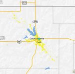
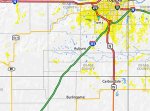
Fred, you're just living in a hole. My coverage software says your given location is at 380 m above sea level. Everything around you is higher, you're in a valley. If these attachments work, I'm including a line of sight pic for you to topeka (which was your interest), which shows that even if the earth between you were flat, you'd be out of luck, much less with the mountains between you. The 'street' maps show your actual 'visual line of sight' as bright yellow fill, around your location, and around the closest Topeka radio site I ran across.
 

Attachments

  • FredG-Topeka.jpg
    FredG-Topeka.jpg
    25.2 KB · Views: 789
  • FredGCoverage.jpg
    FredGCoverage.jpg
    39.1 KB · Views: 1,008
  • TopekaCoverage.jpg
    TopekaCoverage.jpg
    85 KB · Views: 982

fredg

Member
Premium Subscriber
Joined
Dec 23, 2007
Messages
107
Location
East Central Kansas
Thanks Skip, that is very cool stuff! I am lucky I get what I do. With the amp I am able to get a couple of cities to my north about 35 miles out in Geary county, just barely, and I can get Lyon county to my south east real well, it is about 25 miles out.

So even with a Yagi I have no hope getting Topeka, especially at 800MHz!

I am not sure if I get the second street map view around Topeka, it is all yellow but yet I can not receive it?? Sorry to be so dense....
 
Last edited:

kb2vxa

Completely Banned for the Greater Good
Banned
Joined
Mar 22, 2005
Messages
6,100
Location
Point Pleasant Beach, N.J.
Hi Fred and all,

My conservative way of thinking has always been the height of the antenna above ground is ground to base of the antenna, not the tip. Considering there are two figures I take the appurtenance to be the antenna or antenna structure atop the tower so I'd go with the lower figure to avoid inflating the result of my calculation.
 
Status
Not open for further replies.
Top