What are these for?

Status
Not open for further replies.

dave3825

* * * * * * * * * * * *
Premium Subscriber
Joined
Feb 17, 2003
Messages
7,651
Location
Suffolk County NY
Does anyone know exactly what this is used for? Its on Roslyn St in Islip Terrace

https://www.google.com/maps/@40.745...m4!1e1!3m2!1stYnMl7n7dD9iwawNgq3Z2w!2e0?hl=en


Then there's this. 2 boxes and a yagi on a pole. I have seen these on traffic lights but there are none around this and its in a residential neighborhood

https://www.google.com/maps/@40.745...m4!1e1!3m2!1scJRcNIbpghlrRM6WiGdCHg!2e0?hl=en


And these that are seen on the lie in nassau, and some of the interstates going in and out of the city.

https://www.google.com/maps/@40.788...m4!1e1!3m2!1sMFb3kXAap00sBElXW9MmOQ!2e0?hl=en
 

Darkstar350

Member
Joined
May 19, 2014
Messages
409
Location
Nassau County
The first one looks to me like some kind of cellular antenna...

But the second one is interesting - I cant imagine what that would be used for so close to power lines like that as power lines are known for giving off loads of interference...
 

TampaTyron

Beep Boop, Beep Boop
Premium Subscriber
Joined
Feb 1, 2010
Messages
1,095
Location
Phoenix, AZ
First one is a low profile cellular site

Second one looks like UHF SCADA system to control/indicate remote switching

Third is a high gain RFID 900mhz panel antenna used to detect automated toll roll customer equipment for billing/tracking

TT
 

15plus1

Member
Joined
Apr 8, 2010
Messages
394
Location
The State of Confusion
The antenna in the 3rd pic is, I believe, part of EZ-Pass tracking. I see the same antennas hanging on traffic signal lines over some (many) intersections. I think that is how they provide the ETA's to certain routes that u see posted on overhead and side of the road electronic signs. It is a way to track the timing of cars.. Like the red plastic card they ask u to hold while waiting on line at Disney.
 

mmckenna

I ♥ Ø
Joined
Jul 27, 2005
Messages
23,881
Location
Roaming the Intermountain West
I concur.

1. This is a small "micro" cell site. We have similar units at work. Verizion uses them on one of the roads I drive on to/from work. They are often fed via fiber optic cable back to a central base station where they tie into the rest of the network. Simple and low profile solution to addressing areas with deficient coverage.

2. I agree, SCADA for the electrical distribution up on the pole.

3. We have similar boxes along our highways, and they are sensors to detect traffic movement. They are not toll roads in our areas.
 

dave3825

* * * * * * * * * * * *
Premium Subscriber
Joined
Feb 17, 2003
Messages
7,651
Location
Suffolk County NY
First one is a low profile cellular site

Who would be using this? Its in a neighborhood.


Second one looks like UHF SCADA system to control/indicate remote switching
Switching of what? Would there be another one where the yagi is pointing?


Third is a high gain RFID 900mhz panel antenna used to detect automated toll roll customer equipment for billing/trackingTT

Are these similar to the ones hanging on traffic lights in intersections? I wonder how one would work on a scanner listening to an 800 / 900 trunked system
 

kayn1n32008

ØÆSØ
Joined
Sep 20, 2008
Messages
6,638
Location
Sector 001
The first picture could also be a 2.4 or 5.8GHz WISP site. Although a low profile cell site is also possible.

The Yagi is likely SCADA. Possibly used to remotely monitor power load. Or even do remote switching. The other 'end' could be close or many miles away.


Sent from my iPad using Tapatalk
 

w2lie

New York DB Admin
Database Admin
Joined
Mar 2, 2004
Messages
1,626
Location
Long Island, NY
Dave,
Since you also asked on my site, I'll copy/pasta my reply here as well:

Picture #1 is a Cellular O-DAS system. oDAS stands for Outdoor Distributed Antenna System. Think of it as a networked cell site that has low power transmitters on telephone poles instead of one big tower to cover the same area. These are popular in NIMBY areas.

Picture #3 looks like a RFID reader possibly for the EZ-Pass information to gather the time it takes to go from point A to point B.

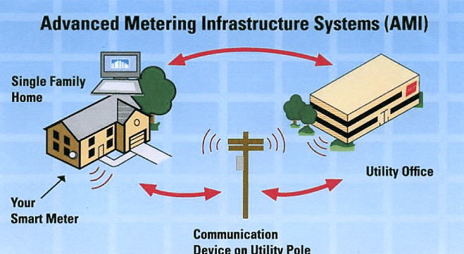
Picture #2, I'm going to go out on a limb and say maybe it is part of a smart meter network?
smartmeter1.jpg
 
Status
Not open for further replies.
Top