ACARS the future ... Inmarsat

Status
Not open for further replies.
Joined
Sep 16, 2012
Messages
51
Location
UK
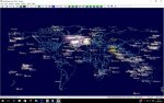
The attached image shows the future of ACARS monitoring

Inmarsat , ACARS via satellite.
All the plots shown , apart from the red triangles , are satellite ACARS in origin

Following the MH370 tragedy Inmarsat promoted the use of regular ACARS style updates via satellite.
The initial trials took place in the Pacific last year and gradually airline fleets are adopting the principle of regular updates.

The satcomms equipped a/c log in via L band to the satellites , the signal is then downlinked from the geo sat to the ground stations at C band.
These signals can be picked up with a standard satellite dish as small as 120cm.

Data via satellite is similar in content to Mode S.

Planeplotter now has a small network of satellite ground stations providing real time coverage across
Europe and Australasia .So far we have no stations in the US.

If you have a suitable satellite dish , then why not give it a try.
Full details on the Planeplotter forum.
 

Attachments

  • full.jpg
    full.jpg
    57 KB · Views: 2,237
Joined
Sep 16, 2012
Messages
51
Location
UK
Its quite some time since my last post and as can be seen from this image our coverage has extended to most of the Oceanic areas.

We are still looking for more satellite ground stations to expand this ground breaking project.

If you are willing to help , please PM me

Thanks
 

Attachments

  • aug212016.jpg
    aug212016.jpg
    74.2 KB · Views: 1,938
Joined
Sep 16, 2012
Messages
51
Location
UK
View from Space

2eku58g.jpg


Latest development from the PlanePlotter team....for the first time we can view Oceanic traffic
from a point in space , ideal for HF monitors and tracking mil traffic.
 

ki1022

Member
Premium Subscriber
Joined
Aug 12, 2011
Messages
38
Sorry, but that animation above doesn't make any sense to me. There are basically zero planes over the entire United States and Europe but thousands in a dense cluster centralized over Greenland/Iceland/North Atlantic??....
 

cg

Member
Premium Subscriber
Joined
Dec 13, 2000
Messages
4,599
Location
Connecticut
Likely the satellites are used only when they can't use the land based sites. I would assume that they are charged for the satellite data use but the ground stations are likely free or much cheaper

chris
 

kma371

QRT
Joined
Feb 20, 2001
Messages
6,204
Sorry, but that animation above doesn't make any sense to me. There are basically zero planes over the entire United States and Europe but thousands in a dense cluster centralized over Greenland/Iceland/North Atlantic??....

Believe it's mainly for oceanic travel since there aren't any ground stations in the ocean.
 
Joined
Sep 16, 2012
Messages
51
Location
UK
Sorry, but that animation above doesn't make any sense to me. There are basically zero planes over the entire United States and Europe but thousands in a dense cluster centralized over Greenland/Iceland/North Atlantic??....

Exactly !

Wherever there is ground based ADS-B coverage contact is handed off from satcomms

The globe view shows Inmarsat/Oceanic tracking only , consequently , there is no coverage over land masses.
Our ADS-B Mode-S Mlat system covers all that , but I stripped away all the "normal" tracking plots for the purpose of the demonstration.

Oceanic tracking via Inmarsat is becoming more and more common as operators strive to
meet the suggested 15 minute check-in format and a/c are fitted with Satcomm systems.

Best wishes

John
 
Joined
Sep 16, 2012
Messages
51
Location
UK
Hopefully this image will clear up any confusion.
These are all live plots....the yellow ones , standard ADS-B ...the rest Oceanic.

As you can see it is pretty busy over the Atlantic on a Saturday morning .
 

Attachments

  • Atlantic all.jpg
    Atlantic all.jpg
    108.8 KB · Views: 1,563

kma371

QRT
Joined
Feb 20, 2001
Messages
6,204
Hopefully this image will clear up any confusion.
These are all live plots....the yellow ones , standard ADS-B ...the rest Oceanic.

As you can see it is pretty busy over the Atlantic on a Saturday morning .

Very nice. I'm on the west coast, is Pacific coverage very active?
 
Joined
Sep 16, 2012
Messages
51
Location
UK
There is no antenna to make as such , we are just using a standard satellite dish of 1.2m or greater plus C Band PLL LNB made by Titanium satellite in the US.
From the dish the signal goes to your satellite receiver [ or voltage inserter] to an rtl dongle...from there into SDR# [ free] and then to JAERO [free] JAERO decodes the signal and passes it to PlanePlotter in ACARS format

From California your best satellite is Intelsat 4F3 at 98 degs west

Registration Insat4F3
Latitude 2°47.107N
Longitude 98°14.596W
Alt 35798km
Flight no Insat4F3

Its quite inclined , so we need as many dishes pointed at it as possible to get full 24/7 coverage...ideally some targeting above the arc and some below.

Feed two receivers into plane plotter already from California

Thanks for that....did you notice White Knight 2 test flight last week [Sept 8 ]

Best wishes

John
 

car2back

Member
Joined
Dec 19, 2004
Messages
2,974
Location
Tulsa, OK
I'd really like to get a C-band rig up and running with JAERO to monitor ADS-C. I wonder, is there any military use of this or is it strictly airlines?
 
Joined
Sep 16, 2012
Messages
51
Location
UK
Mainly commercial traffic although Atlas Air , SAM and AF1 flights do come up on Satcomms so too RAF and some of the other International Forces.
REACH use a different system , which we also display on PP
 

Thunderknight

Member
Premium Subscriber
Joined
Jan 31, 2008
Messages
2,217
Location
Bletchley Park
Unfortunately I can't host a dish (houses and trees), but if I were to download PP and pay the reg fee, would I see this oceanic data via the Internet sharing feature? Or is the Internet sharing only limited to ground ads-b?
 
Joined
Sep 16, 2012
Messages
51
Location
UK
Unfortunately I can't host a dish (houses and trees), but if I were to download PP and pay the reg fee, would I see this oceanic data via the Internet sharing feature? Or is the Internet sharing only limited to ground ads-b?

Hi Thunderknight

The Inmarsat/Oceanic data is available to anyone with a registered version of PlanePlotter , via the sharing server.

You can select what you want to see by the Options/Sharing /setup feature...

If you have any probs , PM me.

Whilst not being able to host a dish , all is not lost as next yyear we should see the initial tests of the Iridium space based ADS-B which should only require small yagi/ circular polarised antenna.

Best wishes


John
 
Joined
Sep 16, 2012
Messages
51
Location
UK
As announced in the recent release notes , to help with the identification and location of Inmarsat satellites , for ADS work , the latest versions of PlanePlotter download the up to date TLEs from US Space Command.This allows us to track the satellites in real time.
If you don't want to see the data , just go to options , chart , Inmarsat satellites and untick that option.

After a few refresh cycles , the satellite data will disappear.

Best wishes

John
 

open-sky

Member
Joined
Feb 1, 2013
Messages
22
Location
Graz-Austria
Hello ACARS Decoding friends!

last Weekend I started with my own Inmarsat-Acars Decoding Station! Outernet -Equipment and JAERO Software! I spent some hours to find the right satelit,but now the Station is running and I am very happy! the most aircraft signals come from aircrafts over the Atlantic Ocean(Civ.and Mil) ,but also from Europe and from the Indian Ocean,now my Station is completed ,ACARS on VHF with AOR 8000/8200 and MULTIPSK,HFDL-ACARS with AOR 7030/3030 and MULTIPSK.
The Outernet Equipment with the patch antenna and the low cost of purchase is recommended for Decoding Inmarsat Acars !!!

with best regards from Austria
open-sky
!!
 
Status
Not open for further replies.
Top