APT Image Problem

Status
Not open for further replies.

marksroberson

Member
Joined
Jun 16, 2014
Messages
154
Location
Florida Panhandle
I Have tried to receive the NOAA APT satellites on the 136-137 MHz range but i can never see the picture (its attached) i use MultiPSK and use a TYT TH-9800 Quad band radio can anyone help!
 

Attachments

  • FAX 2015-01-31 22h28m13s.jpg
    FAX 2015-01-31 22h28m13s.jpg
    148.1 KB · Views: 250
Last edited:

ka3jjz

Wiki Admin Emeritus
Joined
Jul 22, 2002
Messages
25,387
Location
Bowie, Md.
There's no pic...

This message has nothing to do with HF; moved...please watch what forums cover what subject.

Mike
 

rbm

Member
Joined
Jan 25, 2005
Messages
1,395
Location
Upstate New York
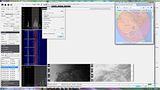
I'm not familiar with the specs. of your receiver, however ......
The APT bandwidth is 34 kHz.

I usually use 38 kHz for SDRSharp to allow for some doppler shift.

If you can tell that you have a strong signal, then the bandwidth may be your problem.
But, it looks to me like you have BOTH problems. A weak signal AND a bandwidth that is too narrow.

Rich

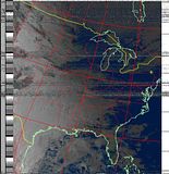
NOAA-18 APT reception and settings.


Edit: Here's what the processed image looks like.

 
Last edited:

cmeyer18

Member
Joined
Jan 31, 2015
Messages
6
What can I use to get the picture then?

If you don't already have a radio with that bandwidth, then the best thing you can do is get a rtl-sdr dongle and use that along with a decent antenna and SDR#.

I HIGHLY suggest reading through this quick start guide if you do plan on going this route. You can get the sdr itself for around $20 and any adapters you might need for a few more dollars. The rtl dongle uses a MCX connector (or a PAL connector on less common ones) and there are plenty of adapters to almost any other connector type. There are also some great tutorials on how to use it on that same site, and the community on Reddit is very helpful as well.

One of my favorite things to do with the rtl-sdr, besides weather images and ISS SSTV, is tracking aircraft. Plug the rtl in, run a program and I get the ADS-B packets from planes and can plot them on a map.
 
Status
Not open for further replies.
Top