
You are using an out of date browser. It may not display this or other websites correctly.
You should upgrade or use an alternative browser.
You should upgrade or use an alternative browser.
Funnel Cloud
- Thread starter gus426
- Start date
-
- Tags
- funnel cloud
- Status
- Not open for further replies.
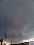
Odds are against it, since it looks like several similar clouds reaching down. Was it rotating? Where was it in relation to the core of the storm?
It was actually as the storm started to pass through so I would say these clouds were at the front of the storm, It seemed like the cloud was rotating very slowly but it did look like it was extending downward as I was watching it. Thank you for your response...
Gus
Gus
It was probably related to some outflow at the leading edge... A little rotation is possible in those, but odds are against it being a "real" funnel cloud.
I'd say it's just some "scud" or a poorly organized shelf cloud. Neither one are really indicators of any type of severe weather on their own, but a shelf cloud is usually associated with the gust front which can have winds that exceed severe limits. Scud is often confused with a funnel or tornado by untrained people, and even once in a while by trained spotters.
Were there any warnings issued with this storm?
Were there any warnings issued with this storm?
Last edited:
Looks like some isolated mammatus clouds to me.I could be wrong.
Seems too low for mammatus.
Brebuck
Member
My first impression was a wall cloud but was not near rear flank of storm
A wall cloud in a non-supercell could be anywhere, so don't let that part knock it out of possibility.
Brebuck
Member
A wall cloud in a non-supercell could be anywhere, so don't let that part knock it out of possibility.
I didn't know that. I'd like to learn more about this. Any suggestions?
A non-rotating wall cloud (i.e. a wall cloud in a non-supercell) is simply the lowering of the base where the air is rising into the storm. It has no meaning when it comes to severe weather. It has no significance in any form, other than saying "That's where the inflow to the storm is going up."
ONLY if a wall cloud is rotating is it an important feature.
ONLY if a wall cloud is rotating is it an important feature.
Brebuck
Member
I've not encountered this definition of wall cloud before, but this makes a lot of sense.
Thanks for the epiphany.
Thanks for the epiphany.
A non-rotating wall cloud (i.e. a wall cloud in a non-supercell) is simply the lowering of the base where the air is rising into the storm. It has no meaning when it comes to severe weather. It has no significance in any form, other than saying "That's where the inflow to the storm is going up."
ONLY if a wall cloud is rotating is it an important feature.
What about the tornados that come from non-supercell storms? Do those storms rotate too? I know, I'm a strom spotter and should know this but it was not covered in the training I took.
Those do not rotate. Rotating storms are supercells, non-rotaters are non-supercells...
But they can produce tornados.
Absolutely, but they don't come from a wall cloud.
Interesting! So in a non-supercell storm the only warning sign you get before the tornado is the funnel cloud.
That's pretty much it. There's nothing really that shows up in radar, there's no good location to look for. Most non-supercell tornadoes are much smaller / weaker than their supercell big brothers.
- Status
- Not open for further replies.
Similar threads
- Replies
- 3
- Views
- 495
- Sticky
- Replies
- 76
- Views
- 6K
BCD325P2/BCD996P2:
Scanner Problems After Power Outage?
- Replies
- 17
- Views
- 944