Help reading the map

Status
Not open for further replies.

Osprey1163

Member
Premium Subscriber
Joined
Dec 13, 2017
Messages
73
Location
Colorado
Now I've got my portable station together I've been watching the VHF propagation map at mennolink. I'm not sure exactly how to interpret the map & was wondering if I could get some help. When I click on a station within a zone I get lines radiating from that station to the edges of the zone. I'm also a bit confused by the table that shows packets send and received by a particular station.
Once I know what all this means, how do I use it to help me hit the distant repeaters I've got in my radio? I've got a good handle on propagation and how it works, just not quite sure about the map!

Chris
KB3SCN
 

edweirdFL

Member
Joined
Dec 10, 2004
Messages
580
Location
Daytona Beach, FL
The map is created by analyzing the paths of packets on the APRS frequency. When stations hear other stations at a greater than normal distance, this is used to forecast signal enhancement along that path. The callsigns are the APRS stations, and the lines are representative of the transmitting and receiving pairs of stations.

Here in Florida it's normal for some of the stations up and down the peninsula to be connected by lines inside a green or yellow blob, but when the patterns start going over the Gulf of Texas or over the Atlantic Ocean into distant states and the blob is orange or red, the chances are good for longer distance contacts than normal.
 

dave3825

* * * * * * * * * * * *
Premium Subscriber
Joined
Feb 17, 2003
Messages
9,438
Location
Suffolk County NY
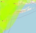
I live on Long Island. When it looks like this where yellow is overlapping my area, I can usually pick up public safety much more south of my location.


vhf.JPG
 

Osprey1163

Member
Premium Subscriber
Joined
Dec 13, 2017
Messages
73
Location
Colorado
The map is created by analyzing the paths of packets on the APRS frequency. When stations hear other stations at a greater than normal distance, this is used to forecast signal enhancement along that path. The callsigns are the APRS stations, and the lines are representative of the transmitting and receiving pairs of stations.

Here in Florida it's normal for some of the stations up and down the peninsula to be connected by lines inside a green or yellow blob, but when the patterns start going over the Gulf of Texas or over the Atlantic Ocean into distant states and the blob is orange or red, the chances are good for longer distance contacts than normal.

So, basically, if I'm inside one of the "blobs", especially orange or red ones I should be able to (in theory) make longer than normal contacts with other stations within that area?
 

Osprey1163

Member
Premium Subscriber
Joined
Dec 13, 2017
Messages
73
Location
Colorado
I live on Long Island. When it looks like this where yellow is overlapping my area, I can usually pick up public safety much more south of my location.


View attachment 102750
When I lived in Maryland when conditions were right I'd pick up Orange County, Virginia because they were on the same freq as the local PD. It was usually in the late summer when we'd get inversion layers that'd hover for days over the valley of the Chesapeake Bay, Potomac & Patuxent Rivers. Good times!
 
Status
Not open for further replies.
Top