Location Based Scanning Receiving Too Much

Status
Not open for further replies.

J805

Member
Joined
Nov 10, 2018
Messages
35
Location
Camarillo, CA
Hi All. I have a BCD536HP and a SDS200. Both are experiencing the same location based scanning issue.

I plugged a GPS into my 536 and first verified it was working - I live in Ventura County, California and set my zip code to a city in Florida. It loaded Florida and then immediately reloaded the California Database. With that said, I know my GPS is working correctly.

I then set up my service types to be Fire dispatch, Fire-Tac, Fire-Talk, Law Dispatch, Law Tac and Law Talk. I then set my range to 0.00. With these settings I'd assume I should only hear stuff very close to me?

However when I scan, I am hearing stuff very far away from me such as:

Temple City Sheriff
Los Angles County Sheriff
Los Angles County Sheriff Cresenta Valley
Los Angeles County Fire
Los Angeles County Search and Rescue
Kern County Sheriff (140+ miles from me)

All favorites lists are turned off, Full database is turned on.

I then unhooked the GPS, and punched in my zip code and set my range to 0.00 miles. Once again, I am picking up all the extra agencies very far away from me.

I tried the same zip code test on my SDS200 and the exact same thing happens, picking up alot more than it should. I read the whole coverage circle writeup, so I understand how that works, however these extra agencies that my scanners are picking up are very far away, considering my range setting.

What am I doing wrong?

Another question: When I have my service types set to only what I mentioned above, should I still see other agencies scroll by as being scanned when they do not fall within those service types? I am seeing others being scanned such as department of forestry, department of fish and game, national science and technology, etc. I would thing with these service types excluded, and the scanner would not even try to process them. Having these scroll by is just delaying the scan process for others that I am looking to pick up.

Any advice would be much appreciated.
 

jonwienke

More Info Coming Soon!
Joined
Jul 18, 2014
Messages
13,409
Location
VA
The distance used to decide whether something is scanned is the scanner Range setting + the Range setting of the Site or Department in the database. If the sum of those two things is greater than the distance to the site/department, it will be scanned. If scanner Range is set to 0 and you're still hearing stuff far away, something may have too large of a Range setting in the database.

ProScan has a tool for looking at site/department range circles on a Google Map; it's useful for sanity checking whether the location coordinates and Range settings are correct. Do Add Channels On Range in Sentinel to dump all of your local stuff into a single favorite list, and poke around to see if settings are wrong.

That said, cities and counties aren't circular, and even if you draw the smallest possible circle that completely encloses a region, it's still going to include territory outside the region.

Systems get scanned if any channels in the system match an active service type. So railroads get scanned if you have police Types active, because railroads have railroad police channels. NIST has police/fire channels for their on-site security fire people. Forestry has fire channels, etc.
 

phask

Member
Premium Subscriber
Joined
Dec 19, 2002
Messages
3,758
Location
zanesville
I have no idea what Kern county looks like (geographically), but many agencies are set at a range of 84. 84 may (probably) is totally appropriate, however, since that is a circle it can easily extend out of the Kern area.

IMHO - the only way to restrict it properly is to create a fav. list of just what YOU want. GPS scanning is great, but really it's best use is for mobile or use in an infrequent or temporary area. Any base use or even mobile in a frequently used location is better with a fav. list.

Also - this really explains range settings.

.
 

J805

Member
Joined
Nov 10, 2018
Messages
35
Location
Camarillo, CA
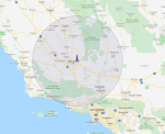
Thanks for the reply guys. I pulled up Kern County Sheriffs in ProScan and they are indeed set at 84 miles and extend well into other counties which they do not service. Is this an error with the range in the database or intentional? Or can I edit the master database on my own unit to correct this? The sheriff in my own county only has a range of 34 miles and Los Angeles County Sheriff is at 47 miles.

78909

Rather than loading the full database and doing location based scanning, can I scan only against my favorites lists with my gps on and specify a 0.00 range? Sometimes when in my vehicle in citys that I'm not familiar with, I don't know which favorites to load because some of the agencies are so mixed up in my area. Or what would be the best way to only hear what I want in unfamiliar areas?

Thanks
 

jonwienke

More Info Coming Soon!
Joined
Jul 18, 2014
Messages
13,409
Location
VA
City/county/state Departments should have location circles that are no bigger than necessary to enclose the city/county/state. Submit a correction to RRDB with an adjusted circle that is no bigger than necessary to enclose Kern County.
 

Ubbe

Member
Joined
Sep 8, 2006
Messages
10,210
Location
Stockholm, Sweden
While waiting for the change to make it into RR, if they think it is appropriate, and then into Unidens HPDB database, you could edit the database on the SD card.

On the SD card are a HPDB folder and in that are a textfile named hpdb.cfg
Open that with Windows Notepad that should be set so it doesn't automaticly wrap lines. In the file you'll see that California are StateID=6.
In the folder you also have all the state files s_000xxx.hpd so edit the s_000006.hpd using Notepad. Make a backup of the file by doing Save As and save the original file to someting like s_000006.hpd.backup

Use Notepads search function to find Kern County. Each line that starts with C-Group have the gps coordinates and the range and those will be valid for all following lines until the next line with C-Group.

Change to search for sheriff from that place in the file where you found Kern and it will find something like this:
C-Group CGroupId=16580 CountyId=197 Kern County - Sheriff
At that line you will see the 84.0 range value that you can edit to something more appropriate for you and then save the file as s_000006.hpd

Talkgroups also have ranges set to them and can be found the same way if you look at what the scanners display say about the system and department names and what TG it is, but instead of the C for conventional it is a T for a trunked T-Group that starts the line.

You favorite lists are built up the exact same way in the favorite_lists folder and the favorite_lists.config file but you can edit those in Sentinel.

If you feel that a rectangled area would be more suitable you can do that as well. In the T or C-Group you exchange the Circle text with Rectangles and add a new line below the Group line and start with the text Rectangle. The range will then be ignored as the rectangle will define the area.
You can create a dummy conventional or trunked TG department in a favorite list and set to rectangled area and gps coordinates for it and save and then copy that Rectangle line from the favorite list to the HPBD file so it will be added just below the Group line. Maybe ProScan have some sort of tool that lets you define the area on the map and save to a favorite list.

Trunked site frequencies are built up in the same way and if you search for the site name or its frequency, without a dot or comma, you will find the range value after the gps coordinates on the same line as the site name.

/Ubbe
 

phask

Member
Premium Subscriber
Joined
Dec 19, 2002
Messages
3,758
Location
zanesville
Thanks for the reply guys. I pulled up Kern County Sheriffs in ProScan and they are indeed set at 84 miles and extend well into other counties which they do not service. Is this an error with the range in the database or intentional? Or can I edit the master database on my own unit to correct this? The sheriff in my own county only has a range of 34 miles and Los Angeles County Sheriff is at 47 miles.

View attachment 78909

Rather than loading the full database and doing location based scanning, can I scan only against my favorites lists with my gps on and specify a 0.00 range? Sometimes when in my vehicle in citys that I'm not familiar with, I don't know which favorites to load because some of the agencies are so mixed up in my area. Or what would be the best way to only hear what I want in unfamiliar areas?

Thanks

I'm guessing the 84 miles is needed to cover the East to West width of the county.
 

ve1sef

Member
Premium Subscriber
Joined
Aug 30, 2007
Messages
693
Location
Halifax Regional Municipality, NS, Can
When I started using the 536/GPS in my vehicle I noticed significant overlaps with various counties in NS. Likewise some of the county was not inside the database range at all. I decided to create my own favorites lists to help solve this issue.
Ended up using my old "streets and travel" software; as well as, itouchmap.com to edit the center point of the county and reset the range.
While working on this project found sentinel quite useful, as it allows the creation of rectangular sectors as a option to circles. The rectangles seem to work better for some larger counties in Nova Scotia and New Brunswick.
 

jonwienke

More Info Coming Soon!
Joined
Jul 18, 2014
Messages
13,409
Location
VA
Ended up using my old "streets and travel" software; as well as, itouchmap.com to edit the center point of the county and reset the range.
ProScan lets you edit circles and rectangles in your FLs on a Google Map. You can drag and drop edges right on the map.
 
Status
Not open for further replies.
Top