Ever since I can recall, (ca. 1968) Dodge Street has been the line between north and
south with 72nd Street being the line between east and west. Since the city's recent
westward expansion, I'm not sure if the east/west line has moved in concert with the
annexations.
East and west is devide mainly by 42nd st and saddle creek, been for a while.
North and south is still devided by Dodge, but the Qwest center is in the southeast.
Elkhorn, or what was, is dispatch on Northwest Beat 101 is south of Dodge, Beat 102 is north.
I haven't kept track of OPD since their migration to 800 mHz. When both of our
departments were on UHF conventional, it was much easier since we had their
frequencies in our radios and vice versa. We went to 800 in 1995 which meant
a patch had to be set up for us to talk between departments, but at least we
could still monitor OPD traffic on the scanners in our cars. We've been able to
affiliate with their 800 system on our Spectras and XTS5000s but the radios don't
have the capability to scan between both the Sarpy and Douglas County systems.
Last week, OPD chased a car into Sarpy for several minutes. It was over before
our guys even knew it went down. That never would have happened in the old
conventional days. "K-A-A-Three-Twelve."
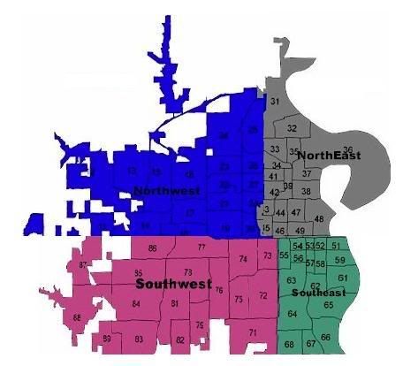
that brings up another question, what streets make up the OPDs jurisdictions borders? like when im coming into omaha on west dodge or maple, what street would it begin?
yeah i saw that map, thats actually what triggered me to start this thread, ill open up google earth and see if i can figure anything out regarding my last question