Phoenix Fire - Channels vs. Map Boundaries

Status
Not open for further replies.

KR7CQ

Member
Premium Subscriber
Joined
May 20, 2013
Messages
984
Location
Phoenix
In terms of Phoenix Fire dispatching, does anyone have anything recent showing what areas are covered by what channel (looking for exact boundaries / borders)?
 

KB7MIB

Member
Joined
Aug 17, 2003
Messages
4,195
Location
Peoria, AZ.
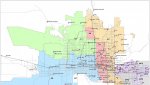
As far as I know, this is the only map floating around. It's probably a decade+ old, and only shows the A-deck assignments of that time.

https://forums.radioreference.com/attachments/fire-dist-map-old-jpg.45884/

Since then, channel A-11 has been added for Scottsdale, channel A-12 for Chandler and Sun Lakes, and A-13 for Tonopah and Harquahala Valley. A-3 was also worked in there somewhere.

As for the K-decks, K-6 covers the Northwest Valley, K-7 covers the Northeast Valley, K-8 covers the Southeast Valley, and K-9 covers the Southwest Valley. I-17 and Northern Ave are the approximate boundaries between East and West, and North and South. (The descriptions given in the RRDB for the K-deck geographical assignments, I believe, are wrong. I say this from my own listening.)

If anyone has an updated official map for both the A-deck and K-deck assignments, it would be greatly appreciated if it was linked to here.

John
Peoria
 

KR7CQ

Member
Premium Subscriber
Joined
May 20, 2013
Messages
984
Location
Phoenix
After a few days of listening and mapping, I have created this simple map with boundaries that I'm pretty solid on. Not positive on the lower right-hand portion of K8 as far as boundary, it may extend down to the I-10, but otherwise it was pretty clear that these are the boundaries. Most interesting is that K7 can't be easily defined by a regional name, as it is a sprawling boundary. Also, I've heard K8 called "South", "Southeast", and even "East" by different sources, and none of those descriptions really fit. If anything it's more like "East Central". Also almost everyone thinks of the East / West dividing line as I-17, but it appears to actually be 19th Avenue.

The PFD A Dec channels (though I had far fewer calls to confirm with) appear to follow the same boundaries as their K Dec cousins. Tactical channels such as K11 seem to be used wherever they are needed, regardless of boundaries, but I feel that boundaries for K6-K9 are pretty well nailed down at this point.

PFD channel map.jpg
 

JohnSpartan

Member
Premium Subscriber
Joined
Mar 16, 2013
Messages
212
Location
BEE08
K10,-12 are all major incident use, so that makes sense they aren't geographically associated. Seems to me they simply go down the list. First MI goes to 10, next to 11, and so on. Does that jive with your observations?
 

KR7CQ

Member
Premium Subscriber
Joined
May 20, 2013
Messages
984
Location
Phoenix
K10,-12 are all major incident use, so that makes sense they aren't geographically associated. Seems to me they simply go down the list. First MI goes to 10, next to 11, and so on. Does that jive with your observations?

Yes, now that you mention it, it does.
 

rpgaun

Member
Premium Subscriber
Joined
Apr 26, 2010
Messages
515
Location
Sun City, Az
So this brings up another map question. Is there a map of the A Deck channel assignments?
 
Status
Not open for further replies.
Top