Updated SAFE-T Tower Waypoints for GPS Receivers

Status
Not open for further replies.

racin06

Member
Joined
May 30, 2004
Messages
673
Location
Westfield, Indiana
The attached .zip contains the following files:

- SAFE-T Tower Waypoints.csv
- SAFE-T Tower Waypoints.gpx

The .csv file is for those of you who want to convert the SAFE-T tower waypoint information to another GPS receiver format other than Garmin.

The .gpx file is for Garmin GPS receivers. Open the .gpx file in Mapsource and upload the SAFE-T tower waypoints to your Garmin GPS receiver. I used the Tall Tower symbol to represent each SAFE-T tower. Also, under the comments section of each waypoint, I included both the primary (listed first) and secondary control channel frequencies.

I thought of this idea a few months ago while I was traveling (of course, with my scanners) in Southern Indiana, but I didn't know the nearest SAFE-T tower(s). I thought it would be nice to have each SAFE-T tower's lat/lon and frequency information in my GPS receiver. This sure beats searching across the 800 mhz band. Enjoy!
 

Attachments

  • SAFE-T Tower Waypoints.zip.zip
    7.6 KB · Views: 90
Last edited:

racin06

Member
Joined
May 30, 2004
Messages
673
Location
Westfield, Indiana
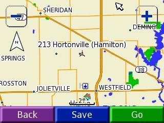
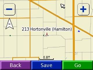
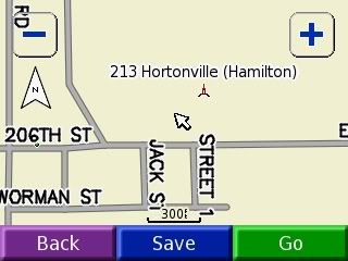
I thought I would post a few screenshots showing how finding a SAFE-T tower works on my Garmin Nuvi 350.


Screen showing nearest waypoints to my current location (home) that are stored in my Nuvi:

239.jpg


Screen showing Hortonville tower primary and secondary frequencies:

257.jpg


2.0 mile scale map view of Hortonville tower:

365.jpg


0.8 mile scale map view of Hortonville tower:

391.jpg


300 ft. scale map view of Hortonville tower:

446.jpg
 

trido

Retired
Premium Subscriber
Joined
Dec 19, 2002
Messages
1,176
Location
Southern In
racin06 said:
The attached .zip contains the following files:

- SAFE-T Tower Waypoints.csv
- SAFE-T Tower Waypoints.gpx

The .csv file is for those of you who want to convert the SAFE-T tower waypoint information to another GPS receiver format other than Garmin.

The .gpx file is for Garmin GPS receivers. Open the .gpx file in Mapsource and upload the SAFE-T tower waypoints to your Garmin GPS receiver. I used the Tall Tower symbol to represent each SAFE-T tower. Also, under the comments section of each waypoint, I included both the primary (listed first) and secondary control channel frequencies.

I thought of this idea a few months ago while I was traveling (of course, with my scanners) in Southern Indiana, but I didn't know the nearest SAFE-T tower(s). I thought it would be nice to have each SAFE-T tower's lat/lon and frequency information in my GPS receiver. This sure beats searching across the 800 mhz band. Enjoy!

WOW a big big thanks you are for sure worth more money.We sell some garmins mainly refurbs and I finaly got my self into GPS .Wife and I do some Geocaching(even have one at store) if you know of Geocaching.
Weeks ago I bought a Garmin IQUE M3 pretty nice.

thanks agian
 

trido

Retired
Premium Subscriber
Joined
Dec 19, 2002
Messages
1,176
Location
Southern In
racin06 said:
The attached .zip contains the following files:

- SAFE-T Tower Waypoints.csv
- SAFE-T Tower Waypoints.gpx

The .csv file is for those of you who want to convert the SAFE-T tower waypoint information to another GPS receiver format other than Garmin.

The .gpx file is for Garmin GPS receivers. Open the .gpx file in Mapsource and upload the SAFE-T tower waypoints to your Garmin GPS receiver. I used the Tall Tower symbol to represent each SAFE-T tower. Also, under the comments section of each waypoint, I included both the primary (listed first) and secondary control channel frequencies.

I thought of this idea a few months ago while I was traveling (of course, with my scanners) in Southern Indiana, but I didn't know the nearest SAFE-T tower(s). I thought it would be nice to have each SAFE-T tower's lat/lon and frequency information in my GPS receiver. This sure beats searching across the 800 mhz band. Enjoy!
Either I am doing something wrong but I am finding some towers in EVansville dist way off.
Take a look at tower site 405 it should be at state police post Highway 41 North and I64 .
http://www.radioreference.com/modules.php?name=RR&action=fcc&cs=WQEE931

How ever look at Garmin map it is way east?

Posey cty site is way off also Hederson ,Ky is way south of real local.
Let me know if it is me and my inputting coord into garmin?
example per fcc this is real lat/lomg for site 405 EVV post 38.15472 -87.54889 however you have in Garmin file N38 05.502 W87 19.536
Again let me know did i have to convert these or something I see theya re not listed exact same format are they?

checking some more seems like all the southernIND are wrong I checked some like yours in Hamitlon cty they are fine?
Must be soemthing on just these south towers lat/long


thanks
 
Last edited:

racin06

Member
Joined
May 30, 2004
Messages
673
Location
Westfield, Indiana
trido said:
Either I am doing something wrong but I am finding some towers in EVansville dist way off.
Take a look at tower site 405 it should be at state police post Highway 41 North and I64 .
http://www.radioreference.com/modules.php?name=RR&action=fcc&cs=WQEE931

How ever look at Garmin map it is way east?

Posey cty site is way off also Hederson ,Ky is way south of real local.
Let me know if it is me and my inputting coord into garmin?
example per fcc this is real lat/lomg for site 405 EVV post 38.15472 -87.54889 however you have in Garmin file N38 05.502 W87 19.536
Again let me know did i have to convert these or something I see theya re not listed exact same format are they?

checking some more seems like all the southernIND are wrong I checked some like yours in Hamitlon cty they are fine?
Must be soemthing on just these south towers lat/long


thanks

For some reason, I did make some mistakes on the coordinates. I checked the Evansville actual coordinates from the FCC database and I did, in fact, have the wrong coordinates in my file. Sorry for the error. I will double check the file over for additional errors over the next couple of days and re-post. Thanks for catching the error.
 

trido

Retired
Premium Subscriber
Joined
Dec 19, 2002
Messages
1,176
Location
Southern In
racin06 said:
For some reason, I did make some mistakes on the coordinates. I checked the Evansville actual coordinates from the FCC database and I did, in fact, have the wrong coordinates in my file. Sorry for the error. I will double check the file over for additional errors over the next couple of days and re-post. Thanks for catching the error.
Thanks no problem stilla great great thing youa re doing this is great to tell on my garmin how far from my QTH to each site in state.

Let us know when coorected I guess you will make a new complete file?
 

racin06

Member
Joined
May 30, 2004
Messages
673
Location
Westfield, Indiana
trido said:
example per fcc this is real lat/lomg for site 405 EVV post 38.15472 -87.54889 however you have in Garmin file N38 05.502 W87 19.536

You must have the position format in Mapsource set to hddd mm.mmmm, which I believe is the default setting in Mapsource. What is happening is that Mapsourse is just converting from the FCC format (hddd.dddd) to hddd mm.mmmm. This is fine; however, to change in Mapsource go to [Edit][Preferences] then click on the [Position] tab and change the Grid option to hddd.dddd format.
 

racin06

Member
Joined
May 30, 2004
Messages
673
Location
Westfield, Indiana
trido said:
Thanks no problem stilla great great thing youa re doing this is great to tell on my garmin how far from my QTH to each site in state.

Let us know when coorected I guess you will make a new complete file?

Yes, I will just upload a new file. Thanks for taking interest in my file. :)
 
Status
Not open for further replies.
Top