Sector Maps of ATC boundaries

Status
Not open for further replies.

nycrich

Member
Joined
Oct 31, 2006
Messages
171
Location
West Palm Beach
Does anyone know where one might purchase an ATC sector chart or get air route sector areas( low/high/ Ultra High) with frequencies specifically for Jacksonville and Miami ARTCC. I have found info on other ARTCC area, but none for the JAX/Miami sector. I have found many sites with freqs but no map/diagram of the sectors. I found one for JAX, but fres does not match up for high/low sectors. I have low/high enroute charts but they don't have all the freqs, and does not show the boundaries. A lot of scanner monitors moved/retired/ or plan to move to Florida, but it is hard to find updated info for the Florida region. There is a lot of aero and mil stuff here but it is hard to monitor or organise without the charts. Almost all other states I can find ATC sector areas/diagrams with freqs.
 

nycrich

Member
Joined
Oct 31, 2006
Messages
171
Location
West Palm Beach
Thanks for the info. I already have those. There are some errors with the freqs on those.I tracked flights with those and there are some errors going from TPA northbound. I give credit though to the individual that made them because it is a start and we can work with that. I moved from NYC to Tampa two years ago. I am currently trying to update and make a database that I can share. I did this while in NYC and posted it on the Grove website. I am currently doing a VHF Aero 118-138, Company freqs 128-132(posted on Grove website) and my main list milcom 225-400.
 

nycrich

Member
Joined
Oct 31, 2006
Messages
171
Location
West Palm Beach
I found this sector chart for Miami, from the FAA website but it is missing freqs/sectors names. It is attached as a zipped file.
 

Attachments

  • MIAMI ATC SECTOR.zip
    12.6 KB · Views: 343

EMD91123

Member
Joined
Feb 28, 2005
Messages
388
Location
Boynton Beach Florida
cool at least thats some sort of a start. What discrepencies are there by the way ?? I have been trying to get a few people on other forums to possibly monitor a few frequencies to let me confirm some handoff frequencies but no one seems to want to help out here. Would it be much to ask if you can monitor MIA ARTCC 128.225 and let me know handoff frequencies from that to the following frequency going into MIA/FLL/ AND RSW. I have been getting conflicting reports that RSW IS 132.35 AND FLL/MIA IS 132.4 and others are saying that it is only 134.75 for all three. Also trying to get handoff frequencies from 132.45 sector over Okeechobee. It would be greatly appreciated since I can program my scanners for the move in November
 

nycrich

Member
Joined
Oct 31, 2006
Messages
171
Location
West Palm Beach
That is Miami Center with all the low/high/ Ultra high routes. There are recent changes (2006) to the airspace and new RNAV approach plates. The Power Point presentation in zip format is still big 830kb? to upload.
Here is the link that you can read various changes:
http://web.nbaa.org/public/ops/airspace/fao

Going from TPA to FLL Ex Spirit 269( GIRLE RSW SWAGS1) filed for FL370
119.5 Tampa Tower
118.8 Tampa Dep
132.35 Mia-Sarasota Low FL370
132.4 Mia-Low descending
133.775 Miami App @ FL230
 

Attachments

  • 00744SWAGS.pdf
    189.1 KB · Views: 474

KC8MZM

Member
Premium Subscriber
Joined
Apr 19, 2003
Messages
35
Location
Cataula, GA
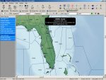
The demo version of Flight Explorer Personal Edition has the ability to display ARTCC boundaries along with the low, high, and ultra-high sector boundaries. Attached is a screen shot of some of the Miami high sectors.
 

Attachments

  • FE-screen-shot.jpg
    FE-screen-shot.jpg
    126.4 KB · Views: 7,097

nycrich

Member
Joined
Oct 31, 2006
Messages
171
Location
West Palm Beach
Firstly I wanted to thank KC8MZM for providing the link.It is a very useful program, even in demo mode. That program in demo mode without mapping aircrafts gives a good idea of sectors low/high/Ultra for the US. It is also capable of mapping airways, waypoint, fixes for the specified area for FREE. It allows anyone scanning for aero activity commercial, mil, etc to get a comprehensive picture of of the areas they can monitor. It really allows you to organise your database and have a good idea of aero traffic flow in your monitoring area.
Sarasota 132.35 is listed as High, but departure traffic out of Tampa International at low altitudes of 7000 ft report on that freq. I have noticed that there is a lot of low/high combination in the JAx & Mia ATC even during peak times. 128.225 is listed as Sarasota High covering that same area.
 

EMD91123

Member
Joined
Feb 28, 2005
Messages
388
Location
Boynton Beach Florida
I think the last peice of my puzzle is to confirm that there is a Jax super high freq of 128.425 overhead 125.175 and a Miami super high of 128.65 overhead the 119.825 area. Oh yes and maybe confirm that RSW departure and approach is on 127.2 and finally confirm that Miami Initial approach frequency is 124.85 coming from the NW and NE
 

k9swx

Member
Feed Provider
Joined
Apr 17, 2005
Messages
93
Location
Champaign, IL
Not to hijack the thread here, but does anyone have the ARTCC areas in lat/long format? I'd like to import that into another program without having to use the demo of Flight Explorer. Thanks!
 
Joined
Dec 19, 2002
Messages
493
Location
Colorado
k9swx said:
Not to hijack the thread here, but does anyone have the ARTCC areas in lat/long format? I'd like to import that into another program without having to use the demo of Flight Explorer. Thanks!


Yes Stan, having the lat/long boundaries for all the sectors in an area would be very valuable for users of the SBS-1 Mode-S radar tracker (like me).
 

nycrich

Member
Joined
Oct 31, 2006
Messages
171
Location
West Palm Beach
I don't know if this is what you need exactly, but in the "Overlay" task bar you can turn on the lat/long. Also in the "View" taskbar you can go into the "User define view settings" , scroll down to lat/long and specify different settings.
 
Status
Not open for further replies.
Top