• To anyone looking to acquire commercial radio programming software:

    Please do not make requests for copies of radio programming software which is sold (or was sold) by the manufacturer for any monetary value. All requests will be deleted and a forum infraction issued. Making a request such as this is attempting to engage in software piracy and this forum cannot be involved or associated with this activity. The same goes for any private transaction via Private Message. Even if you attempt to engage in this activity in PM's we will still enforce the forum rules. Your PM's are not private and the administration has the right to read them if there's a hint to criminal activity.

    If you are having trouble legally obtaining software please state so. We do not want any hurt feelings when your vague post is mistaken for a free request. It is YOUR responsibility to properly word your request.

    To obtain Motorola software see the Sticky in the Motorola forum.

    The various other vendors often permit their dealers to sell the software online (i.e., Kenwood). Please use Google or some other search engine to find a dealer that sells the software. Typically each series or individual radio requires its own software package. Often the Kenwood software is less than $100 so don't be a cheapskate; just purchase it.

    For M/A Com/Harris/GE, etc: there are two software packages that program all current and past radios. One package is for conventional programming and the other for trunked programming. The trunked package is in upwards of $2,500. The conventional package is more reasonable though is still several hundred dollars. The benefit is you do not need multiple versions for each radio (unlike Motorola).

    This is a large and very visible forum. We cannot jeopardize the ability to provide the RadioReference services by allowing this activity to occur. Please respect this.

Looking for Info on a tower that is not listed on sites

Status
Not open for further replies.

shortwaver

Member
Premium Subscriber
Joined
Jan 20, 2012
Messages
242
I hope I am posting this question to the correct group.

There is a tower near my house that is at least 100 feet tall, and has multiple small antennas on it. It is not listed on either Antenna Search, or the FCC's site. Close coordintes of the antenna are:

41.999803, -71.537424

I am looking to find out what services this tower supports. I have no great need to know, but I'm interested as it's one of the tallest structures around, and on the highest point. I assume coverage for these antennas is fairly wide.

Thanks!
 

mmckenna

I ♥ Ø
Joined
Jul 27, 2005
Messages
23,842
Location
Roaming the Intermountain West
Google Earth doesn't show anything. Neither does Google Maps. Must be new.

A photo might help us help you identify the antennas and the type of service they are providing.

Another option is to go to the site and see if there is anything that would identify a company, owner, etc.

Usually something new that goes up that isn't well identified tends to be wireless internet providers. At least that has been what I've found in my area.
 

TampaTyron

Beep Boop, Beep Boop
Premium Subscriber
Joined
Feb 1, 2010
Messages
1,094
Location
Phoenix, AZ
Could also be a rogue cell site, like a stingrays but run by organized crime or hostile foreign nations. I have seen a few reported near military bases and govt buildings here in the SE US. TT
 

KK4JUG

Member
Premium Subscriber
Joined
Dec 13, 2014
Messages
4,259
Location
GA
Could also be a rogue cell site, like a stingrays but run by organized crime or hostile foreign nations. I have seen a few reported near military bases and govt buildings here in the SE US. TT

Yeah, right.
 

iMONITOR

Silent Key
Premium Subscriber
Joined
Sep 20, 2006
Messages
11,156
Location
S.E. Michigan
Stingray Tracking Devices: Who's Got Them?
https://www.aclu.org/issues/privacy...ogies/stingray-tracking-devices-whos-got-them

Like Tampa Tyron said, used by organized crime. Just look at the major players at the bottom of the link posted above!


Law Enforcement Uses StingRays To Spy On Americans And Lies About It
https://www.huffingtonpost.com/kris-hermes/law-enforcement-uses-stin_b_12080634.html

Yes, law enforcement can spy on your cellphone. The FBI insists it's not doing it.
https://www.pri.org/stories/2016-02...py-your-phone-fbi-insists-theyre-not-doing-it

D.C. court rules tracking phones without a warrant is unconstitutional
https://www.cbsnews.com/news/d-c-court-rules-warrant-is-required-for-stingray-cell-phone-tracking/
 

ecps92

Member
Joined
Jul 8, 2002
Messages
14,406
Location
Taxachusetts
If you go to STREET Level View at the end [cul-da-sac] of Fairmount St, it is visible
as well as the Business Complex on the other side.

Still hard to see other than the shadow from those two angles.

an FCC Radius search shows nothing near-by, except the Part-time Fire Station down Fairmount St
Searched 0.1000 Mhz to 999.9999 Mhz and 2.0 Mile Radius
Google Earth doesn't show anything. Neither does Google Maps. Must be new.

And Re-looking at the Original Aerial View, there is a shadow, that could be the tower, depending on the time of the photo, it would be from the sun setting in the west.

A photo might help us help you identify the antennas and the type of service they are providing.

Another option is to go to the site and see if there is anything that would identify a company, owner, etc.

Usually something new that goes up that isn't well identified tends to be wireless internet providers. At least that has been what I've found in my area.
 
Last edited:

shortwaver

Member
Premium Subscriber
Joined
Jan 20, 2012
Messages
242
Google Earth doesn't show anything. Neither does Google Maps. Must be new.

A photo might help us help you identify the antennas and the type of service they are providing.

Another option is to go to the site and see if there is anything that would identify a company, owner, etc.

Usually something new that goes up that isn't well identified tends to be wireless internet providers. At least that has been what I've found in my area.

Thanks for the follow ups guys.

Google earth does show it, but because there isn't a shack nearby, it's almost impossible to see, except for its shadow. **First, shut off the 3D feature in Google Earth. Then find the dead-end of Fairmount St; the antenna is in a straight line from Fairmount St, about 400-500 feet away to the west, just over the North Smithfield line. The antenna is in the top third of that clearing.

Thanks for the info, I'll try to get pictures of it so some can perhaps identify the antennas.
 

mmckenna

I ♥ Ø
Joined
Jul 27, 2005
Messages
23,842
Location
Roaming the Intermountain West
If there is no visible infrastructure at the base of that tower, that sort of adds some info.
A cellular site would have a considerable amount of equipment for the base stations, power, generator, cooling, etc. at the base.
An LMR tower would be similar.

But I've seen sites where an FM broadcast transmitter gets stuffed in a garden shed at the base of the tower.

Likely if there is no visible or very little visible infrastructure at the base, that sort of points towards a Wireless Internet Provider.
They are kind of known for tossing up systems "overnight" with no FCC info, as many of their systems are not "licensed".

Photos would confirm that.
 

shortwaver

Member
Premium Subscriber
Joined
Jan 20, 2012
Messages
242
If there is no visible infrastructure at the base of that tower, that sort of adds some info.
A cellular site would have a considerable amount of equipment for the base stations, power, generator, cooling, etc. at the base.
An LMR tower would be similar.

But I've seen sites where an FM broadcast transmitter gets stuffed in a garden shed at the base of the tower.

Likely if there is no visible or very little visible infrastructure at the base, that sort of points towards a Wireless Internet Provider.
They are kind of known for tossing up systems "overnight" with no FCC info, as many of their systems are not "licensed".

Photos would confirm that.


I'll try to get some pictures shortly. Thanks
 

Motoballa

Member
Premium Subscriber
Joined
Dec 15, 2015
Messages
403
Interesting, never heard about StingRays before. Curious to see what it ends up being.
 
Last edited:

mikewazowski

Forums Manager/Global DB Admin
Staff member
Forums Manager
Joined
Jun 26, 2001
Messages
13,510
Location
Oot and Aboot
A cellular site would have a considerable amount of equipment for the base stations, power, generator, cooling, etc. at the base.

Those are the old days.

These days, the base stations are 1-2RU high, the radios are tower mounted, the switch is 1RU high, the power plant is about 12RU high, the cooling is free air and the only backup power are a couple of deep cycle batteries.

All that fits in a couple of small cabinets at the base.
 

W1KNE

Owner ScanNewEngland
Database Admin
Joined
Feb 15, 2010
Messages
1,939
Location
New England
Looks like a receive site of some kind. There is a connex trailer at the base of the tower.
Not visible on GE current view, but rewind to 4/2012 and you can see it clearly.
 

iMONITOR

Silent Key
Premium Subscriber
Joined
Sep 20, 2006
Messages
11,156
Location
S.E. Michigan
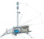
When we go to Soaring Eagle Casino in Mt. Pleasant, Michigan. There is a transportable/temporary cellular tower (similar to the illustration) set way back on the edge of the woods on M20. I've often suspected it being a StingRay system, and being in the vicinity of a casino might make sense. It's been there a few years now.
 

Attachments

  • Cell_on_wheels_demo (Mobile).jpg
    Cell_on_wheels_demo (Mobile).jpg
    15 KB · Views: 271

ecps92

Member
Joined
Jul 8, 2002
Messages
14,406
Location
Taxachusetts
It is a CoW [Cellular on Wheels] Many Cell/PCS providers put them out at sites where a high volume is sporadic [events], many times used to also determine if they need a Permenant site, or leave the CoW [many Stadiums see an influx of them for Play Off games]
When we go to Soaring Eagle Casino in Mt. Pleasant, Michigan. There is a transportable/temporary cellular tower (similar to the illustration) set way back on the edge of the woods on M20. I've often suspected it being a StingRay system, and being in the vicinity of a casino might make sense. It's been there a few years now.
 

shortwaver

Member
Premium Subscriber
Joined
Jan 20, 2012
Messages
242

Just a note also that the tower has been up for at least 2 years.

Interesting, but it doesn't look like a wind turbine, and it doesn't have any lights on it, as stated in the FAA form linked. The structure name listed matches the name of the owner of the property, St. Antoine, which runs a nursing home and assisted living facility there.

I tried to get a good pic yesterday, but the pathway seen leading to it from the north is quiet overgrown, and taking my truck down there would have been noticed.

The tower itself doesn't appear to have any dishes or vertical antennas on it. It does have horizontal antennas approximately 10 feet in length that are set up at intervals, kind of link a discone, but with them sticking straight out, and only 2-4 per segment.
 
Status
Not open for further replies.
Top