Antenna Identity

Status
Not open for further replies.

btritch

Member
Joined
Nov 27, 2006
Messages
1,941
Location
Paragould/Greene County AR
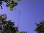
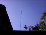
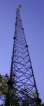
Anyone know what kind of antenna this is! I have NEVER saw one like this before! It's some kind of receive/transmit tower but I've never saw one like it before, Anyone have any idea or anyone ever saw one of these before?
 

Attachments

  • picture.jpg
    picture.jpg
    163.3 KB · Views: 432
  • picture002.jpg
    picture002.jpg
    86.2 KB · Views: 431
  • picture003.jpg
    picture003.jpg
    9.7 KB · Views: 423
  • picture004.jpg
    picture004.jpg
    59.1 KB · Views: 422
  • picture005.jpg
    picture005.jpg
    78 KB · Views: 428

Dewey

Member
Joined
Dec 19, 2002
Messages
1,025
I see three antennas. The one on the left looks like a typical tower "whip" antenna. The two round objects look like some type of microwave link or relay station to me. Of course, I'm not a tower person, and could be totally wrong.

Dewey
 

blinddog50

Member
Joined
Sep 17, 2005
Messages
254
Location
Undisclosed urban location.
Best guess would be a radio relay from the Memphis Airport.
Omnidirectional antennas with a radome covering.
The whip is probably there as a back up.
Probably belongs to FedEx.
 

N3LLO

Member
Joined
May 17, 2005
Messages
44
Location
New Ipswich, NH
Actually, I would guess the 2-bay array to be circularly polarized antennas, more specifically FM broadcast. Take a look on Radio-Locator to see if there are any translators or LP FM stations in that town. Drill down on the details and check the coordinates. I'm guessing that's what the two randomes are. As for the whip, it may be STL (studio-to-transmitter link) for the translator... or perhaps something unrelated.

(Guessing this is near the town in your sig block)
http://www.radio-locator.com/cgi-bin/locate?select=city&city=Paragould,+AR&state=&x=9&y=9

Better yet, bring a frequency counter to that same spot. That will tell you!
 
Last edited:
N

N_Jay

Guest
I thought about circular polarized broadcast (FM or TV) antenna, but they just don't look right.

I am sticking with radar, probably doppler weather radar.
 

btritch

Member
Joined
Nov 27, 2006
Messages
1,941
Location
Paragould/Greene County AR
If it helps, It's atop a mountain in a state park at the visitors center... I thought maybe Telephone or Internet?
It's actually in pope county Arkansas or Russellville Arkansas at mt. nebo state park. And it's aimed toward town. The state park system use low band 46 mhz band too.

I thought it was a microwave link for the statewide radio system but the ones who have saw those in the past say no, It's not big enough.
 

phatboy48

Member
Joined
Feb 6, 2009
Messages
40
That antenna appears to be an FM broadcast array protected by radomes. Most likely some sort of information broadcasting service sponsored by the park similar to the TIS stations on the AM band. The whip type antenna is a generic two way comm antenna, probably used on their park radio base station.
 

btritch

Member
Joined
Nov 27, 2006
Messages
1,941
Location
Paragould/Greene County AR
That antenna appears to be an FM broadcast array protected by radomes. Most likely some sort of information broadcasting service sponsored by the park similar to the TIS stations on the AM band. The whip type antenna is a generic two way comm antenna, probably used on their park radio base station.

I thought about that, Guys, There IS a Little Rock Based NWS NOAA Transmitter Registered to A city very close to that location, Perhaps it's NOAA WEATHER RADIO Broadcasts?

I had a radio when I took the pics but I never heard any bleed over, there were three towers on that mountain, One was county dispatch etc. One was cellular phone, and the one I posted never seen before!

No I don't think they're big enough for Weather Radar, They look only about 2 feet in diameter across but then again, They're over a 100 ft. in the air too but I've seen weather radar, It really doesn't look like that to me.. Could be though.
 
Last edited:

N3LLO

Member
Joined
May 17, 2005
Messages
44
Location
New Ipswich, NH
They're not radar and not microwave backhaul. I'm strongly suspecting FM or WX.

Is there any evidence of a weather station (rain/wind/temp measurement) installed around that shelfter?

If you find yourself tower hunting and don't already have one, a frequency counter would be a GREAT thing to have...
 
Last edited:

btritch

Member
Joined
Nov 27, 2006
Messages
1,941
Location
Paragould/Greene County AR
No, I Didn't see anything except a small antenna on a pole about 20 feet above the building, It was a loop. that's all I noticed, If you get a frequency counter how would it work, Wouldn't you have to key out to get it to work?

Are they expensive? Anyone know where ta get one a Those? That'd be nice!
 

nd5y

Member
Joined
Dec 19, 2002
Messages
11,297
Location
Wichita Falls, TX
It is an FM station.

1. Get Google Earth.
2. Get Google Earth FCCInfo file from Cavell Mertz & Asooc.
3. Open the file in Google Earth.
4. Find Mount Nebo State Park on Google Earth.
5. Check the FM and ASR Towers layers.

Or else look up the coordinates on the FCC database.

Why can't anybody else do this?
 
Last edited:

nd5y

Member
Joined
Dec 19, 2002
Messages
11,297
Location
Wichita Falls, TX
If you are at a site with broadcast stations or multiple transmitters operating at the same time you want a a scanner with Close Call or a spectrum analyzer . A frequency counter would be useless.
 
Last edited:

N3LLO

Member
Joined
May 17, 2005
Messages
44
Location
New Ipswich, NH
Hi, Tom.

The reason I suggested a counter at that particular site was that there didn't seem to be a dense cluster of transmitters there.

Matt
 

btritch

Member
Joined
Nov 27, 2006
Messages
1,941
Location
Paragould/Greene County AR
It is an FM station.

1. Get Google Earth.
2. Get Google Earth FCCInfo file from Cavell Mertz & Asooc.
3. Open the file in Google Earth.
4. Find Mount Nebo State Park on Google Earth.
5. Check the FM and ASR Towers layers.

Or else look up the coordinates on the FCC database.

Why can't anybody else do this?

I've used google earth but I Didn't know you could do that...On The Other Hand, Anyone Know Where To Find A Frequency Counter?
 

btritch

Member
Joined
Nov 27, 2006
Messages
1,941
Location
Paragould/Greene County AR
Ok, Using The Google Earth Feature, I Found This:

1> KYEL 105.5 FM
2> Structure Registration 1232925
Structure Height 400 FT.
Height Above Ground 403 FT.
Height Above Mean Sea Level 823 FT.
Structure Type Tower
Owner KERM, Inc.
3> Structure Registration 1243667
Structure Height 260 FT
Height Above Ground 265 FT
Height Above Mean Sea Level 878 FT
Structure Type Tower
Owner Pinnacle Towers Acquisition LLC
4> KCJC FM
5> WPOR 994
6> KPD 35
7> 97.1 MHZ Ch. 246D Application
Power 0.013 KW
1,920 Ft. AMSL
Facility ID 146191
Radio Assist Ministry
8> Structure Registration 1224177
Structure Height 199FT
Overall Height Above Ground 219FT
Overall Height Above Mean Sea Level 1,958 FT
Structure Type TOWER
9> 96.9 MHZ Application
Power 0.013KW
96.9 MHZ Ch 245D
1,920 FT AMSL
Facility ID 150968
Radio Assist Ministry

Sooooo, I Think ND5Y Is Right! A Frequency Counter Would Be Useless! LOL
Thanks Guys For The Help So Far!
So Guesses Would Be FM Broadcasts? They Don't look like that though do they? I thought they were regular X looking things on the tower for FM.
 

N3LLO

Member
Joined
May 17, 2005
Messages
44
Location
New Ipswich, NH
I thought they were regular X looking things on the tower for FM.

On the contrary, the most common polarization for FM is circular (not vertical, nor horizontal) to cancel noise. The randomes shown in your photo are meant to enclose antennae that look like those at Broadcast Electronics: Circularly Polarized FM Antennas

and are meant to prevent ice build-up.

Some even look like grappling hooks.. Check out the array for the predominant FMs in Boston:
http://gallery.bostonradio.org/2004-05/rko-pru/100-01744-med.html


Without taking a counter to that site, you'd never know. My thinking behind the suggestion was:
a) Whereas other things that may be broadcasting/being received at the site might be intermittent, an active FM would be transmitting 100% of the time.

b) Unless the FMs there are extremely low-power translators, they would likely be a lot stronger than the other transmitters there.

You had asked for a way to ID what (type) a particular antenna was. A counter is one tool in an antenna enthusiast's arsenal that could be used to discover exactly what a particular antenna is transmitting (by frequency). Then again, I'm not ignoring the fact that there may be other transmitters (not shown) at that site, making in an RF-intense environment, in which case, the counter would jump around and would not be very useful.

Before the google earth/overlay suggestion was made, I only saw two FM antennas and a vertical, with nothing else in sight. I would expect that that combination of antennas would likely by a 2-bay array for th e FM and a receive antenna used for STL (studio-to-transmitter link). If that were the case, and there were no other strong signals nearby, there would be only a single frequency with a super-strong field strength at that location.

In any event, happy hunting.
 
Last edited:
Status
Not open for further replies.
Top