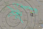
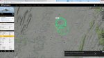
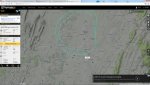
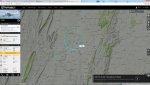
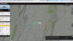
I'm sure he's a gov't spook tracking/monitoring someone. Something has been going on in Hagerstown for a while now. These were all from the same day back in October. There's another one but I couldn't attach it, I hit the max #
That makes sense as Sierra Nevada Corporation has an IMS plant in Hagerstown. I have a client who works there and he was just here today. I would have asked him had I known, but I'm sure he wouldn't have had anything to say about it ;-)
Nothing unusal in the Hagerstown area for exactly the reasons you mention,that is why i will be glad when they get the plant here up and running,they have already said they will doing mods for Military aircraft both fixed wing and rotary wing,i guess i will have to get more radios and more adsb boxes just to keep up ))!
The FBI has been outed in flying surveillance flights over large cities
Mostly for cellular recon and the aircraft acts as a cell tower collecting huge amounts of data from 5,000 ft.
There are other reasons as well relating to data collection for GIS. Essentially mapping information that cannot be obtained by satellite
Most all classify under the category of aerial surveying
It's easy to differentiate between GIS/mapping flights and the FBI's unholy air force. I have some screenshots I took of activity around here last fall. It was a Russian MiG making some super precise maneuvers at incredible speed... the MiG is registered to a company out of Oklahoma, I believe. I'll have to dig those screenshots out tomorrow.


") ))!
))!