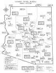
Arizona DPS Transmitter Location Map

Status
Not open for further replies.
V

VGSMC_8520

Guest
Here's something I made a while ago for my own personal reference, and wanted to share with everyone here too. Feel free to use, re-distribute, print off 100 copies and scribble all over them, whatever. Also, point out any errors, please.

MmEr9bC.jpg


High resolution 600 dpi 8.5 x 11 jpg here

data sources: Openstreetmap, RadioReference.com

I don't have DPS district polygon data, but maybe I'll draw those and swap the county boundaries out in the future.
 
Last edited:

SCPD

QRT
Joined
Feb 24, 2001
Messages
0
Location
Virginia
What you are showing is not all the transmitters of the agency. The transmitters shown are those closest to the district offices. There are 6-8 more transmitters per district in use. That is just quick guess.
 

E5911

Member
Premium Subscriber
Joined
Dec 19, 2002
Messages
559
Location
the lower desert
Dist 4 repeaters on Cunningham, oatman, smith and Black mtn in parker

Sent from my SCH-I535 using Tapatalk
 

cellphone

Silent key.
Premium Subscriber
Joined
Dec 28, 2002
Messages
1,811
Location
Ahwatukee, AZ (Phoenix)
Here is an old transmitter map. Note that it is showing the old frequency for Metro East (District 13). I don't recall where this was obtained, but I think it was one of the Yahoo groups.
 

Attachments

  • Tower Map.jpg
    Tower Map.jpg
    75.1 KB · Views: 3,169
V

VGSMC_8520

Guest
Here is an old transmitter map. Note that it is showing the old frequency for Metro East (District 13). I don't recall where this was obtained, but I think it was one of the Yahoo groups.

Wow, very nice! Thanks for the info.
 
Status
Not open for further replies.
Top