
- Forums
- U.S. Regional Radio Discussion Forums
- Colorado Radio Discussion Forum
- Colorado Incidents and Breaking News
You are using an out of date browser. It may not display this or other websites correctly.
You should upgrade or use an alternative browser.
You should upgrade or use an alternative browser.
Current storm moving in for a few days!
- Thread starter jimmnn
- Start date
- Status
- Not open for further replies.
Wirelessly posted (MOT-QA30/00.72 UP.Browser/7.2.7.5.610 (GUI) MMP/2.0)
Colorado: wait ten minutes or drive ten miles.....
Colorado: wait ten minutes or drive ten miles.....
Warbirdhunter
Member
They keep talking about this storm, how big it's going to be. So far in SE Denver it's just cold and gray!
For what it's worth Charles the Winter Storm warning for the Denver Metro Area does not begin until 1800hrs and goes thru Sunday.
Jim<
URGENT - WINTER WEATHER MESSAGE
NATIONAL WEATHER SERVICE DENVER CO
1057 AM MST SAT NOV 14 2009
...WINTER STORM TO BRING DECENT SNOWFALL TO NORTHEAST AND NORTH
CENTRAL COLORADO TONIGHT AND SUNDAY...
.A WINTER STORM STORM SYSTEM IS EXPECTED TO MOVE INTO THE
FORECAST AREA TONIGHT AND REMAIN OVER THE FORECAST AREA THROUGH
SUNDAY. THE HEAVIEST SNOWFALL WITH THIS STORM IS EXPECTED OVER
AREAS EAST OF THE CONTINENTAL DIVIDE OUT ONTO THE PLAINS OF
NORTHEAST COLORADO. THIS INCLUDES THE FRONT RANGE FOOTHILLS...THE
I-25 URBAN CORRIDOR...THE PALMER DIVIDE AND MOST OF THE NORTHEAST
PLAINS OF COLORADO.
HAZARDOUS TRAVEL CONDITIONS ARE EXPECTED TO DEVELOP BY TONIGHT
AND CONTINUE THROUGH SUNDAY AS THE STORM SYSTEM MOVES ACROSS COLORADO.
...WINTER STORM WARNING IN EFFECT FROM 6 PM THIS EVENING TO 5 PM
MST SUNDAY...
THE NATIONAL WEATHER SERVICE IN DENVER HAS ISSUED A WINTER STORM
WARNING FOR HEAVY SNOW FOR THE URBAN CORRIDOR...AND SOUTHERN WELD
COUNTY TONIGHT THROUGH SUNDAY.
SNOW WILL DEVELOP ACROSS THE WARNING AREA EARLY THIS EVENING AND
CONTINUE THROUGH LATE SUNDAY AFTERNOON. SNOW MAY BE HEAVY AT TIMES
FROM MID EVENING THROUGH ABOUT MID DAY SUNDAY. SNOW ACCUMULATIONS
FROM THIS STORM WILL RANGE FROM 6 TO 12 INCHES.
Wirelessly posted (MOT-QA30/00.72 UP.Browser/7.2.7.5.610 (GUI) MMP/2.0)
It's coming down!
It's coming down!
Warbirdhunter
Member
For what it's worth Charles the Winter Storm warning for the Denver Metro Area does not begin until 1800hrs and goes thru Sunday.
Jim<
URGENT - WINTER WEATHER MESSAGE
NATIONAL WEATHER SERVICE DENVER CO
1057 AM MST SAT NOV 14 2009
...WINTER STORM TO BRING DECENT SNOWFALL TO NORTHEAST AND NORTH
CENTRAL COLORADO TONIGHT AND SUNDAY...
.A WINTER STORM STORM SYSTEM IS EXPECTED TO MOVE INTO THE
FORECAST AREA TONIGHT AND REMAIN OVER THE FORECAST AREA THROUGH
SUNDAY. THE HEAVIEST SNOWFALL WITH THIS STORM IS EXPECTED OVER
AREAS EAST OF THE CONTINENTAL DIVIDE OUT ONTO THE PLAINS OF
NORTHEAST COLORADO. THIS INCLUDES THE FRONT RANGE FOOTHILLS...THE
I-25 URBAN CORRIDOR...THE PALMER DIVIDE AND MOST OF THE NORTHEAST
PLAINS OF COLORADO.
HAZARDOUS TRAVEL CONDITIONS ARE EXPECTED TO DEVELOP BY TONIGHT
AND CONTINUE THROUGH SUNDAY AS THE STORM SYSTEM MOVES ACROSS COLORADO.
...WINTER STORM WARNING IN EFFECT FROM 6 PM THIS EVENING TO 5 PM
MST SUNDAY...
THE NATIONAL WEATHER SERVICE IN DENVER HAS ISSUED A WINTER STORM
WARNING FOR HEAVY SNOW FOR THE URBAN CORRIDOR...AND SOUTHERN WELD
COUNTY TONIGHT THROUGH SUNDAY.
SNOW WILL DEVELOP ACROSS THE WARNING AREA EARLY THIS EVENING AND
CONTINUE THROUGH LATE SUNDAY AFTERNOON. SNOW MAY BE HEAVY AT TIMES
FROM MID EVENING THROUGH ABOUT MID DAY SUNDAY. SNOW ACCUMULATIONS
FROM THIS STORM WILL RANGE FROM 6 TO 12 INCHES.
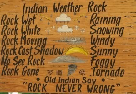
I think the weather guessers should stick to the weather rock method Jim :lol:
Wirelessly posted (MOT-QA30/00.72 UP.Browser/7.2.7.5.610 (GUI) MMP/2.0)
lol, forever-21.
lol, forever-21.
Warbirdhunter
Member
Sounds like CSP is having fun with the big rigs. Some don't know how to put on chains, others have chains that don't fit their truck..Going to be a long night :lol:
CSP and CDOT is where it's at when these storms hit.
On CSP, dunno what TG, heard a semi jackknife on a highway in front of the CSP officer.
On CSP, dunno what TG, heard a semi jackknife on a highway in front of the CSP officer.
Slick Roads in Northern Colorado
Numerous slide offs all around the area, I-25 at MM 251, MM 260, US 34 at MM 67, Hwy 66 and Weld Co road 5, all roads really slick.
CSP has Larimer County on accident alert at this time.
If your out and about slow down and be careful.
73, Rex
Numerous slide offs all around the area, I-25 at MM 251, MM 260, US 34 at MM 67, Hwy 66 and Weld Co road 5, all roads really slick.
CSP has Larimer County on accident alert at this time.
If your out and about slow down and be careful.
73, Rex
jfab
Member
Broomfield County on accident alert. Currently working a multi-car accident at HWY 121 and HWY 287. Also an auto-ped at S 120th st and Dillon Rd.
Click on the link in my signature to be updated on all the happenings in Broomfield on Facebook!
Click on the link in my signature to be updated on all the happenings in Broomfield on Facebook!
Wirelessly posted (MOT-QA30/00.72 UP.Browser/7.2.7.5.610 (GUI) MMP/2.0)
Boulder County is now on accident alert, as of 0200.
Boulder County is now on accident alert, as of 0200.
Snowfall totals
Reports as of 8:00 a.m. Sunday
Idaho Springs 12.5"
Idledale 12.0"
Evergreen 12.0"
Castle Rock 12.0"
Conifer 11.0"
Bailey 10.5"
Kittredge 10.3"
Golden 10.0"
Broomfield 9.9"
Lakewood 9.3"
Littleton 8.5"
Johnstown 8.5"
Highlands Ranch 8.4"
Fort Collins 8.1"
Longmont 7.5"
Denver 7.5"
Westminster 7.0"
Greeley 7.0"
Windsor 7.0"
Loveland 7.0"
Arvada 7.0"
Boulder 7.0"
Strasburg 6.5"
Fairplay 6.0"
Estes Park 5.3"
Thornton 5.0"
New Raymer 5.0"
Louisville 5.0"
Lyons 5.0"
Kiowa 3.8"
Wellington 3.8"
- Status
- Not open for further replies.
Similar threads
- Replies
- 1
- Views
- 497
- Replies
- 9
- Views
- 2K
- Replies
- 24
- Views
- 2K