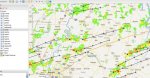
I am with the Placer County (California) Sheriff's Search and Rescue Communications Unit, and we are using software that was created, using Python, developed by a member of our neighboring Nevada County. There are actually two programs that work together, SARtopo.com (there is an offline version of this as well) and Radiolog, available at
https://github.com/ncssar/radiolog . We have installed a TK-7180 in our communications truck and have connected it to our primary dispatch computer to receive FleetSync data. The Radiolog software is what we are using to document all communications during a search. When a unit calls in, it will automatically flag what team the radio calling in on is assigned to and timestamps and geolocates the calling radio. Simultaneously, it sends this location to SARtopo, leaving a "crumb trail" on the map. For those of us in Placer County, what I'm detailing is theoretical but will hopefully become fact this weekend. I am programming our TK-7180 in the truck and 25 TK-2170 portables on Friday. We have, I believe, 12 GPS microphones for the TK-2170 portables. We have a training exercise up in the snow this weekend (there is supposed to be several new feet of snow between now and then).
Because Nevada County and Placer County are neighboring counties, plus we have another SAR organization in Placer County (Tahoe Nordic SAR) and we are all using Nevada County's software (I've modified Radiolog to personalize it for Placer), we are trying to coordinate our Kenwood radios to allow us to work together when mutual aid is required. Each team will be on a different fleet ID and each team will coordinate their own device IDs, but all will set their GPS target to "100-1001." I believe Tuolumne County is also on-board, although there are a couple counties in between us. As we have TK-2170 portables, it looks like it will force everyone to adopt the original FleetSync over FleetSync II... Nevada County has been using TK-2180s that support FleetSync II and have been using it. We are still trying to determine whether we should use 1200 baud or 2400 baud. We are using Caller ID on both BOT and EOT with GPS sending $PKLDS on the EOT as well.
I am hoping for everything to run relatively smoothly as we transition in with this on Saturday.