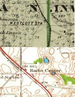
I was looking at the FRA Safety Map today. I entered ZIP code 55068 and then zoomed in. Near the top in red letters it states RADIO CENTER.
What is Radio Center?
What is Radio Center?

Is it a red dot with red text? If so, those are freight stations. Quick googling around I cant find a definitive definition. Sometimes it corresponds to timetable locations and sometimes I have no idea.I was looking at the FRA Safety Map today. I entered ZIP code 55068 and then zoomed in. Near the top in red letters it states RADIO CENTER.
What is Radio Center?
Are the GPS coordinates that are used following any standard? For example, is the LAT and LONG at a crossing the dead center of the intersection or is it much less precise than that?
They are latitudes and longitudes in the format of DEGREES.decimal degrees. Additionally, positive numbers are assumed to be in the northern or eastern hemispheres while negative numbers are assumed to be in the southern or western hemispheres.Are the GPS coordinates that are used following any standard?