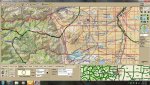
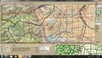
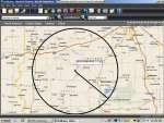
From the WIKI it suggests... "not all geopolitical areas are perfect circles. You can modify the shape of the system by entering multiple sites for the system (even though the system might have only one site) and use different location settings for each site. For example, stack two circles to make a tall, narrow scan area for the system."
Does anyone have a good method for laying out systems like this? I am looking for a map software program, etc. that will let me look at a location on a map and drop a pin or reference point and will draw a radius (circle) and drop a couple other points to make a visual of the tall narrow scan area. Once I have perfected the area I want, I can get all the coordinates for all the reference points and add them as sites in the radio. Anyone got an easy way to do this, or a nice piece of software that allows you to do it? It would be nice if the map went down to the level of showing county, city and town boundries too, so you could make any kind of shape layout needed.
Does anyone have a good method for laying out systems like this? I am looking for a map software program, etc. that will let me look at a location on a map and drop a pin or reference point and will draw a radius (circle) and drop a couple other points to make a visual of the tall narrow scan area. Once I have perfected the area I want, I can get all the coordinates for all the reference points and add them as sites in the radio. Anyone got an easy way to do this, or a nice piece of software that allows you to do it? It would be nice if the map went down to the level of showing county, city and town boundries too, so you could make any kind of shape layout needed.
Last edited: