SDS100/SDS200: GPS setting in SDS200 scanning unwanted system

KAA951

Member
Premium Subscriber
Joined
Sep 9, 2004
Messages
828
Location
Kansas
I recently added a GPS puck to my SDS200 mobile setup. Everything is working well, scanning the services I want EXCEPT- it continues to scan a US Air Force trunk system and shows it is trying to connect to widely spaced towers such as Davis-Monathan in Arizona and Joint Base Fort Dix in New Jersey (I am in Kansas). I have gone into the software and started completely after purging the memory, but this continues to happen.

And, more annoying is that if I “Avoid” the system on the scanner, it simply re-appears once I Move 20 miles or so.

All my nationwide services are set to off. I don’t even know where to look for this US Air Force system in the database to try to remove it that way. Any ideas?
 

phask

Member
Premium Subscriber
Joined
Dec 19, 2002
Messages
3,698
Location
KZZV - SE Ohio

tvengr

Well Known Member
Joined
Feb 10, 2019
Messages
9,410
Location
Baltimore County, MD
It is possible that the distant sites use the same control channel frequencies as your local sites. Go into the scanner menu and set it to Use Site NAC. Are you sure the GPS is working? If you are using the standard Uniden SDS200 GPS where the module plugs directly into the RJ11 jack in the back of the scanner, the baudrate should be set to 9600.
 

rf_patriot200

Member
Joined
Feb 9, 2024
Messages
192
Location
Freeport, Illinois
I recently added a GPS puck to my SDS200 mobile setup. Everything is working well, scanning the services I want EXCEPT- it continues to scan a US Air Force trunk system and shows it is trying to connect to widely spaced towers such as Davis-Monathan in Arizona and Joint Base Fort Dix in New Jersey (I am in Kansas). I have gone into the software and started completely after purging the memory, but this continues to happen.

And, more annoying is that if I “Avoid” the system on the scanner, it simply re-appears once I Move 20 miles or so.

All my nationwide services are set to off. I don’t even know where to look for this US Air Force system in the database to try to remove it that way. Any ideas?
Go into Sentinel and Avoid it permanently, and then send the changes to your 200. They won't come up again.
 

KAA951

Member
Premium Subscriber
Joined
Sep 9, 2004
Messages
828
Location
Kansas
That USAF (57C) is the system! Thanks for the help! I will dig down and permanently avoid it. The GPS seems to be tracking fine on other systems as I travel around- this one is just weird!
 

phask

Member
Premium Subscriber
Joined
Dec 19, 2002
Messages
3,698
Location
KZZV - SE Ohio
Turn off Military maybe. I'm not sure either, I found FT Dix under
United States Air Force (57C) Trunking System, Multiple, Multi-State
but no ranges look excessive.

That USAF (57C) is the system! Thanks for the help! I will dig down and permanently avoid it. The GPS seems to be tracking fine on other systems as I travel around- this one is just weird!
Are you close enough that you can receive the Kansas system? If so, I bet that is what is happening.

What is your range? Less may be better.
 

dave3825

* * * * * * * * * * * *
Premium Subscriber
Joined
Feb 17, 2003
Messages
7,817
Location
Suffolk County NY
Turn off Military maybe.
Davis has Fire and Law service types and Ft Dix has Law, Fire, Emergency ops service types so turning off Military would only avoid that service type but the others will still trigger the sites for scanning.


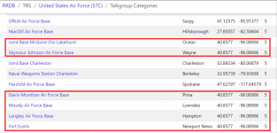
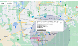
Submit a db requests (since multiple states) asking the departments with a 1500 mile range be reduced to reflect the intended operating area like the rest and supply gps lat and long since the ones with 1500 radius are all using the same coordinates.


Joint Base McGuire-Dix-LakehurstOcean40.8577-96.089061500
Seymour Johnson Air Force BaseWayne40.8577-96.089061500
Joint Base CharlestonCharleston32.89234-80.0687910
Naval Weapons Station CharlestonBerkeley32.95739-79.9365810
Fairchild Air Force BaseSpokane47.62197-117.645795
Davis-Monthan Air Force BasePima40.8577-96.089061500
Moody Air Force BaseLowndes40.8577-96.089061500
Langley Air Force BaseHampton40.8577-96.089061500
Fort EustisNewport News40.8577-96.089061500


If you have an interest in the system, Import it to a fav list, set location to on, and then use either Sentinel or @ProScan and reduce all the inflated ranges and push to the scanner. Thes set the system in the full db to permanent avoid.


1714652803506.png


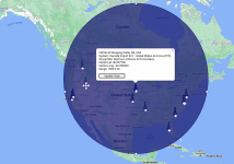
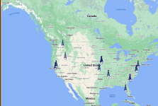
Then it will look like this and should not be a problem.

1714653441447.png
 
Last edited:

ofd8001

Member
Premium Subscriber
Joined
Feb 6, 2004
Messages
7,942
Location
Louisville, KY
The GPS/GPS puck component is working as it should be. It is updating your scanner's current location every so often. The scanner then "reaches out" to monitor all the systems having a coverage footprint overlapping where your scanner believes it is.

The issue is that the database has that huge range as noted above and the noted solution is correct.
 

dave3825

* * * * * * * * * * * *
Premium Subscriber
Joined
Feb 17, 2003
Messages
7,817
Location
Suffolk County NY
So it looks like the ranges have all been fixed.

1714683889014.png


I made a post in Multi State forum in hopes of people submitting the correct gps data since these 6 have data reflecting somewhere in Nebraska.


. 1714685209001.png
 

phask

Member
Premium Subscriber
Joined
Dec 19, 2002
Messages
3,698
Location
KZZV - SE Ohio
Davis has Fire and Law service types and Ft Dix has Law, Fire, Emergency ops service types so turning off Military would only avoid that service type but the others will still trigger the sites for scanning.


Submit a db requests (since multiple states) asking the departments with a 1500 mile range be reduced to reflect the intended operating area like the rest and supply gps lat and long since the ones with 1500 radius are all using the same coordinates.


Joint Base McGuire-Dix-LakehurstOcean40.8577-96.089061500
Seymour Johnson Air Force BaseWayne40.8577-96.089061500
Joint Base CharlestonCharleston32.89234-80.0687910
Naval Weapons Station CharlestonBerkeley32.95739-79.9365810
Fairchild Air Force BaseSpokane47.62197-117.645795
Davis-Monthan Air Force BasePima40.8577-96.089061500
Moody Air Force BaseLowndes40.8577-96.089061500
Langley Air Force BaseHampton40.8577-96.089061500
Fort EustisNewport News40.8577-96.089061500


If you


Then it will look like this and should not be a problem.
Dave can you show a link where that range is? All I found was the 5 mile. I never found it in Sentinel - but didn't look that hard.

EDIT - found it, I used the NJ location, eaier to find.
Couldn't the OP also just avoid the United States Air Force (57C) - in any of the states entries and be done also.
I agree the DB needs corrected, but maybe someone though it needed US wide coverage because that is what it is (more or less).
 
Last edited:

Randyk4661

Active Member
Premium Subscriber
Joined
Jun 27, 2019
Messages
512
Location
Garden Grove, CA
As a user of the GPS, You need to fine tune every system you want to listen to or otherwise you will get far more than what you want to listen to.
Shorten the ranges to fit what they actually cover and not the entire county, state, nation as in the database.
After lots of work doing this, GPS scanning is worth the extra work.
I use proscan to do the editing of GPS areas.
 

dave3825

* * * * * * * * * * * *
Premium Subscriber
Joined
Feb 17, 2003
Messages
7,817
Location
Suffolk County NY
Couldn't the OP also just avoid the United States Air Force (57C) - in any of the states entries and be done also.

Yes he can. But for anyone else trying to gps on a trip, they will have their scanners trying to latch on if they have military, law, fire or emergency ops service types enabled.
 

ofd8001

Member
Premium Subscriber
Joined
Feb 6, 2004
Messages
7,942
Location
Louisville, KY
As a user of the GPS, You need to fine tune every system you want to listen to or otherwise you will get far more than what you want to listen to.
Shorten the ranges to fit what they actually cover and not the entire county, state, nation as in the database.
After lots of work doing this, GPS scanning is worth the extra work.
I use proscan to do the editing of GPS areas.
Will ProScan allow editing of the full database, or would the user need to build Favorites Lists? If ProScan does, can you point me to where this would be?
 

dave3825

* * * * * * * * * * * *
Premium Subscriber
Joined
Feb 17, 2003
Messages
7,817
Location
Suffolk County NY
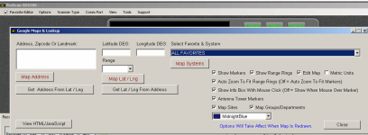
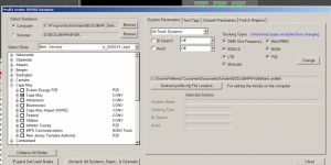
Proscan can edit the full database but I believe what Randy spoke of was done via favorite lists using google maps lookup.

1714730897318.png

1714731913186.png


1714732005392.png


Modify full db is further down but I did not see anything for gps ranges.

1714731827381.png
 

Randyk4661

Active Member
Premium Subscriber
Joined
Jun 27, 2019
Messages
512
Location
Garden Grove, CA
What Dave3825 said^(y)

GPS Editing is done under both "Sites" & "Department" using the location tab under each.
Sites are for the transmitter coverage area and departments is for the agency coverage area. You need to do both.
Use the google maps tab to fine tune the ranges.
If you use a circle range you can only have one, but if you use the rectangles range you can have more than one to cover oddly shaped areas.

When starting a GPS favorite list, I use Google earth (any GPS location program will work) to get starting coordinates. Enter those into Proscan then use the google maps tab in Proscan to fine tune the ranges by sliding the circle or boxes to better fit. I have one circle center point over the ocean to cover a beach town along the coast to properly cover the city limits.

Use the update node button often!

SAVE YOUR WORK OFTEN!. File tab / Save option. Nothing worse to find out you didn't save and having to redo everything.

And lastly, MAKE backup SD cards to have when you are mobile or just to keep at home.
 
Top