I've been playing around with satellites this past week.. had some issues with the Amateur radio satellites in that I can't decode anything from them.. (still working on that from my other thread).. But tonight I decided to give the NOAA satellites a shot.
I'm using an RTL-SDR dongle hooked to 100 feet of RG8/U coax running into a G5RV Dipole antenna strung up about 55 feet into a tree.. Ya. that's not a typo.. a G5RV that was originally intended to operate on the 10 to 40 meter bands...
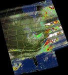
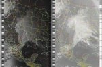
And it worked! Sort of... kind of... I don't know how clear the signal is supposed to be but I started recording about 20 seconds after it entered range and it had just finished (barely) about 20 seconds before the satellite went out of range.. The sat was at an elevation of 24 degrees.. It seems that I downloaded a single image but in 5 formats. I have MCIR, NO, Contrast, Contrast, and Norm
The picture is not perfect and there are some goofy lines of static in it, but I can clearly see the clouds, my state, major bodies of water, etc. THAT was cool..
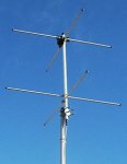
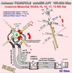
I think I'm going to build one of those double cross dipole antenna's and maybe purchase a band-pass antenna preselector (was recommended) to get rid of some of the noise the dongle picks up.
I'm not sure if I've figured this all out yet, but are these NOAA satellites in some kind of train behind each other so the software will stack images from multiple satellites? Or do they become totally separate instances? Seems to me that I got a hold of the caboose because there were no more due for another 7 or 8 hours or so.
I'm using an RTL-SDR dongle hooked to 100 feet of RG8/U coax running into a G5RV Dipole antenna strung up about 55 feet into a tree.. Ya. that's not a typo.. a G5RV that was originally intended to operate on the 10 to 40 meter bands...
And it worked! Sort of... kind of... I don't know how clear the signal is supposed to be but I started recording about 20 seconds after it entered range and it had just finished (barely) about 20 seconds before the satellite went out of range.. The sat was at an elevation of 24 degrees.. It seems that I downloaded a single image but in 5 formats. I have MCIR, NO, Contrast, Contrast, and Norm
The picture is not perfect and there are some goofy lines of static in it, but I can clearly see the clouds, my state, major bodies of water, etc. THAT was cool..
I think I'm going to build one of those double cross dipole antenna's and maybe purchase a band-pass antenna preselector (was recommended) to get rid of some of the noise the dongle picks up.
I'm not sure if I've figured this all out yet, but are these NOAA satellites in some kind of train behind each other so the software will stack images from multiple satellites? Or do they become totally separate instances? Seems to me that I got a hold of the caboose because there were no more due for another 7 or 8 hours or so.