You are using an out of date browser. It may not display this or other websites correctly.
You should upgrade or use an alternative browser.
You should upgrade or use an alternative browser.
ISICS Tower Site Map
- Thread starter TrevorMollenbeck
- Start date
- Status
- Not open for further replies.
baker50021
Member

Iowa Statewide Interoperability Communications System Board (ISICSB)
The ISCIS Board provides the highest level of standardized interoperable public safety and public service communications in accordance with the Code of Iowa.
TrevorMollenbeck
Member
I have looked at that one before and use it the most it seems to missing some sites though. Like the one on the Lucas State office building I see it is missing. Which is weird to me it’s not on there.
wn0r
Member
Try this one, I posted this
Jul 20, 2019
it's from the FCC database, it doesn't have all the newer ones but you can see it better
Iowa Statewide Interoperability Communication System (ISICS) | Page 16 | RadioReference.com Forums
Jul 20, 2019
it's from the FCC database, it doesn't have all the newer ones but you can see it better
Iowa Statewide Interoperability Communication System (ISICS) | Page 16 | RadioReference.com Forums
You can zoom in on this one and read it.

After taking a look at most of the sites licenses the version I make wont be any different from this one: Site Map: Iowa Statewide Interoperable Communications System (ISICS) Trunking System, Statewide, Multi-State Due to the fact the same FCC license is listed for most of the licenenses in the database.
TrevorMollenbeck
Member
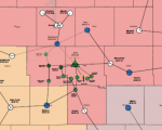
Here is a better screenshot than the one I took on my phone. The sites that really interest me is how this map shows so many sites around Des Moines and how all of the other maps I have found seem to be lacking those sites. Looks like there are several sites in Polk and Dallas county. I'd like to be able to see the names of the sites but the image is too blurry to read all of them. The one at JFHQ is the only one I can make out.

It's a simulcast "site" which is why maps mostly show it as one site. This most recent map you posted shows the backhaul path which is why it shows individual RF or microwave hop sites.
VASCAR2
Member
If you go to the database for ISICS click on the DeMoines Simulcast site. A page will show the individual simulcast sights. There is a description or address for each site and a abbreviation for the structure, Tank, Tower, Building or other tall structure. Below the map list the frequencies and the gps longitude and latitude coordinates for each site. You can copy the long/lat into google earth and look at the sight. Many times you can see the individual antennas and microwave dishes using the street view.
Here is a link to the page I was referencing.

Here is a link to the page I was referencing.
FCC Callsign WPKQ759 (CITY OF WEST DES MOINES)
FCC Callsign WPKQ759 (CITY OF WEST DES MOINES)
www.radioreference.com
Des Moines likely has a higher grade of service requirement since it is an urban area. They probably have a portable radio on-street / light structure requirement, whereas the state's grade of service requirement is mobile on street coverage - a requirement that can be met with fewer tower sites.Here is a better screenshot than the one I took on my phone. The sites that really interest me is how this map shows so many sites around Des Moines and how all of the other maps I have found seem to be lacking those sites. Looks like there are several sites in Polk and Dallas county. I'd like to be able to see the names of the sites but the image is too blurry to read all of them. The one at JFHQ is the only one I can make out.View attachment 104484
- Status
- Not open for further replies.
Similar threads
- Replies
- 20
- Views
- 958
- Replies
- 5
- Views
- 583
- Replies
- 1
- Views
- 402


