Dave_D
Member
Hi all,
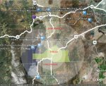
Does anyone agree that location-based scanning would be improved if scanners permitted polygonal definition of scanning areas? By this, I mean that the location of a programmed system would be defined by its corners, a multitude of lat/long points, rather than the popular point/radius method.
BENEFITS
CONS
Just some idle thoughts from a scanner newb....
Am I plumb loco?
Does anyone agree that location-based scanning would be improved if scanners permitted polygonal definition of scanning areas? By this, I mean that the location of a programmed system would be defined by its corners, a multitude of lat/long points, rather than the popular point/radius method.
BENEFITS
- Accuracy of location boundaries (e.g., counties) is drastically improved
- Description of over-sized or awkwardly-shaped counties is simplified
- Reduces or elliminates overlapping among neighboring, conflicting system areas
- Locations of radio towers need not be known
- Reception areas can factor geographic features (e.g., mountains)
- A single location can accomodate one or more simulcast sites
- With more accurate location boundaries, scanner users would receive fewer unwanted signals from neighboring locations.
- Resolves problem of duplicating entire system programs to describe location by two or more points.
- Supports areas of unlimited size; locations need not be limited to arbitrary radii.
CONS
- CPU overhead required to track position among polygonal areas is greater
- At first blush, programming 3+ points would appear to require more effort from scanner users (though I would argue that placing and sizing those gosh-darned circles isn't any easier, being that most counties are more-or-less squareish).
- This approach would constitute a competing standard. Portability of location data between point-based and polygonal location-based scanners might be a problem.
Just some idle thoughts from a scanner newb....
Am I plumb loco?