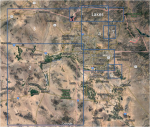
MCSO Map

Status
Not open for further replies.

radiochuck

Traffic Reporter
Premium Subscriber
Joined
Mar 5, 2013
Messages
468
Location
Phoenix, AZ
Now that I've finally gotten around to getting a GPS add-on for my HP-1, I'd really like to take full advantage of that functionality.

I programmed in a bunch of rectangles for DPS and they seem to work very well. I'm hoping to do the same for MCSO, but can't seem to find a map that shows the boundaries between, east central, west, etc. I'm hoping someone can point me in the right direction, so I can get that programmed.

Thanks in advance.
 

radiochuck

Traffic Reporter
Premium Subscriber
Joined
Mar 5, 2013
Messages
468
Location
Phoenix, AZ
Thanks, John. I have that info. Just wondering if someone had a map, before I embark on another project of translating that info into GPS coordinates.
 

KB7MIB

Member
Joined
Aug 17, 2003
Messages
4,195
Location
Peoria, AZ.
There is an old map in the Southwest Frequency Directory, 10th Edition, that was published in 2009.
I don't know if anyone ever scanned it online.

John
Peoria
 

Phoenix805

Member
Joined
Aug 1, 2009
Messages
481
Location
NW Phoenix and NW Ohio
I dusted off my old Southwest Frequency Directory and found the map. Unfortunately it looks like a scan of a scan and is pretty bad to start with. There is a notation that says: "The beats below are left without precise boundaries as the boundaries for MCSO patrol are not as rigid as other municipal police departments." The map doesn't really show any dividing lines, it basically just says 1- SE, 2- SW, 3- NW, 4-NE, 6- Queen Creek area, and 7- Fountain Hills.

I tried making my own map from the Sheriff's web site a few years ago but some of the info didn't seem to jive, but it may be better than nothing. I'll see if I can upload it. Essentially 1 is east of the I-17 alignment and south of Indian School. 2 is west of I-17 and south of Northern. 3 is west of I-17 and north of Northern, 4 is east of I-17 and north of Indian School. Lakes is far north roughly including Lake pleasant and everything north of Carefree Highway.

1555017555651.png
 

radiochuck

Traffic Reporter
Premium Subscriber
Joined
Mar 5, 2013
Messages
468
Location
Phoenix, AZ
That's great info, Phoenix805. Thank you! I'm just looking for something to setup some GPS boundaries, so it doesn't have to be exact.

Sent from my Pixel 3 XL using Tapatalk
 

KB7MIB

Member
Joined
Aug 17, 2003
Messages
4,195
Location
Peoria, AZ.
I believe Lakes includes all of the recreational lakes: Apache, Bartlett, Horeshoe, Pleasant, Roosevelt, etc., as well as the Salt River Recreation area, and I also believe AZ 87 from Shea Blvd to the Gila County line. I've heard Tonto NF LEO's patrolling 87 on the Lakes TG.

John
Peoria
 

Phoenix805

Member
Joined
Aug 1, 2009
Messages
481
Location
NW Phoenix and NW Ohio
I believe Lakes includes all of the recreational lakes: Apache, Bartlett, Horeshoe, Pleasant, Roosevelt, etc., as well as the Salt River Recreation area, and I also believe AZ 87 from Shea Blvd to the Gila County line. I've heard Tonto NF LEO's patrolling 87 on the Lakes TG.

John
Peoria
That would make sense, and it would also help explain why the east edge of district 4 doesn't go east to the border.
 

Phoenix805

Member
Joined
Aug 1, 2009
Messages
481
Location
NW Phoenix and NW Ohio
<laughing> I also just noticed that I have '1' down by Gila Bend & Coolidge. They're not in Maricopa County. The '1' should be up in the small box with Mesa, Gilbert, and Chandler. Like I said, it's not a great map and my straight lines don't follow the crooked boarders, but it gives an idea where things are. Maybe I'll upgrade it one of these days - or maybe not.
 

clover509

Member
Joined
Feb 24, 2007
Messages
166
It has been my experience that the bulk of traffic on Central is civil process service and is heard at addresses as far out as Gila Bend and Queen Creek. Kind of a misnomer to be called Central when it appears to be used county-wide.

Also, other than to differentiate the East and West areas of operation if you were mobile with your HP-1, being as there are only two areas and the TGIDs aren't broken down more specifically like say, Phoenix PD 200 Precinct, etc, I am just wondering why a clear map of the different patrol areas for coordinates would help the GPS operation.

I have my 436 setup for very specific boundaries on RWC with Phoenix as I transit from north to south in Phoenix. MCSO is pretty broad on its East, West, Lakes boundaries by contrast. Just a difference in preference of scanning, I suppose. :)
 

radiochuck

Traffic Reporter
Premium Subscriber
Joined
Mar 5, 2013
Messages
468
Location
Phoenix, AZ
Also, other than to differentiate the East and West areas of operation if you were mobile with your HP-1, being as there are only two areas and the TGIDs aren't broken down more specifically like say, Phoenix PD 200 Precinct, etc, I am just wondering why a clear map of the different patrol areas for coordinates would help the GPS operation.

I'd just like to have a mental picture of the geographical layout of the agency and its radio assignments, before I program the radio.


Sent from my Pixel 3 XL using Tapatalk
 
Status
Not open for further replies.
Top