My ADS-B Coverage Map

Status
Not open for further replies.

vagrant

ker-muhj-uhn
Premium Subscriber
Joined
Nov 19, 2005
Messages
3,177
Location
California
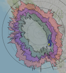
Using Virtual Radar Server, one can have it build up a coverage map over a short time. There is a box to check and location information that needs to be entered in on the server, but give it a whirl and see your coverage range and altitudes at distances. I only recently stumbled across this feature, as I was previously using Plane Finder to view a plot on a map.

The range rings on my map are at 50 nautical miles. Starting from the inner area the altitude plots in feet are from 0-9.9k, 10k-19.9k, 20k-29.9k, 30k and above. I'm using a DPD Productions outdoor ADS-B antenna that is up about nine meters (30') and uses RG-6 coaxial cable. Yep, 50 feet of RG-6.

Click the thumbnail to enlarge.
Screen Shot 2020-06-19 at 8.26.36 PM.png
 

vagrant

ker-muhj-uhn
Premium Subscriber
Joined
Nov 19, 2005
Messages
3,177
Location
California
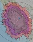
Here is an update to my map. After running for two months, and more aircraft flying, the range has slightly extended. The interesting bit for me, and I am speculating at this point, is the reduced RX signal west of my location, and especially WSW with the large reduced coverage curve. A maple tree on my property has very large leaves in that WSW direction. Also, due west is a large Ash tree that is taller and wider with smaller leaves. I will update again in December or January once the leaves have fallen to see if the difference is the tree leaves. The reduction in coverage is rather clear starting at 0-10k feet and it continues to be noticeable where both of those trees are. The Ash tree due west is 65' away and the Maple is 50' WSW. I tested the chance of a null due to the antenna by turning the mast.

Many already understand how tree leaves can interfere with radio signals, especially at higher frequencies, leaf size and overall canopy. My first experience of this was in the 90's using a handheld Garmin GPS while in the Sierra Nevada range due to the pine trees. Recently, while using an Icom IC-SAT100 Iridium radio I was not surprised with the the loss of coverage due to foliage.

The reduced coverage line to the east from north to south is due to the Sierra Nevada mountains.
Screen Shot 2020-08-26 at 3.24.34 PM.png
 

Reconrider

Active Member
Joined
Sep 26, 2017
Messages
1,756
Location
EST
Here is an update to my map. After running for two months, and more aircraft flying, the range has slightly extended. The interesting bit for me, and I am speculating at this point, is the reduced RX signal west of my location, and especially WSW with the large reduced coverage curve. A maple tree on my property has very large leaves in that WSW direction. Also, due west is a large Ash tree that is taller and wider with smaller leaves. I will update again in December or January once the leaves have fallen to see if the difference is the tree leaves. The reduction in coverage is rather clear starting at 0-10k feet and it continues to be noticeable where both of those trees are. The Ash tree due west is 65' away and the Maple is 50' WSW. I tested the chance of a null due to the antenna by turning the mast.

Many already understand how tree leaves can interfere with radio signals, especially at higher frequencies, leaf size and overall canopy. My first experience of this was in the 90's using a handheld Garmin GPS while in the Sierra Nevada range due to the pine trees. Recently, while using an Icom IC-SAT100 Iridium radio I was not surprised with the the loss of coverage due to foliage.

The reduced coverage line to the east from north to south is due to the Sierra Nevada mountains.
View attachment 90527
What program gives you that graph? I want to see what mine is getting
 
Status
Not open for further replies.
Top