Maybe someone can help me with this.
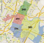
I am trying to get a better feel for the breakdown of the Newark PD Precincts and what specific areas they cover. I was looking for a map that would outline the areas of jurisdiction for each of the precincts, similar to what is available for the NYPD. But I have not been able to come across one, so I've created one myself (see attatchment).
Using information from newarkpd.org, wikipedia, and google maps, I've tried to outline each precinct in Photoshop. I wonder if there is anyone out there who could better confirm the boundaries of each area and confirm the information I've come across.
It appears that:
2ND Precinct starts with 280 in the south and then runs north, east, and west to the boundaries of Newark itself.
4TH Precinct starts with 280 in the north, west to the Oranges, south to Hawthorne avenue, and the eastern border is University Avenue & Dr. MLK BLVD south to Macarthur Highway.
5TH Precinct starts with Hawthorne Ave in the north, south and west to the boundaries of Newark itself, and east to the airport. According to the NewarkPD website, the South Broad Valley, which is the weird part of the map that I have coming out to the NE corner of 5TH Precinct, running up Macarthur HWY to Lincoln Park.
3RD Precinct runs east from all of these to the bay.
Could someone who has a little more knowledge of the Newark system help me out a bit and tell me if I have this approximately correct?
Thanks.