• To anyone looking to acquire commercial radio programming software:

    Please do not make requests for copies of radio programming software which is sold (or was sold) by the manufacturer for any monetary value. All requests will be deleted and a forum infraction issued. Making a request such as this is attempting to engage in software piracy and this forum cannot be involved or associated with this activity. The same goes for any private transaction via Private Message. Even if you attempt to engage in this activity in PM's we will still enforce the forum rules. Your PM's are not private and the administration has the right to read them if there's a hint to criminal activity.

    If you are having trouble legally obtaining software please state so. We do not want any hurt feelings when your vague post is mistaken for a free request. It is YOUR responsibility to properly word your request.

    To obtain Motorola software see the Sticky in the Motorola forum.

    The various other vendors often permit their dealers to sell the software online (i.e., Kenwood). Please use Google or some other search engine to find a dealer that sells the software. Typically each series or individual radio requires its own software package. Often the Kenwood software is less than $100 so don't be a cheapskate; just purchase it.

    For M/A Com/Harris/GE, etc: there are two software packages that program all current and past radios. One package is for conventional programming and the other for trunked programming. The trunked package is in upwards of $2,500. The conventional package is more reasonable though is still several hundred dollars. The benefit is you do not need multiple versions for each radio (unlike Motorola).

    This is a large and very visible forum. We cannot jeopardize the ability to provide the RadioReference services by allowing this activity to occur. Please respect this.

Online software for line of sight

Enforcer52

Feed Provider
Feed Provider
Joined
Sep 4, 2023
Messages
378
Location
Lake Livingston, TX
Does it have earth curvature

This one calculates curvature by distance and height, but think you have to combine the answer you are looking for
 

Enforcer52

Feed Provider
Feed Provider
Joined
Sep 4, 2023
Messages
378
Location
Lake Livingston, TX
Using the earth curvature calculator my distance to the tower in Huntsville, Tx is 23 miles, my antenna is at 18 feet, Huntsville antenna at 189 feet, the lowest point I can see is 211.403 feet, therefore I use a yagi antenna for my inside scanner on 800mhz.
 

Enforcer52

Feed Provider
Feed Provider
Joined
Sep 4, 2023
Messages
378
Location
Lake Livingston, TX
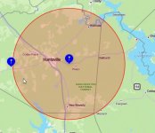
The surrounding area includes parts of the Sam Houston National Forest and is heavily forested. The Huntsville tower only has a radius of 30 miles, so 15 miles in any direction. My location on the attached map is the red dot on the west side of Lake Livingston. So you can see being on the fringe and all the trees really knocks down the signal, hence the yagi.
 

Attachments

  • Huntsville Tower.jpg
    Huntsville Tower.jpg
    28.3 KB · Views: 8

KF0NYL

Member
Joined
Oct 20, 2023
Messages
76
Radius is equal to half the diameter of a circle. So if the radius is 30 miles then the diameter (total coverage) is 60 miles. So technically speaking two radios that are 30 miles from the repeater tower in opposite directions will be 60 miles apart.
 

Enforcer52

Feed Provider
Feed Provider
Joined
Sep 4, 2023
Messages
378
Location
Lake Livingston, TX
Radius is equal to half the diameter of a circle. So if the radius is 30 miles then the diameter (total coverage) is 60 miles. So technically speaking two radios that are 30 miles from the repeater tower in opposite directions will be 60 miles apart.
You are right, I should have put a radius of 15 miles for a diameter of 30 miles, which is the correct distance. I am 8 miles outside that radius of 15 miles.
 

KF0NYL

Member
Joined
Oct 20, 2023
Messages
76
You are right, I should have put a radius of 15 miles for a diameter of 30 miles, which is the correct distance. I am 8 miles outside that radius of 15 miles.
You most likely won't get into the repeater with a HT or mobile. There is a good chance that you can get into the repeater with a base station and a good antenna with enough height and a clear line of sight.

There is a GMRS repeater 33 miles away from me and I am 14 miles outside of its range. I can sometimes get into it with my 50 watt base station depending on atmospheric conditions. My GMRS antenna base is 20 foot above ground.

And sometimes even if you are within the repeater's range, you might be able to hear the repeater but have a hard time reaching it while transmitting with a 5 watt HT.

My local repeater tower is 21.5 miles from my house which currently has 2m and 70cm repeaters. The 2m repeater has a 80 mile radius and I can get in with a 5 watt HT with no problems. I am not sure on the 70cm repeater radius but I cannot get into it at all with my 5 watt HT. The tower is 900 foot tall.
 

KF0NYL

Member
Joined
Oct 20, 2023
Messages
76
Yes I missed the part about a scanner Mods can delete my long winded reply (#10) if they want to
 

dickie757

Wired
Joined
Apr 25, 2017
Messages
426
Location
Out of range
@nd5y I did one like that...Mt. Spokane to Grey Butte in Oregon. No curve. I will edit this post with a known good curvature app from ubiquiti.

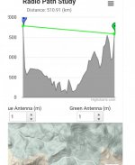
Of course it was years ago, but I found a los calculator that included distance of a heading off a peak or point to the horizon. The path I mentioned was 359ish miles, Grey has a 110ish mile horizon, and Mt. Spokane has 100ish mile to horizon. Curve accounted for missing 149 miles.

Here we are....
 
Top