Potential Severe/Tornado Outbreak 5-10!

Status
Not open for further replies.

peterjmag

Member
Joined
Dec 14, 2001
Messages
2,023
Location
Tulsa, OK
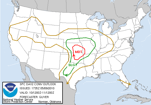
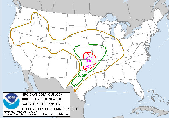
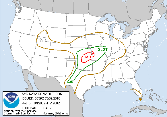
Storm Prediction Center May 9, 2010 0600 UTC Day 2 Convective Outlook

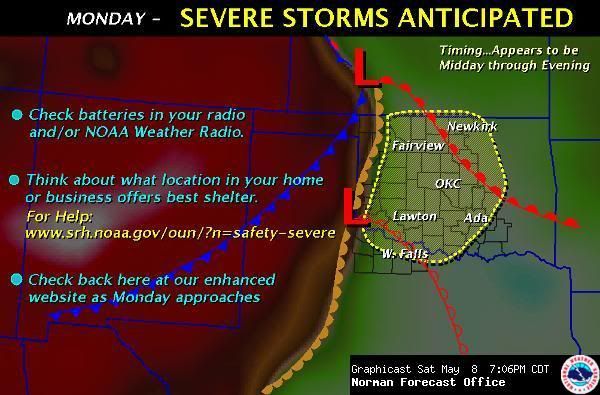
Will be spotting from the Stillwater area...

Be careful out there...

day2otlk_0600.gif


fxc_Hazardous_Weather_Outlook.jpg
 
Last edited:

mancow

Member
Database Admin
Joined
Feb 19, 2003
Messages
6,880
Location
N.E. Kansas
Sweet...It's about time. It's the only thing this part of the country is known for so I say let's get it on.
 

peterjmag

Member
Joined
Dec 14, 2001
Messages
2,023
Location
Tulsa, OK
Yeah it's looking real nasty. People should take it very seriously. This event has the potential to very dangerous...
 

mancow

Member
Database Admin
Joined
Feb 19, 2003
Messages
6,880
Location
N.E. Kansas
They mentioned baseball sized hail. Maybe I'm not wanting any part of that after all. :eek:
 

redhelmet13

Member
Joined
Aug 5, 2003
Messages
459
Location
4 nm se KNFW
Storms will be moving FAST. 45MPH or so. They will be impossible to outrun in a metro area. This has the potential to be a Particularly Dangerous Situation. Expect to see PDS watches today.
I wont bother to chase these since the speed of the storms is so rapid. Too dangerous for me.
Spotters and chasers please be extra careful and stay safe.
 

SCPD

QRT
Joined
Feb 24, 2001
Messages
0
Location
Virginia
Thank goodness there was nothing on TV tonight. Fannin Co [TX] ARES Chased (myself included) these as they came out of Bryan Co. into North Texas. We got some GREAT pictures of a Nasty rotating wall with lowering's over NW Fannin Co. Condolences to y'all in OK for a devastating Evening. Oklahoma will recover, Y'all always do. Folks in Oklahoma affected by these are in my prayers tonight.
 
Status
Not open for further replies.
Top