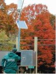
River monitor

Status
Not open for further replies.

ALBC785

Member
Joined
Aug 18, 2006
Messages
80
Location
Hokes Bluff Alabama
I have notice that along major rivers these buildings with cross polarized UHF antenna on them. I know they are used to monitor river levels, I was wondering if anyone might have information on what frequency(s) they may use and what sat are they transmitting to?
 

Attachments

  • sat.JPG
    sat.JPG
    10.6 KB · Views: 512

ecps92

Member
Joined
Jul 8, 2002
Messages
14,407
Location
Taxachusetts
Try here "IFLOWS" for some info, unfortunately Alabama is not part of the site....

I have notice that along major rivers these buildings with cross polarized UHF antenna on them. I know they are used to monitor river levels, I was wondering if anyone might have information on what frequency(s) they may use and what sat are they transmitting to?
 

ItsLittlePD

Member
Joined
Feb 7, 2010
Messages
1
Water Monitoring ....

Funny you mention that -- as I've been wondering the same thing as I been M/C riding the backroads and coming across dozens of these systems over the past few years .......

And .......

Attached is a screenshot of some of the (many) carriers I've observed at the high end of 299 Mhz. At least several of them are FM Modulated by some sensors it seems, while some have uber-slow data....

I've been wondering if these carriers are from analog water monitors......

Perhaps I'm looking in the wrong places but I can't seem to find data on these carriers
 

Attachments

  • 299.99 Mhz.jpg
    299.99 Mhz.jpg
    66.7 KB · Views: 465

ALBC785

Member
Joined
Aug 18, 2006
Messages
80
Location
Hokes Bluff Alabama
Funny you mention that -- as I've been wondering the same thing as I been M/C riding the backroads and coming across dozens of these systems over the past few years .......

And .......

Attached is a screenshot of some of the (many) carriers I've observed at the high end of 299 Mhz. At least several of them are FM Modulated by some sensors it seems, while some have uber-slow data....

I've been wondering if these carriers are from analog water monitors......

Perhaps I'm looking in the wrong places but I can't seem to find data on these carriers

I have been looking at the information that ecps92 posted and it has been very interesting. It looks like the sites transmit in the 401 - 403 Mhz area and if they transmit to GOES it is downlink around 1691 Mhz in a TDMA format.
 

Kfred

Member
Joined
Sep 16, 2007
Messages
87
Location
Early, TX
river monitor

This looks a lot like the ones that have shown up in and around brownwood TX. The antenna looks the same but most of these are close to the highway no where near water, these have a rain gauge and barometric pressure sensor. I have seen this type of antenna on river monitors inside small buildings and could here the NWS audio coming from inside, and thought the data was used by the national weather service for current weather condition reporting. kfred.
 

rdale

Completely Banned for the Greater Good
Premium Subscriber
Joined
Feb 3, 2001
Messages
11,380
Location
Lansing, MI
also try weather.gov under rivers and streams they cover almost all of the us including Alabama

That doesn't include any of the frequency info though... That's what he was looking for - not the actual data.
 
Joined
Jun 7, 2006
Messages
44
Location
Dorset, South UK
Hi,

It would appear that 'GOES' satellites have receivers for the following freqs;

401.700 @ 4KHz b/w
401.850 @ 4KHz b/w
406.025 @ 3KHz b/w
406.028 @ 3KHz b/w
406.050 @ 3KHz b/w
2033.000 @ 60KHz b/w

Any transmits on some / all of the following; (MHz)

468.8125
468.8250
468.8375
1544.5 (sarsat package see ww.uhf-satcom.com/lband/sarsat/)
1676
1681.478
1685.7
1690.725
1691
1692.7
1694
1694.3
1694.45
1694.5
1694.8
and S-Band TTC on 2208.586 and/or 2209.086

regards

Paul
uhf-satcom.com
 
Status
Not open for further replies.
Top