Programming Region A-MA into my scanners. Anyone have recommendations on range setting? It defaults to 165 miles. Not sure if I have to leave it there or how many sites would be on. Only concerned with a 4 county area.

You are using an out of date browser. It may not display this or other websites correctly.
You should upgrade or use an alternative browser.
You should upgrade or use an alternative browser.
Statewide Mutual Aid
- Thread starter mr10pt
- Start date
- Status
- Not open for further replies.
SWMA's are STATE WIDE MUTUAL AID TG's thus the setting is for the entire State. Regionals once I can figure out a usable range setup as the system does circles for ranges, I will break them down. Currently the range circles would not really work right and cause just as many overlap issues as the current settings. If we can get hexagon type range boxes set up right in the system then I can "block" in the areas much better. As for doing it with an GPS puck and your scanner, I would lock it in more like an 50 to 75 mile range in a circle of the 4 counties?
Actually I used the default range setting for Regional Mutual Aid for a test. It did not include the entire state (thank god). It appears to have included 1 or 2 extra sites which I can live with or avoid individually as needed. Region "A"-MA is used (here) primarily for inbound helicopters to ground comms. It was also used for a large fire scene at Shaffer Generating Plant (Nipsco/Wheatfield) as an Ops channel where multiple jurisdictions and counties were involved. Today, on AMA1, it was used for Porter County contacting ISP Lowell regarding a 10-50 rollover on 94. Don't know of a "region map" but would be interesting to see. Seems like the sites are controlled by region so I would stick with the default setting as per the "site handshake agreement" which has been explained to me in a different post. Thanks for the response and input. Just started hearing the "A"-MA within the last couple of months. Regional Mutual Aid can be found on the Safe-T network. Scroll down alphabetically.SWMA's are STATE WIDE MUTUAL AID TG's thus the setting is for the entire State. Regionals once I can figure out a usable range setup as the system does circles for ranges, I will break them down. Currently the range circles would not really work right and cause just as many overlap issues as the current settings. If we can get hexagon type range boxes set up right in the system then I can "block" in the areas much better. As for doing it with an GPS puck and your scanner, I would lock it in more like an 50 to 75 mile range in a circle of the 4 counties?
west-pac
Member
- Joined
- Nov 13, 2004
- Messages
- 1,574
Actually I used the default range setting for Regional Mutual Aid for a test. It did not include the entire state (thank god). It appears to have included 1 or 2 extra sites which I can live with or avoid individually as needed. Region "A"-MA is used (here) primarily for inbound helicopters to ground comms. It was also used for a large fire scene at Shaffer Generating Plant (Nipsco/Wheatfield) as an Ops channel where multiple jurisdictions and counties were involved. Today, on AMA1, it was used for Porter County contacting ISP Lowell regarding a 10-50 rollover on 94. Don't know of a "region map" but would be interesting to see. Seems like the sites are controlled by region so I would stick with the default setting as per the "site handshake agreement" which has been explained to me in a different post. Thanks for the response and input. Just started hearing the "A"-MA within the last couple of months. Regional Mutual Aid can be found on the Safe-T network. Scroll down alphabetically.
Attachments
Thanks!
I don't find the concern over the ranges of the talk groups, am I missing something? I could set the range of A-MA1 to 500 miles, it's never going to show on any site in the southeast part of the state and it's never going to affect the # of sites scanned. The same goes for county talk groups, why have the talk group range so small, they could be set to 50 miles (for example). It's not going to make the scanner scan extra sites + 90% of the time the more distant talk group isn't going to affiliate with the local site anyway.
What really slows down the scanner is the excessive ranges on the actual sites. Using gps coordinates (near Versailles) with range at 0.0, using the unmodified SafeT database entry, I'm scanning 13 sites. With the Remtronix ant on a 436, I receive 3 or 4 sites. It's a little better with an external ant, but still scans several sites that are out of range. Makes no sense to have the db setup so that it's causing the scanner to waste time scanning an all the extra sites. I have corrected this in my fav list with the help of notepad, but it would be nice if I could just update directly from the database (using append) instead of having to fix it with notepad or manually update it.
What really slows down the scanner is the excessive ranges on the actual sites. Using gps coordinates (near Versailles) with range at 0.0, using the unmodified SafeT database entry, I'm scanning 13 sites. With the Remtronix ant on a 436, I receive 3 or 4 sites. It's a little better with an external ant, but still scans several sites that are out of range. Makes no sense to have the db setup so that it's causing the scanner to waste time scanning an all the extra sites. I have corrected this in my fav list with the help of notepad, but it would be nice if I could just update directly from the database (using append) instead of having to fix it with notepad or manually update it.
When I was still a admin, as we got proper range data I updated the sites. TG ranges by policy must be also geolocked to ranges. As I not an admin any more take any issues up with the current folks.
From my location default range is 165 miles. Used that range with no issues or excessive sites added. Not sure if it has to ping down to Indy base but working fine in NW IN for region "A". Was able to record a chase (wrong way on I-80) on an A-MA channel that resulted in a double fatality of the "bad guys". Don't think any adjustments are needed for range. Seems to be programmed regionally.
- Joined
- Mar 3, 2019
- Messages
- 30
Programming Region A-MA into my scanners. Anyone have recommendations on range setting? It defaults to 165 miles. Not sure if I have to leave it there or how many sites would be on. Only concerned with a 4 county area.
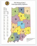
Regional mutual aid A-MA1-4 cover the same counties as ISP district 13 if that helps, Lake, Porter, Laporte, Newton, Jasper Starke and PulaskiProgramming Region A-MA into my scanners. Anyone have recommendations on range setting? It defaults to 165 miles. Not sure if I have to leave it there or how many sites would be on. Only concerned with a 4 county area.
counties.
File:SAFE-T Regional Mutual Aid Map.jpg - The RadioReference Wiki
File:ISP District Map.jpg - The RadioReference Wiki
afdscan
Member
I believe the Wiki page posted here for the SAFE-T Regional Mutual Aid Map is outdated. Just FYI.Regional mutual aid A-MA1-4 cover the same counties as ISP district 13 if that helps, Lake, Porter, Laporte, Newton, Jasper Starke and Pulaski
counties.

File:SAFE-T Regional Mutual Aid Map.jpg - The RadioReference Wiki
wiki.radioreference.com
File:ISP District Map.jpg - The RadioReference Wiki
Anyone can update the wiki anytime they want to. Feel free to post the newest data.I believe the Wiki page posted here for the SAFE-T Regional Mutual Aid Map is outdated. Just FYI.
- Status
- Not open for further replies.
Similar threads
- Replies
- 0
- Views
- 271
- Replies
- 20
- Views
- 1K