Transmitter Hunting way up north

Status
Not open for further replies.

N7YUO

Member
Joined
Mar 23, 2004
Messages
694
Location
Kearns, UT
I got out of class early today, so I went transmitter hunting up north of Snowville.
I was hoping to receive Dunn Peak, Raft River Mts.

I got way more than I bargained for.
State Route 30 goes from Snowville, UT to Elko, NV.
The area has very little population, and very little vehicle traffic.
I expected the scanner to search silently and only pick up local sites.
And I got (853.475 Cal Mtn), (851.9375 Howell), and (851.6625 Hansel), which I expected.
I locked them out.
*
Then I got Logan Peak, Mt Ogden came next, then Promontory. I kept locking them out of search.
I got a p25 so strong it was like being parked outside the transmitter site. 92085-00A LDS Church.
Next I got Nelson, then South Mtn.
There was so much voice and so many Control Channels that
it made searching a futile effort. I gave up and decided to head home.

I put the scanner on scan, and SLC PD was coming in loud and clear until I reached Snowville.
After that, all I got was occasional Box Elder radio traffic.
 

kirkco

Member
Premium Subscriber
Joined
Oct 21, 2018
Messages
81
Location
Erda, Utah
Now that type of road trip sounds like a lot of fun irregardless of the result. Got to be careful in remote country with lost of snow and cold around and few travelers. What unit do you use on your hunting trips?
 

gldavis

KE7MQF
Premium Subscriber
Joined
Oct 17, 2002
Messages
1,405
Location
Bountiful, UT
Witch direction did you go from Snowville? About where did you pick up the LDS system (site-??)?
Last time I took a trip up that-a-way, I forgot to take a radio with me (silly, huh?).
 

N7YUO

Member
Joined
Mar 23, 2004
Messages
694
Location
Kearns, UT
Which direction from Snowville?
Open: atlas.utah.gov not google maps.
and zoom in on Snowville.
On I-84 at exit 5 is UT Route 30, zoom in on the route until you can see mile markers. I picked up LDS P35 at mile 89 on Route 30.
 

N7YUO

Member
Joined
Mar 23, 2004
Messages
694
Location
Kearns, UT
Careful in remote country?
Well the road is paved and there were a few other cars. But none of my family had a clue where I was.
What if I had a breakdown?
I took the WS1040 and my newest Unitrunker v1.
When search found a data channel, I would have to enter that freq in the TUNE. Tune will dispay the SYSID System ID 7202 and SID Site ID 16 and sometimes the site name.
The Uni is on a small Acer Aspire powered thru a 12Volt-120 volt ac inverter.
I had difficulty getting it to work.
Uni would open on screen, but when I tried to activate a receiver, nothing would happen.
 

gldavis

KE7MQF
Premium Subscriber
Joined
Oct 17, 2002
Messages
1,405
Location
Bountiful, UT
When I'm out "Researching Electromagnetic Disturbances in the Earths Ether", I bring a Dell Latitude 2110, with a car charger, connected to a 14 Ah battery using an Anderson block to provide power to the system. If I'm gonna be out a while, I bring along a Goal Zero Solar Panel connected thru a Charge Controller, to keep the battery charged.
I have several of the Latitudes that I use with my portable AREDN nodes.
Back on subject,,,,, so head West from Snowville on SR30. Got it. looks like a field trip, next week.
 

N7YUO

Member
Joined
Mar 23, 2004
Messages
694
Location
Kearns, UT
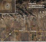
The new site that I was hunting for is Dunn Peak:
WQXW712
APPROX 10.3 KM SE OF STANDROD, UT BOX ELDER County
(DUNN PEAK, RAFT RIVER MTS)
41°54'16.3"N, 113°23'20.3"W
-113.38901, 41.90455
Hwy 30, mile 92 is approximately -113.389
raft 2.JPG
 

enosjones

Member
Premium Subscriber
Joined
Feb 22, 2006
Messages
1,897
Location
Price, Utah
When I find out that there’s a new site I program the scanner with that site, frequencies and if needed the custom band plan , especially for the rebanded UCA , then when I pick up the control channel I sit on the control channel for the site number, I program it as a system, but I also program it as a conventional frequency
 

enosjones

Member
Premium Subscriber
Joined
Feb 22, 2006
Messages
1,897
Location
Price, Utah
If I find out there’s a potential new site from FCC I program it into my scanner, if I’m in the area I want I let it scan , if it stops on the control channel in the conventional programming , then I go to the trunked programming to get site info, I don’t drive so I don’t usually haul my laptop with unitrunker loaded, cuz I’m usually with someone else, less bulky that way..
 

gldavis

KE7MQF
Premium Subscriber
Joined
Oct 17, 2002
Messages
1,405
Location
Bountiful, UT
I make specific Field Trips to see/hear if there are any signals out at/near that location. I don't check FCC records before (or after) going out. (Once I get my DF system operating, then I may be concerned with the location of the xmitter, but until then,) I'm just curious what is "hearable".
I will get to the location, set up my equipment, then normally I scan/search thru the UHF Fed band (380~420 MHz) and the 800~900 band. The radio will decode the control channel and Unitrunker will record the data. After a few hours, I'll go home and analyze what was recorded for anything new/different.
I drove out to Snowville yesterday on a recon trip. Using just a handheld, the only control channel I received was UCA Site 15. On two different freqs. I will be going out again (tues) with full gear and do a more comprehensive study of the Ether up there.
 

enosjones

Member
Premium Subscriber
Joined
Feb 22, 2006
Messages
1,897
Location
Price, Utah
Yeah site 15 is the snowville udot shed site, but it's also good to confirm the site numbers in case they change them or switch something from zone 1 7202 to zone 2 643E, I've caught errors before and had to contact people to fix them, (I.e noaa weather radio fcc license number error)
 

enosjones

Member
Premium Subscriber
Joined
Feb 22, 2006
Messages
1,897
Location
Price, Utah
It will give us good practice for when the system changes to p25, system and site info will no doubtly change, and we will need to go hunting anyway, good practice..
 

WB9YBM

Active Member
Joined
May 6, 2019
Messages
1,390
I got out of class early today, so I went transmitter hunting up north of Snowville.
I was hoping to receive Dunn Peak, Raft River Mts.

That far north, must be some super-secret snowman comm going on--I've always wondered what they think when just standing around all day. And what are they hiding behind that strange charcoal-like grin? :cautious:
 

N7YUO

Member
Joined
Mar 23, 2004
Messages
694
Location
Kearns, UT
That far north, must be some super-secret snowman comm going on--I've always wondered what they think when just standing around all day. And what are they hiding behind that strange charcoal-like grin? :cautious:
Curious, how does a member from Niles, IL know what "way up north" (in Utah) is like?
 

N7YUO

Member
Joined
Mar 23, 2004
Messages
694
Location
Kearns, UT
I went to Utah Test & Training Range today.
I searched from 850 to 860 on my WS1040.
I started getting a lot of voice and Motorola CC hits.
I entered the first CC hit into the Tune on my WS1040.
It was Nelson Peak, over a hundred miles and with several mountain ranges between.
When we drove east from the Oasis Compound, all reception stopped.
Conclusion: This is Tropospheric Propagation.
When I am in Box Elder County, (Snowville, Oasis, etc), I experience this propagation.
 
Status
Not open for further replies.
Top