I'm a newbee to scanning trunked systems and I've been having a rough time finding frequencies to enter for the trunked system in my area. Here is what I've got: A Whistler WS1040 scanner with ARC500 software. I know the trunk system is starcomm21 and I have the Norrdge, Harwood Heights and Schiller park talk groups but what gives me trouble is finding the frequencies for the trunk system. When I look up Norridge on
RadioReference.com it show the starcomm21, the talk group and it says that its patched to 471.2875 which is the old analogue frequency. I've searched high and low and I can't find the right frequencies. I found a list of 365 frequencies used by Starcomm21 in illinois but the software only has room for 32. Please someone help me get this set up properly.
Since you indicate that you already have located the talkgroup IDs used in your area. it sounds like you are having trouble determining which sites to use. Remember that you choosing the sites that cover your area, not trying to separately program some of the frequencies.
Pull up the Starcom21 database page
https://www.radioreference.com/apps/db/?sid=2324
Now, look at the list of sites:

(Only showing the first few for clarity)
From this point, there are two ways to proceed. Use either one, or look at both.
If you click on the column heading County, just above the list of sites, it will re-sort them by the county name where each site is located. Some counties have more than one site. What you are looking for is the sites that are located in your county, and depending on what you want to hear, maybe one or more of the adjacent counties. In general, a given site will carry the talkgroups for agencies in that area, whether at the county level, or cities, towns, or services (such as EMS) in the area.
Look at this section of the sites. I have clicked on the County header (highlighted) and the page has sorted the sites by their county locations:

Some of the sites are named after the city, or county they're in, others may be named after a local landmark or other things. Rather than trying to guess what the site name means, use the county sort to find the names of the sites near you, so that you can select the correct ones when importing into Win500.
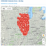
You can also look at the locations on a map. Click on the title RR Locations; see the highlighted screenshot below:

When you click that, it will take you to a map showing markers where each site is. Remember that the marker is in the location based on what it's trying to cover. The actual site maybe vary some, and also some sites are simulcast, so there is more than one actual tower tied to that site listing. Here's what you get:

Use the large plus and minus signs in the lower right corner to zoom into your area. Click on the map after you have zoomed in some, then hold down the mouse key so that you can drag the map as needed to get to your area.
On the map below, I have zoomed into the Chicago metro area. Click on one of the balloon markers to find the name of the site it represents. I noticed that in some counties, there are two or more sites, where one of them is labeled as a "site on wheels". That's actually a portable site, that can be deployed to bolster coverage in an area in case of a large disaster response, or to temporarily replace a site that have been damaged or destroyed by weather or another incident.

See if the above helps you determine which sites you need for your area.