You are using an out of date browser. It may not display this or other websites correctly.
You should upgrade or use an alternative browser.
You should upgrade or use an alternative browser.
Vor's, ILS, NDB
- Thread starter scubasky
- Start date
- Status
- Not open for further replies.
umm .. yes.
Newark777
Member
Yes, although nothing too interesting ever comes across. Unless you find morse code interesting. 
I am thinking of turning it into a geocaching hunt type thing. I know morse code although the 3 or 4 letters they xmit are not hard. It would be cool to use some primitive Direction Finding rig to hunt down the signal and see what the shacks look like, or google their ass and just drive over there lol
Lat/Long available at http://www.airnav.com/navaids/ 
Newark777
Member
kicktd said:Lat/Long available at http://www.airnav.com/navaids/
I've plugged all the nearby ones into Google Earth, so that when a pilot says, "Direct XXX," I know exactly where he's going.
How often do they ID? I put a couple ILS/VOR freqs in for the local airport just for kicks one time and spent 15 or 20 minutes listening to open carrier with nothing else.
Newark777
Member
Jay said:How often do they ID? I put a couple ILS/VOR freqs in for the local airport just for kicks one time and spent 15 or 20 minutes listening to open carrier with nothing else.
When I'm out in PA I'm within range of the Allentown VOR, and it seems to be a constant morse code signal to me.
Yokoshibu
Member
- Joined
- Feb 8, 2005
- Messages
- 362
they run an am / cw signal for the most part so if you dont hear anything you probably are not going to hear it ID... silence with code every couple seconds... of course its more than an am /cw signal and if you got some equipment that you know how to use you can get the radial you are on from the vor
scubasky said:Assuming you could get the signal could you pick up any of these nav aids? I know they transmit their own Morse identifier. They are in the range of a scanner too I think it is 109-119 ish
Just for clarification, the ILS's will operate between 108.0 and 111.95 MHz, the VOR's between 112.0-117.95. The NDB's are MF stations in the 190-535 kHz range, which you can receive with a shortwave radio. However, most of these are being decommissioned, and the VOR's are supposedly about 10 years behind the NDB's for decommissioning.
Happy hunting!
ampulman
Member
captaincraig44 said:Just for clarification, the ILS's will operate between 108.0 and 111.95 MHz, the VOR's between 112.0-117.95. The NDB's are MF stations in the 190-535 kHz range, which you can receive with a shortwave radio. However, most of these are being decommissioned, and the VOR's are supposedly about 10 years behind the NDB's for decommissioning.
Happy hunting!
Interesting. What are they going to use to replace the VORs?
I know many private aircraft are using GPS for backup or position location. Don't know about commercial aircraft. The only flying I have done is as a passenger or at my computer (flight simulator).
AM
Newark777
Member
ampulman said:Interesting. What are they going to use to replace the VORs?
I know many private aircraft are using GPS for backup or position location. Don't know about commercial aircraft. The only flying I have done is as a passenger or at my computer (flight simulator).
AM
I took this from one of the links above:
Like many other forms of aircraft radio navigation currently used, it is likely that some form of space-based navigational system such as Global Positioning System (GPS) will replace VOR systems. VOR is specifically in jeopardy because of the need for numerous stations to cover a large area. The satellite-based GPS is capable of reliably locating an aircraft's position within about 100 feet horizontally. Augmented by "Wide Area Augmentation System" (WAAS) currently being deployed in the U.S., the error is reduced to a cube about 10 feet on a side. This allows precision instrument approaches (with laterial and vertical guidance) with landing weather minima nearly as low as the Category I Instrument Landing System -- but no ground based equipment except for a relatively few units that determine the WAAS correction signals relayed through satellites to user aircraft. Further refinements include "Local Area Augmentation System" (LAAS) which will probably allow Category III approaches (practically speaking, landings in "zero-zero" weather -- again, with minimal requirement for ground stations. LAAS is planned to use the same VHF frequency band for its correction message. This might require some existing VOR facilities to be shut down or shifted to different frequencies to avoid interference issues
http://en.wikipedia.org/wiki/VHF_omnidirectional_range
captaincraig44 said:Just for clarification, the ILS's will operate between 108.0 and 111.95 MHz, the VOR's between 112.0-117.95.
There are lots of VORs that operate below 112.0
Mike
Depending on what kind of site you are talking about, weather it is a VOR/DME (or VORTAC), the ID is sent out 3 times by the VOR, and once by the DME or TACAN . This means that at around every 37.5 seconds, the DME/TACAN idents, and the rest of time, the VOR idents.
If the site is a stand alone VOR, it will ident at approximately every 7 seconds. Up here in Canada, the IDent is a 3 letter morse code.
In reference to the Frequency Range of VOR's and ILS's , they operate in the same band (108.1MHz to 117.95MHz for Localiser Function is VHF, Glideslope is UHF). The VOR's are paired to ILS and DME frequencies depending on what channel they use, and they cannot be mixed. In fact, when the pilot selects an ILS frequency, the DME frequency is automatically selected, and he doesn't even see the frequency (DME's are UHF and operate around 980Mhz-1200Mhz and are digital systems)
And the ID is about the only thing you would hear on a VOR signal. The NAVTones are 30Hz (AM and FM), and 9960Hz, so your AM Rx will pick it up, but you wont hear anything.
The way a VOR functions is that it takes the difference in phase from a reference signal (30Hz AM) from a variable signal (30Hz FM). From this phase difference, the VOR Rx calculates the degree, and basically that's it.
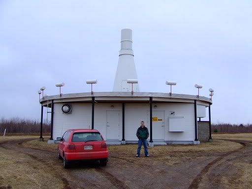
The Tacan does the same thing as a VOR, but in UHF Frequencies. The VOR uses electronic antenna commutation to generate the Limichon Pattern, while the Tacan uses a mechanical rotating antenna to achieve the same pattern.
VORTAC

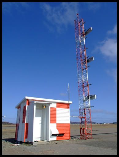
Glideslope

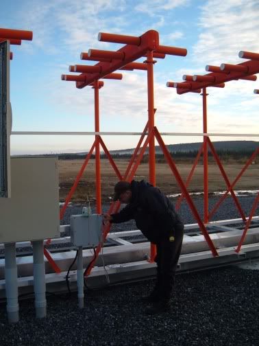
Localiser

I hope I cleared some stuff up.
Cheers.
If the site is a stand alone VOR, it will ident at approximately every 7 seconds. Up here in Canada, the IDent is a 3 letter morse code.
In reference to the Frequency Range of VOR's and ILS's , they operate in the same band (108.1MHz to 117.95MHz for Localiser Function is VHF, Glideslope is UHF). The VOR's are paired to ILS and DME frequencies depending on what channel they use, and they cannot be mixed. In fact, when the pilot selects an ILS frequency, the DME frequency is automatically selected, and he doesn't even see the frequency (DME's are UHF and operate around 980Mhz-1200Mhz and are digital systems)
And the ID is about the only thing you would hear on a VOR signal. The NAVTones are 30Hz (AM and FM), and 9960Hz, so your AM Rx will pick it up, but you wont hear anything.
The way a VOR functions is that it takes the difference in phase from a reference signal (30Hz AM) from a variable signal (30Hz FM). From this phase difference, the VOR Rx calculates the degree, and basically that's it.
The Tacan does the same thing as a VOR, but in UHF Frequencies. The VOR uses electronic antenna commutation to generate the Limichon Pattern, while the Tacan uses a mechanical rotating antenna to achieve the same pattern.
VORTAC

Glideslope

Localiser

I hope I cleared some stuff up.
Cheers.
n211cr
Member
I know some VOR's transmit the weather(AWOS / ATIS) along with the CW or morse code, and as for hunting them its going to be hard unless you are fairly close to them already. I know I have only picked them up from the ground when within a few miles.
- Status
- Not open for further replies.
Similar threads
- Replies
- 8
- Views
- 1K
- Replies
- 4
- Views
- 415
- Replies
- 2
- Views
- 1K

