Water Station Transmitters - What Are They?

Status
Not open for further replies.

emsflyer84

Member
Premium Subscriber
Joined
Mar 22, 2012
Messages
386
Location
Central NH
Hey guys, just curious on this more then anything. I was driving around the other day and saw a small wooden hut next to a creek on the side of the road with a state sign on it that said something like "Water Station ________". There was what looked like a directional Yagi antenna attached to the roof of the hut. The hut wasn't even big enough for a person to go inside, more like a wooden box.

I'm in Central NH. Just curious what this might be, and what kind of information they might be transmitting, and to who? Thanks guys! I'll try to grab a picture when I go by.
 

emsflyer84

Member
Premium Subscriber
Joined
Mar 22, 2012
Messages
386
Location
Central NH
Thanks. This one was pointed up like at a 45 degree angle, facing south east. It might be angled up because it sits very low down off the side of the road.
 

wbloss

Human
Database Admin
Joined
Dec 19, 2002
Messages
1,062
Location
Joplin MO
Thanks. This one was pointed up like at a 45 degree angle, facing south east. It might be angled up because it sits very low down off the side of the road.
It is hitting a satellite with flow rate and depth info. It transmits "blind" every few minutes, seems like in the ~400MHz range (406?)
Need to look that up!
FInd it here: USGS Surface-Water Data for the Nation
 

nd5y

Member
Joined
Dec 19, 2002
Messages
11,286
Location
Wichita Falls, TX
They are somewhere in the 400-406 MHz band and the downlink from the sat is a different band. 2 or 3 GHz if I remember. I saw an article about that a while back. Somebody with as SDR was able to decode the satellite downlink passband.
 

iMONITOR

Silent Key
Premium Subscriber
Joined
Sep 20, 2006
Messages
11,156
Location
S.E. Michigan
It is hitting a satellite with flow rate and depth info. It transmits "blind" every few minutes, seems like in the ~400MHz range (406?)
Need to look that up!
FInd it here: USGS Surface-Water Data for the Nation

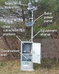
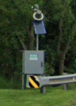
I wondered what those were. I see several of those around where I live. Always mounted near bridges on small rivers/streams. They look similar to this:
1603297379275.png
 

ecps92

Member
Joined
Jul 8, 2002
Messages
14,414
Location
Taxachusetts
Where was this, might be able to tell more from google earth

As others said, SCADA or a GOES, central NH, likely river reporting for the USACoE

Hey guys, just curious on this more then anything. I was driving around the other day and saw a small wooden hut next to a creek on the side of the road with a state sign on it that said something like "Water Station ________". There was what looked like a directional Yagi antenna attached to the roof of the hut. The hut wasn't even big enough for a person to go inside, more like a wooden box.

I'm in Central NH. Just curious what this might be, and what kind of information they might be transmitting, and to who? Thanks guys! I'll try to grab a picture when I go by.
 

mmckenna

I ♥ Ø
Joined
Jul 27, 2005
Messages
23,869
Location
Roaming the Intermountain West
Yeah, crossed UHF yagi's pointed up at the sky would be GOES.

If it's not pointed up at the sky, then it's something terrestrial. Maxon makes small data radios often used for this purpose. The radio is about the size of a couple decks of cards. Run up to 5 watts, have an DB-9 connector on the side. You can stuff those in a small box with a battery/solar panel and stream slow speed data out.
 

iMONITOR

Silent Key
Premium Subscriber
Joined
Sep 20, 2006
Messages
11,156
Location
S.E. Michigan
Status
Not open for further replies.
Top