Who owns this orange box?

Status
Not open for further replies.

GrayJeep

Member
Premium Subscriber
Joined
Jan 6, 2007
Messages
967
Location
N. Colo.
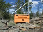
Hiking in Roosevelt National Forest I came across this box. No ownership markings of any kind.

It appears to be a portable repeater. There are two antennas up on the mast, that's a solar panel on the silver frame
and the coax connections on the box (other side) are labelled "north portable" for the left one and "scene of action" for the right one.

NFS fire scene portable repeater? (it's about 3 miles up a jeep trail behind seasonally locked gates. I walked to it.)

repeater_3429_S.jpg
 
Last edited:

ScannerSK

Member
Joined
Mar 6, 2005
Messages
1,349
Location
Weld County, Colorado
If you pinpointed the GPS location, you could enter that in an FCC query to potentially see who it belongs to. You can also enter in a GPS query with a search box radius around the surrounding area.
 

kruser

Active Member
Premium Subscriber
Joined
Nov 25, 2007
Messages
4,990
Location
West St Louis County, MO
I guess if the system is on the air, you could always run a close call type scan and see if you can find any frequencies it is using while you are standing near the thing. Even temp setups should be licensed and if so, an FCC search may reveal the owner.
 

kruser

Active Member
Premium Subscriber
Joined
Nov 25, 2007
Messages
4,990
Location
West St Louis County, MO
Not if it's Federal. Federal users are covered by the NTIA, and they don't have a publicly searchable database.
However, if you go here and look under the Roosevelt National Forest, you'll find the Scene Of Action repeater listed. Try 169.950

Very true for NTIA allocated users. I guess your best bet would be hoping it was submitted here like you mentioned.

I was thinking more like sites used for temp repeaters like those commonly known as SOWS in todays lingo for LMR. Of course a lot of SOWS in use out there seem to be 700 MHz units using state licenses that usually don't show up at the FCC site either.
A close call scan is still worth running for a while though and if you are lucky, it will catch something that has been submitted here.

I know the Missouri Wing of the CAP was or did install a repeater on a tower at Taum Sauk mountain which is the highest point in Missouri.
They seem to be secretive about their frequencies these days so a visit to the site may be needed to try and catch it but with all the other transmitters at that location, finding it could be near impossible. I'd assume it's probably a P25 repeater unless the news article I read about it was really old. They do mention how they can also communicate on the statewide Moswin system here though so it had to be fairly recent news. I was researching the MO Wing of the CAP after hearing some comms on a couple unknown talkgroups here on Moswin.
They used terms like Eagle 50 to Eagle 51 for user names and a term of Region "Five Charlie" "5C" for their area.
I don't ever recall hearing user names of Eagle back in the days of the Analog CAP repeater here on 148.150 MHz. Possibly Eagle users are on the ground mobile identifiers while the aircraft use other names. I think "bluebird" may have been a common name back in the analog days but it's been a while since I monitored the CAP here.
 

ecps92

Member
Joined
Jul 8, 2002
Messages
14,414
Location
Taxachusetts
US Forest Service.
Portable = Temp generally used for SOA when outside of normal repeater Ops

Based on your observations
Likely on "North Zone"
169.9750 R / 164.1000

Hiking in Roosevelt National Forest I came across this box. No ownership markings of any kind.

It appears to be a portable repeater. There are two antennas up on the mast, that's a solar panel on the silver frame
and the coax connections on the box (other side) are labelled "north portable" for the left one and "scene of action" for the right one.

NFS fire scene portable repeater? (it's about 3 miles up a jeep trail behind seasonally locked gates. I walked to it.)
 

ecps92

Member
Joined
Jul 8, 2002
Messages
14,414
Location
Taxachusetts
Plenty of threads and a very good wiki for CAP [nothing secret if it transmits]
https://wiki.radioreference.com/index.php/Civil_Air_Patrol

If you need more, plenty of prior threads or start on for CAP

Back to the USFS at hand. :)

Very true for NTIA allocated users. I guess your best bet would be hoping it was submitted here like you mentioned.

I was thinking more like sites used for temp repeaters like those commonly known as SOWS in todays lingo for LMR. Of course a lot of SOWS in use out there seem to be 700 MHz units using state licenses that usually don't show up at the FCC site either.
A close call scan is still worth running for a while though and if you are lucky, it will catch something that has been submitted here.

I know the Missouri Wing of the CAP was or did install a repeater on a tower at Taum Sauk mountain which is the highest point in Missouri.
They seem to be secretive about their frequencies these days so a visit to the site may be needed to try and catch it but with all the other transmitters at that location, finding it could be near impossible. I'd assume it's probably a P25 repeater unless the news article I read about it was really old. They do mention how they can also communicate on the statewide Moswin system here though so it had to be fairly recent news. I was researching the MO Wing of the CAP after hearing some comms on a couple unknown talkgroups here on Moswin.
They used terms like Eagle 50 to Eagle 51 for user names and a term of Region "Five Charlie" "5C" for their area.
I don't ever recall hearing user names of Eagle back in the days of the Analog CAP repeater here on 148.150 MHz. Possibly Eagle users are on the ground mobile identifiers while the aircraft use other names. I think "bluebird" may have been a common name back in the analog days but it's been a while since I monitored the CAP here.
 

ecps92

Member
Joined
Jul 8, 2002
Messages
14,414
Location
Taxachusetts

GrayJeep

Member
Premium Subscriber
Joined
Jan 6, 2007
Messages
967
Location
N. Colo.
Thanks for the thoughts guys.

You all seem to agree that it's an NFS box.

Since it appears temporary an antenna search yielded nothing inside of 30 km - as expected.

Another possible past use is that to the west of that site there had been a 3 year project to clearcut either side of the Crown Point road for many miles. I think it was a beetle kill mitigation project as the cut wood was burned in big piles.

Perhaps this was setup to facilitate comms from that area.

Since no work is currently occurring the repeater would likely be dormant and close-call wouldn't find anything. I had a small ham HT tuned to 169.975 turned on for a few moments when I visited the spot again yesterday. No indication of transmission (no desensing of my radio).

I've programmed my scanners with all the NFS freqs for Roosevelt and so will listen when I'm up in that area again.

Basic Roosevelt NFS frequency is much quieter nowadays than it was 20 years ago. It's not obvious to me why that is though the frequency has changed (at least) and time has passed so everything changes with that much time passing.

I think we have a pretty good idea of what it is. It still seems rather odd that it's unlabelled. You'd at least expect a threat of prosecution for messing with govt property.....
 

ecps92

Member
Joined
Jul 8, 2002
Messages
14,414
Location
Taxachusetts
Even if it was not a TEMP use, it would not be found in an FCC search as federal agencies fall under the NTIA
and that DB info has not been avail since around the POTUS-40 days

Thanks for the thoughts guys.

You all seem to agree that it's an NFS box.

Since it appears temporary an antenna search yielded nothing inside of 30 km - as expected.

Another possible past use is that to the west of that site there had been a 3 year project to clearcut either side of the Crown Point road for many miles. I think it was a beetle kill mitigation project as the cut wood was burned in big piles.

Perhaps this was setup to facilitate comms from that area.

S
 

n0nhj

In way too deep...
Feed Provider
Joined
Feb 8, 2004
Messages
351
Location
Lakewood, WA
Is it near the park? Don't rule out Rocky Mt Nat'l Park. Not uncommon for Park repeaters to be in the forest to gain coverage, and vice versa.
Pic of the antennas might be helpful, are both VHF?
 

GrayJeep

Member
Premium Subscriber
Joined
Jan 6, 2007
Messages
967
Location
N. Colo.
Antennas seem to be VHF length though they are cylindrical green rather than obviously metal.
Site overlooks Poudre Canyon and might have coverage to the west along Crown Point Rd.
My theory is that it has to do with NFS and the beetle mitigation along the Crown Point Rd.
If you look on Google Earth at Crown Point road you can see the wide deforested shoulders along the road.
It used to be a nice shady drive but not any more.
 

crazy88

Member
Premium Subscriber
Joined
Jun 22, 2014
Messages
75
That Crown Point Rd project had several contracted helicopters operating, I wonder if this was used to somehow aid comms between the helicopters and ground crews.

I'm under the impression that the project is finished and that Crown Point Rd should be open this summer.
 

GrayJeep

Member
Premium Subscriber
Joined
Jan 6, 2007
Messages
967
Location
N. Colo.
I'm sure the Crown Point road project is done as there are no signs of road closure now.

I was up there on Wed scouting out the area with a buddy who is going to hunt up there in Oct.
 
Status
Not open for further replies.
Top