ADS_B recieving

Gordz

Member
Joined
Mar 17, 2025
Messages
5
G'day Brains trust.
I bought a flightaware ADS-B dongle. Their software apparently has to run via PI and thats too hard.
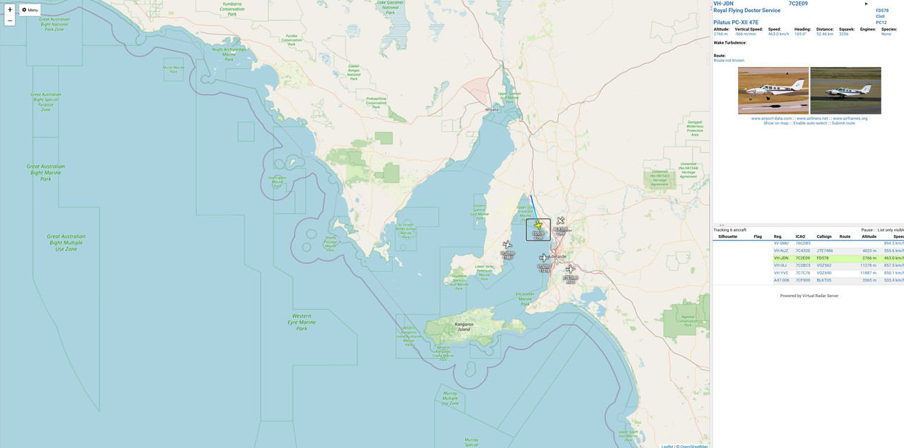
Im looking to get a program to run locally on my pc that shows my data on a map.
So i can have that running on the second monitor and see whats coming and going.
SDR# and similar allow you to upload to their software for the world to see.
Im not wanting to do that. I just want it for me here.
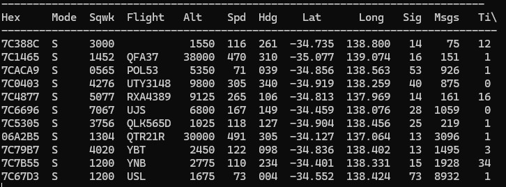
Currently i have a screen that shows the data, but not a map of such

Ive tried planeplotter. The graphics on that looked like a commodore 64.
Basically looking for a program like flightaware, but only on my local pc.
Appreciate any help you can give me.
 

Gordz

Member
Joined
Mar 17, 2025
Messages
5
Never mind. I found Virtual radar. If anyone is interested its quite good free software.

Its just on your pc. view via browser, but locally, not via web.
 

jeepsandradios

Member
Feed Provider
Joined
Jul 29, 2012
Messages
2,364
Location
East of the Mississippi
I used dump 1090, paired with Virtual Radar and Plane Finder Client. Worked well but I hated 3 sperate apps. Ran like that for over a year, but finally switched to ADSB Feeder. While it goes on a pi, you can order parts on amazon, follow directions and be loaded in monitoring in 30 minutes. Pretty simple.
 

Gordz

Member
Joined
Mar 17, 2025
Messages
5
I used dump 1090, paired with Virtual Radar and Plane Finder Client. Worked well but I hated 3 sperate apps. Ran like that for over a year, but finally switched to ADSB Feeder. While it goes on a pi, you can order parts on amazon, follow directions and be loaded in monitoring in 30 minutes. Pretty simple.
Waiting on admins to clear my last post. im new so they are doing approvals manually.
Basically i did the same. Virtual Radar is good. 200 km of coverage in all directions. You should see a post prior to this one onecer mods let it through. Full screen view of what i ended up with.
Im still not sure on the pi. Alot of linux work. Plus i need it on a pc screen. 7 inch Pi screen wont do much for me lol way too small. Through the pi its sending out as well. I want to keep it local on my system. Dont like the idea of advertising an open port for no reason. Cheers for answering. Appreciate your time
 

morfis

Member
Joined
Jan 24, 2004
Messages
1,700
Using a pi (or similar) is simple enough. No real linux learning necessary.
Plenty of ready made linux images available so it's almost 'plug and play'.
Connect your pi to your main pc by whatever network method you want. Use VRS (or other mapping display) on your main pc to view your data.
When you have done that you can chose whether to share data outside your own local network (and there are quite a few reasons you might want to do so).
Would the thousands of people already sharing their data this way still be doing so if there was a real perceived threat to their systems?

I have been feeding data to the PlanePlotter network since it first began and also operate about a dozen pi's for aviation monitoring with much data shared to multiple sites 'because I can' (I have no real interest in 99% of the data or tracking sites). Never had a single issue related to unwanted network activity.
 

jeepsandradios

Member
Feed Provider
Joined
Jul 29, 2012
Messages
2,364
Location
East of the Mississippi
ADSB_Feeder is all that runs on the Pi wiuth the SDR. I connect with my laptop to the "server" address. I actually connect via phone when im on the deck to see what is overhead.
 

Gordz

Member
Joined
Mar 17, 2025
Messages
5
Using a pi (or similar) is simple enough. No real linux learning necessary.
Plenty of ready made linux images available so it's almost 'plug and play'.
Connect your pi to your main pc by whatever network method you want. Use VRS (or other mapping display) on your main pc to view your data.
When you have done that you can chose whether to share data outside your own local network (and there are quite a few reasons you might want to do so).
Would the thousands of people already sharing their data this way still be doing so if there was a real perceived threat to their systems?

I have been feeding data to the PlanePlotter network since it first began and also operate about a dozen pi's for aviation monitoring with much data shared to multiple sites 'because I can' (I have no real interest in 99% of the data or tracking sites). Never had a single issue related to unwanted network activity.
You say you use a dozen pi's to monitor aviation. Apart from ads-b what can you monitor ? I was going to try ads-c but satellite sounds a bit past my skill set. What other cool stuff do you monitor with the other 11?
BTW mines running locally now, with a 250km/155 miles range, which gets it done.
 

Gordz

Member
Joined
Mar 17, 2025
Messages
5
Using a pi (or similar) is simple enough. No real linux learning necessary.
Plenty of ready made linux images available so it's almost 'plug and play'.
Connect your pi to your main pc by whatever network method you want. Use VRS (or other mapping display) on your main pc to view your data.
When you have done that you can chose whether to share data outside your own local network (and there are quite a few reasons you might want to do so).
Would the thousands of people already sharing their data this way still be doing so if there was a real perceived threat to their systems?

I have been feeding data to the PlanePlotter network since it first began and also operate about a dozen pi's for aviation monitoring with much data shared to multiple sites 'because I can' (I have no real interest in 99% of the data or tracking sites). Never had a single issue related to unwanted network activity.
when you say a dozen pi's is that for different things in aviation or just lots of ads-b and tower channels? Im just trying to work out what else i can do
 

737mech

Member
Premium Subscriber
Joined
Aug 14, 2006
Messages
2,533
Location
Clark County, NV.
For local ADSB tracking I use the STRATUX img on my Pi 3B with 2 sdr’s (978/1090) plugged in to the the usb ports. The Stratux then sends data to my ipad and I watch the map from the app. It also does logging and much more. You can add AHRS chip to the pi and get an attitude indicator to work. I also add a GPS to place my position on the map.
 

vagrant

ker-muhj-uhn
Premium Subscriber
Joined
Nov 19, 2005
Messages
3,521
Location
California
For local ADSB tracking I use the STRATUX img on my Pi 3B with 2 sdr’s (978/1090) plugged in to the the usb ports. The Stratux then sends data to my ipad and I watch the map from the app. It also does logging and much more. You can add AHRS chip to the pi and get an attitude indicator to work. I also add a GPS to place my position on the map.
Can you download a map of one’s locale and use this without an Internet connection? After you initially set it up of course. I’d like a compact solution sans Internet access. I have most of the parts.
 

737mech

Member
Premium Subscriber
Joined
Aug 14, 2006
Messages
2,533
Location
Clark County, NV.
Can you download a map of one’s locale and use this without an Internet connection? After you initially set it up of course. I’d like a compact solution sans Internet access. I have most of the parts.
The stratux app menu option has a low grade map without internet needed. Showing your location would require the gps input.
 

vagrant

ker-muhj-uhn
Premium Subscriber
Joined
Nov 19, 2005
Messages
3,521
Location
California
It appears that I did have the parts needed for a compact solution. This works fine with an Android phone along with an OTG cable. The 1090 MHz antenna came with an ADSBExchange SDR dongle which is being used elsewhere on a 24/7 feed. I like this OTG cable as it allows me to alternatively power the SDR with a small USB battery versus pulling power from the phone. I prefer it power the phone instead. That OTG cable is 6 years old, so there's probably what I want out there now...if my micro USB phone supports charging while using the OTG. :unsure:

The software running is Avare. It's the free version, but I think I'm going to upgrade to the Pro if I can pre-load sectional charts when I have zero Internet. If there's other Android software please advise. The range ring in the middle map photo is probably 50 nm which is fine from indoors near a window. I would typically be using this outdoors. The data on the right photo can actually scroll left to show more info. This software can also be custom set to alert you when an aircraft is within "x" miles away.

IMG_2286.jpg IMG_2288.JPG IMG_2290.JPG
 
Top