BCD325P2/BCD996P2: BCD325P2 with BC-SGPS

brcoz

Member
Premium Subscriber
Joined
Feb 23, 2007
Messages
123
Location
Florence, AZ
I got the GPS a few days ago. I do see "GPS Connected" message and in the upper right corner "GPS". So it is connected.
I have a question with systems programming. (I use Pro scan)
Is it better to have no Quick Keys setup and have them all enabled? Or none?
I am not sure if when it is scanning do all quick key number blink. I had two CONV quick keys enabled and they would flash. They are in another state and too far to stop on. Just want to make sure if I am doing it correct. I have scanned the forums and I was not able to find the answer.

Thanks in advance.
 

wtp

Member
Joined
Apr 3, 2008
Messages
6,607
Location
Port Charlotte FL
from a manual
You can connect the scanner to a compatible GPS device and set the scanner to automatically lock and unlock trunked sites and channel groups based on the location information and range settings you program for those sites/groups.
so you have to have the systems you want to monitor in the radio and set up for GPS.
 

brcoz

Member
Premium Subscriber
Joined
Feb 23, 2007
Messages
123
Location
Florence, AZ
I did read the manual and did a search of the forums. I was not able to find an answer because a group that was out of range would show the system name as well as system in range. I guess that is normal? I thought it would not display if out of range.
So no quick keys assigned and the channel groups should not display that are out of range?

I'll do some testing. Thanks for your info.
 

wtp

Member
Joined
Apr 3, 2008
Messages
6,607
Location
Port Charlotte FL
i am not the best for this as i don't use GPS at all.
but from what i have seen and read, you need all the systems that you want to listen to already in the radio, you have to set location and range of all of them. the 325 and 996 do not have any systems in them when you get them.
so if you want to set up quick keys then do that.
we don't know really what you are trying to do.
 

brcoz

Member
Premium Subscriber
Joined
Feb 23, 2007
Messages
123
Location
Florence, AZ
I am trying to learn how to use the GPS on my scanner so I do not have to keep turning on/off systems as I travel like I have done for years.
I mentioned that I have systems loaded in the scanner and did a test to see if having no quick keys and all systems enabled. I had one that is way out of range. I see the name flash as the scanner is scanning. I would think if the GPS turns on/off that system would not show on the display like the systems in range.
I have not used a GPS for a scanner. I have in the car, hiking and to get my latitude and longitude to input to a telescope mount.

Thanks for your help.
 

brcoz

Member
Premium Subscriber
Joined
Feb 23, 2007
Messages
123
Location
Florence, AZ
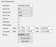
Pro-scan does have the range input.
 

Attachments

  • scanner.jpg
    scanner.jpg
    23.3 KB · Views: 11

brcoz

Member
Premium Subscriber
Joined
Feb 23, 2007
Messages
123
Location
Florence, AZ
I am going to do another test to make sure. I took a drive that some systems would be in range and then not. It seemed that the out of range system names did not display. It is hard to drive and watch the small screen at the same time. I may make a change to the miles in the range also to see if that helps.

All of the info on the gps with the scanner is only the SDS100/200. They all mention setting the mile range smaller like 10 to 0.

I'll let you know what I find.

Bruce
 

wtp

Member
Joined
Apr 3, 2008
Messages
6,607
Location
Port Charlotte FL
0 (zero) would just be that you are 'in the circle' or guaranteed range of the system.
and that is not bad.
and there is a small difference on hold time and delay time.
delay is just like the delay of years ago, the radio waits for a reply after a squelch break.
hold is how long the radio stays on and scans the system. kind of like spinning wheels in place.
so,
mile range 0
delay 2
hold 5 and that way you can see the system as it goes by. if set to 0 you will not see a small conventional system.
even 5 frequencies will barely show.
for trunked systems a setting of 0 to 2 are all the same, 2
there is a 'housekeeping' of 2 seconds on trunked system for the radio to see what is going on.
 
Last edited:

brcoz

Member
Premium Subscriber
Joined
Feb 23, 2007
Messages
123
Location
Florence, AZ
I changed the mile range on systems near me. I changed the system that is out of range from 50 to 40 to make sure it was out of range.
I took a drive and the scanner picked up very little traffic. It did seem that the range change did affect the systems that I could pickup from my house and with the change I had to get closer to that city and then no traffic from the city I live in. I would still see the system name on the screen that in no way I could pick up. When I got home I put the local systems back to the range they were before. I took another short drive and I picked up more traffic. Also the system that was out of range I still see the name on the screen.

I will check the "hold" setting to see what it is set to. I did not change that one and will change if needed.

Thanks for the comments.
 

brcoz

Member
Premium Subscriber
Joined
Feb 23, 2007
Messages
123
Location
Florence, AZ
I did a test run changing the hold time to 5 sec. I am still seeing the system that is out of range. I thought by using the GPS it would not display at all. I am going to change the range and keep the hold at 5 or maybe 7 for just that system.
I have thought about one of the scanners that have the whole database on it because all of the information regarding GPS is for them. I have searched the Internet.
However, to spend $500+ just to use on trips is not for me. The may reason is everything is going to the big E and with less to listen to. Even where I live the LE is going dark. Glad I was able to have scanners since the old days with them there crystals.
 
  • Like
Reactions: wtp

brcoz

Member
Premium Subscriber
Joined
Feb 23, 2007
Messages
123
Location
Florence, AZ
Well I tried another test and the systems that are in another state are still showing on the screen with the local systems. I do see GPS on the screen so the scanner sees it. When I changed my local systems mile range to about 5 miles I did not hear very much traffic. The out state system was still showing on the display. I changed the local mile range back to what it was.
I guess I am the only one with the BCD325p2 trying to use GPS.
 

hiegtx

Mentor
Premium Subscriber
Joined
May 8, 2004
Messages
11,458
Location
Dallas, TX
Well I tried another test and the systems that are in another state are still showing on the screen with the local systems. I do see GPS on the screen so the scanner sees it. When I changed my local systems mile range to about 5 miles I did not hear very much traffic. The out state system was still showing on the display. I changed the local mile range back to what it was.
I guess I am the only one with the BCD325p2 trying to use GPS.
The 325P2, unlike the BCDx36Hzp & SDS series database scanners, does not have the full database available in the scanner. So you must have those 'out of state' systems included in your programming file for them to show up as being scanned.

The range settings, when used with location control & a GPS, are based on whether the location & range for a given system puts that system within the range settings on your scanner. As used by the scanner, the range for whether or not a system is active when using location (as with a GPS) is based on whether the range circle for the system, overlaps the range circle on your scanner. If a system is listed with a 20 mile range, and you have a range set (in your scanner) of 10 miles, then that system would be scanned if you are within 30 miles of it (the system's range of 20 miles plus the range setting used in your scanner, 10 miles).

Ranges used with a GPS are the distance to the systems center, as defined in the database. It does not cut off at the state line (or any other boundary such as a county). Statewide systems can often have a range setting in the hundreds of miles, so that the system's location & range apply to any location within the state. Since states are not circular in size, a range sufficient to cover all points in the state, from a given site for the system, will overlap the state line in some areas, If a system was at the center of a state, and that state was roughly rectangular, 400 mile north to south, and 300 west to east, with the site location set at the center of the state, it would require a 200+ mile range setting to cover areas out to the northern or southern borders. But that 200 range would overlap up to 100 miles into a neighboring state, since the border is only 100 miles out.

This page was directed at users of the HP-1/-2 series scanners, and later database scanners. But the basic concept of how the scanner uses location and range apply to the DMA scanners as well.
How it Works: Location, Location, Location

Look at your programming file, and at the 'out of state' system you are referring to. I suspect you'll find a long range setting. For the database scanners, such as the x36HP, SDS, and HP-1/-2, you can edit the range in the main database, or set a given system to Avoid (locked out). You also have the option of defining the systems range footprint as a rectangle, instead of only a circle as used by your 325P2. In your 325P2, you can edit the range of a system in your programming file. For location control to be effective, you need to have that system set to use location.
1711863105861.png
If location on a given system is not enabled, the system would be scanned unless locked out manually or via a quick key. Location & ranges are set at the Group level on Conventional systems. For trunked systems, location & range settings are also in effect for sites.

For your "out of state" intruder, review your programming file. Look at that specific system and modify it's location & range settings so that it does not overlap into the area covered by your local systems.

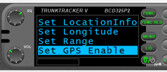
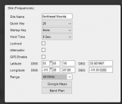
For the screenshot shown as a screenshot in post 6 , you do not have the GPS (location) enabled, so that would always be scanned. That 45 mile range shown would be ignored, unless you do enable the GPS.

1711863735299.png
 

brcoz

Member
Premium Subscriber
Joined
Feb 23, 2007
Messages
123
Location
Florence, AZ
The 325P2, unlike the BCDx36Hzp & SDS series database scanners, does not have the full database available in the scanner. So you must have those 'out of state' systems included in your programming file for them to show up as being scanned.

The range settings, when used with location control & a GPS, are based on whether the location & range for a given system puts that system within the range settings on your scanner. As used by the scanner, the range for whether or not a system is active when using location (as with a GPS) is based on whether the range circle for the system, overlaps the range circle on your scanner. If a system is listed with a 20 mile range, and you have a range set (in your scanner) of 10 miles, then that system would be scanned if you are within 30 miles of it (the system's range of 20 miles plus the range setting used in your scanner, 10 miles).

Ranges used with a GPS are the distance to the systems center, as defined in the database. It does not cut off at the state line (or any other boundary such as a county). Statewide systems can often have a range setting in the hundreds of miles, so that the system's location & range apply to any location within the state. Since states are not circular in size, a range sufficient to cover all points in the state, from a given site for the system, will overlap the state line in some areas, If a system was at the center of a state, and that state was roughly rectangular, 400 mile north to south, and 300 west to east, with the site location set at the center of the state, it would require a 200+ mile range setting to cover areas out to the northern or southern borders. But that 200 range would overlap up to 100 miles into a neighboring state, since the border is only 100 miles out.

This page was directed at users of the HP-1/-2 series scanners, and later database scanners. But the basic concept of how the scanner uses location and range apply to the DMA scanners as well.
How it Works: Location, Location, Location

Look at your programming file, and at the 'out of state' system you are referring to. I suspect you'll find a long range setting. For the database scanners, such as the x36HP, SDS, and HP-1/-2, you can edit the range in the main database, or set a given system to Avoid (locked out). You also have the option of defining the systems range footprint as a rectangle, instead of only a circle as used by your 325P2. In your 325P2, you can edit the range of a system in your programming file. For location control to be effective, you need to have that system set to use location.
View attachment 159283
If location on a given system is not enabled, the system would be scanned unless locked out manually or via a quick key. Location & ranges are set at the Group level on Conventional systems. For trunked systems, location & range settings are also in effect for sites.

For your "out of state" intruder, review your programming file. Look at that specific system and modify it's location & range settings so that it does not overlap into the area covered by your local systems.

For the screenshot shown as a screenshot in post 6 , you do not have the GPS (location) enabled, so that would always be scanned. That 45 mile range shown would be ignored, unless you do enable the GPS.

View attachment 159284
Thank you Steve. My light bulb has come on. I just checked my test files and that check mark is missing for "GPS Enable". Also the explanation of the range/miles makes more sense. I'll shorten the scanner range and leave the sites the same unless they are very large. Again thank you.
 

brcoz

Member
Premium Subscriber
Joined
Feb 23, 2007
Messages
123
Location
Florence, AZ
I did a test today after fixing the "GPS Enabled" for all the systems. It works.

I now know what it feels like to be a ID Ten T error. In the IT world we called users that when we found the problem was them not doing something they should have. ID10T error.

hiegtx thanks again.
 

acj76

Member
Premium Subscriber
Joined
Feb 5, 2023
Messages
43
Location
Tompkins County, NY
I hope it's ok I tack onto this thread...
I just got a BC-SGPS for Christmas and have been testing it on my 325P2 and I'm having some issues. I'm confident in all the programming and settings (using ProScan), so that part is fine; I'm also confident that all the wires are hooked up correctly and baud rate set to 9600. One issue is that it fails to connect to satellites, it says "searching for satellite". I've only managed to connect to satellites once during my driveway testing, but the lat/long jumped around, locking/unlocking the systems almost constantly as it tried to figure out where on the planet it was. I also tested it during my 25 minute commute to work a couple of times and the entire time it was "searching for satellite". The puck is right-side-up on my dashboard with a clear (except for windshield) view of the sky.
The other issue I've been having, when it's not busy "searching...", is that it seems to drop the connection to the GPS and display "no GPS input". I thought it might be a bad wire connection, but I can't recreate the problem using the jiggle method, it seems to be random. I've switched phone cord wire (yes, making sure it's the 4 wire kind with crossover). Power cycling the GPS sometimes works to reconnect and resume "searching...", but not always. Power cycling the scanner sometimes works to restore the connection and resume "searching...". Power cycling both usually restores the connection to "searching..." The power source from the cigarette lighter seems ok, the red LED is steady and the scanner asks if I want to charge when I shut if off, like normal. My inclination is that I happened to get a bad GPS unit, but I wanted to get some feedback here before I initiate a product exchange, in case others have had these issues and can offer insight.
 
Top