GPS control software?

agwatts2011

Newbie
Feed Provider
Joined
Feb 5, 2021
Messages
4
This is kind of niche I think, but is there any control software that I can run mobile that'll activate/deactivate TGs/freqs based not on range from a specific GPS point (like the scanners themselves typically do) but based on map polygons? I'd like to be able to automatically switch what I'm listening to based on what zone of my county I'm in, and they're complex enough shapes that just having a range circle from a center point doesn't really do it.
 

dlwtrunked

Member
Premium Subscriber
Joined
Dec 19, 2002
Messages
2,394
This is kind of niche I think, but is there any control software that I can run mobile that'll activate/deactivate TGs/freqs based not on range from a specific GPS point (like the scanners themselves typically do) but based on map polygons? I'd like to be able to automatically switch what I'm listening to based on what zone of my county I'm in, and they're complex enough shapes that just having a range circle from a center point doesn't really do it.
(A mathematician here.) What you are requesting is non-trivial and no software that I am aware of supports it. In fact, even ordinary Euclidean geometry has a known problem with determining when a point is inside or outside a polygon (that is exploited to falsely prove all triangles are equilateral, i.e., all sides have the same length). It is one of those problems that sounds easy but is no.
 

mwjones

Member
Premium Subscriber
Joined
Apr 9, 2003
Messages
705
Location
Van Alstyne, TX
This is kind of niche I think, but is there any control software that I can run mobile that'll activate/deactivate TGs/freqs based not on range from a specific GPS point (like the scanners themselves typically do) but based on map polygons? I'd like to be able to automatically switch what I'm listening to based on what zone of my county I'm in, and they're complex enough shapes that just having a range circle from a center point doesn't really do it.
Uniden Sentinel for the 436/536 and SDS100/200 scanners has the ability to define multiple rectangles for monitoring areas, both for the Department and Site levels. Since the downloads from Uniden are based on a fixed radius around a point (as that data comes from RadioReference), the feature is not commonly used - and I personally have not tested it with my SDS100, which has a GPS receiver attached to it for automatic switching.

1735540582560.png
 

BinaryMode

Blondie Once Said To Call Her But Never Answerd
Joined
Jul 3, 2023
Messages
892
Location
75 parsecs away
This is a very interesting question and one that deserves to be looked into.

If a company or software developer was willing (Uniden for example), all counties and their geographic boundaries could be plotted from U.S geospatial resources (GIS) or whatever. (I'm pretty sure that data exists). Now, if you exit or enter a border the defined frequencies/talkgroups are activated or deactivated. This I imagine would involve trigonometry. I know because I developed a small web-based App on shooting bearings to towers based on your location and magnetic deviation with the help of AI. I'm not a coder, but know enough to get things done with the help of AI.

I'm pretty sure the scanner's firmware would have to support multi-point boundaries for such an endeavor. Not just rectangles or circles.

Now, wouldn't it be cool if GPS and INS (Inertial Navigation System) was built into a scanner like smartphones?
 

dlwtrunked

Member
Premium Subscriber
Joined
Dec 19, 2002
Messages
2,394
Uniden Sentinel for the 436/536 and SDS100/200 scanners has the ability to define multiple rectangles for monitoring areas, both for the Department and Site levels. Since the downloads from Uniden are based on a fixed radius around a point (as that data comes from RadioReference), the feature is not commonly used - and I personally have not tested it with my SDS100, which has a GPS receiver attached to it for automatic switching.

View attachment 175419
Rectangles are easy but doing this for generalized polygons are not as easy.

Conclusion: Add in the required database and computation power needed, isn't going to happen in a scanner you can afford.
 
Last edited:

dlwtrunked

Member
Premium Subscriber
Joined
Dec 19, 2002
Messages
2,394
This is a very interesting question and one that deserves to be looked into.

If a company or software developer was willing (Uniden for example), all counties and their geographic boundaries could be plotted from U.S geospatial resources (GIS) or whatever. (I'm pretty sure that data exists). Now, if you exit or enter a border the defined frequencies/talkgroups are activated or deactivated. This I imagine would involve trigonometry. I know because I developed a small web-based App on shooting bearings to towers based on your location and magnetic deviation with the help of AI. I'm not a coder, but know enough to get things done with the help of AI.

I'm pretty sure the scanner's firmware would have to support multi-point boundaries for such an endeavor. Not just rectangles or circles.

Now, wouldn't it be cool if GPS and INS (Inertial Navigation System) was built into a scanner like smartphones?
Of course the SDS100 already uses GPS as do many amateur radio HTs to know where it is. Adding INS would only adding allow knowing position when GPS information was not available and would have to use GPS to initialize and occasionally correct as INS drifts. Using the last know GPS position would generally be good enough and making INS just extra cost. I used to occasionally be involved with INS on helicopters when working--trying to explain Kalman filtering to co-workers :)
 

Ubbe

Member
Joined
Sep 8, 2006
Messages
9,787
Location
Stockholm, Sweden
they're complex enough shapes that just having a range circle from a center point doesn't really do it.
Uniden scanners also supports GPS rectangles. Draw enough of rectangles on a map to cover the complex shape you'll need and try to make the form of the rectangles so that they overlap as little as possible. I believe you can do that visually in ProScan by click and drag. Then copy your favorite list for the whole county multiple times and set one rectangle to each copy. Done.

/Ubbe
 

agwatts2011

Newbie
Feed Provider
Joined
Feb 5, 2021
Messages
4
Rectangles are easy but doing this for generalized polygons are not as easy.

Conclusion: Add in the required database and computation power needed, isn't going to happen in a scanner you can afford.
Which is why I suggest that it would have to be something run off a PC/Linux box sending commands to the scanner. Though even rectangles, if I can draw multiple ones per system on Uniden devices, would meet my needs. My local agencies (Pittsburgh/Allegheny Co) are pretty much still all conventional UHF, so I could just set up each zone's list of frequencies as a separate system.
 

Ubbe

Member
Joined
Sep 8, 2006
Messages
9,787
Location
Stockholm, Sweden
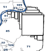
If I take the Plum area as an example it can be covered by 12 rectangles but depending of how accurate it needs to be it can probably be done using much less number of rectangles. It's only 6-7 miles across the whole Plum area. Sites can probably be set by using a big single, or 2 or 3, rectangles to not spend time constantly unloading and then immediately load the same sites again when traveling between rectangles, and then have one of the smaller 12 rectangles set to each department of TG's or even conventional frequencies if needed. If you add 0.2 mile in the scanners range setting it will give time to load a new area and for rectangle drawing imperfections before unloading the old area from the scan cycle. I don't know the benefits of having such a small GPS area as Plum are but you probably have your reasons.


1735752560627.png

/Ubbe
 

jtwalker

Member
Premium Subscriber
Joined
Dec 3, 2012
Messages
2,174
Location
Gettysburg, PA & Fenwick Island, DE
Which is why I suggest that it would have to be something run off a PC/Linux box sending commands to the scanner. Though even rectangles, if I can draw multiple ones per system on Uniden devices, would meet my needs. My local agencies (Pittsburgh/Allegheny Co) are pretty much still all conventional UHF, so I could just set up each zone's list of frequencies as a separate system.
If you go through with the effort to break the polygon down into multiple rectangles you can effectively build any shape (well enough for the purpose of controlling a scanner). And yes, you can define multiple rectangles. These can be defined at the department and for trunked systems also for the site.
 
Top