Has anyone run into a problem with programming their scanner for gps scanning in Rockingham County in New Hampshire. The problem being on Radio Reference most if not all towns in Rockingham County are listed at a range of 22 miles. Does anyone know why they list the ranges the same for each town when in surrounding counties they list the actual range for each town? Confused listener.
You are using an out of date browser. It may not display this or other websites correctly.
You should upgrade or use an alternative browser.
You should upgrade or use an alternative browser.
GPS Scanning
- Thread starter KC1OVP
- Start date
- Status
- Not open for further replies.
Because I haven't reached New Hampshire yet. I am slowly working on correcting the ranges, most of which were imported. Stand by, they will be fixed soon.
The problem being on Radio Reference most if not all towns in Rockingham County are listed at a range of 22 miles.
@KC1OVP If your using a Uniden scanner and have created a favorites list, you can edit what is in your scanner to your liking until the db gets updated.
W1KNE, thank you, that explains everything. I didn't realize it was still a work in progress. Thank you for all the work you do for Radio Reference, it is such a valuable resource to have.
Because I haven't reached New Hampshire yet. I am slowly working on correcting the ranges, most of which were imported. Stand by, they will be fixed soon.
ve1sef
Member
I ran into this problem while setting up my 536.. There were some tower sites in NS with coordinate errors.
Used a online website to find the correct coordinates( see Youtube video by K4DPS on location based scanning
without GPS).
https://getlatlong.net/ (formerly itouchmap.com)
Used a online website to find the correct coordinates( see Youtube video by K4DPS on location based scanning
without GPS).
https://getlatlong.net/ (formerly itouchmap.com)
I ran into this problem while setting up my 536.. There were some tower sites in NS with coordinate errors.
Used a online website to find the correct coordinates( see Youtube video by K4DPS on location based scanning
without GPS).
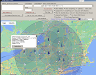
I use @ProScan software to view and edit location data in favorites lists.

ve1sef
Member
Does that use the RR database or an independent source?
Does that use the RR database or an independent source?
If your referring to what I posted, it will use whatever is in your favorites list as that is where it is getting the data to display on the map. So if you downloaded from the db and had not made any changes, it would be using that data.
Using that tool in @ProScan lets you not only see the ranges that were imported from the db, but it also lets you edit them. Then just write back to your scanner.
Do you know if you enter the Town, State, and zip code will it give you the center of the towns lat & lon on the itouchmap website?I ran into this problem while setting up my 536.. There were some tower sites in NS with coordinate errors.
Used a online website to find the correct coordinates( see Youtube video by K4DPS on location based scanning
without GPS).
https://getlatlong.net/ (formerly itouchmap.com)
ve1sef
Member
Yes. Zip code (postal code in Canada) is optional I've also looked up some airports also using the "call sign"Do you know if you enter the Town, State, and zip code will it give you the center of the towns lat & lon on the itouchmap website?
i.e. YHZ for Halifax International.
I don't really use the coordinates in the the database as most or all are greatly exaggerated for my use.
I will use google earth pro to get the basic coordinates to enter using Proscan, enter them then, and use the google maps button located next to where you enter the data to fine tune the area I want to cover.
I have also found using the rectangle option better for determining the coverage area over using the circle option.
You can make many small rectangles vs only one large circle.
Overlapping of large circles may cause you to hear more than you want to.
- Status
- Not open for further replies.
Similar threads
- Replies
- 5
- Views
- 469
- Replies
- 5
- Views
- 478
- Replies
- 1
- Views
- 409
- Replies
- 3
- Views
- 587

