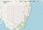
I just wanted to share this online map I made that lets you plot the common 6 digit grid reference locations you might hear used by the New South Wales (Australia) Rural Fire Service.
 bitsinaction.github.io

Rural Fire Service Grid Reference Map Plotter - Plot a 6 digit grid reference on a map. RFS Grid Reference Map Plotter
An RFS 6 digit grid reference, is a fast and simplified way of communicating locations within a known operations area of 100kmx100km.
This simplification involves removing the unnecessary details (to the local operation) of accuracy and the broader location.
When mapping a 6 digit grid reference the specific 100x100km area it applies to is not know from just the 6 digits. Therefore we map all possibilities (for each blue grid), and you must work out which one is the most likely due to the location the report came from.
One way to get a 6 digit reference: start with a full UTM grid reference off a map and: For the Easting, take the 2nd,3rd & 4th digits, and for the Northing take the 3rd, 4th & 5th digits.
GitHub Project Page: bitsinaction/RFS_Grid_Ref_Map
Thanks to Javier Jimenez Shaw, for his library:
Simple UTM (WGS84) methods for L.LatLng: jjimenezshaw/Leaflet.UTM
More Details:
 nswrfs.atlassian.net
 www.maptools.com
Rural Fire Service (RFS) Grid Reference Map Plotter
 bitsinaction.github.io

Rural Fire Service Grid Reference Map Plotter - Plot a 6 digit grid reference on a map. RFS Grid Reference Map Plotter
An RFS 6 digit grid reference, is a fast and simplified way of communicating locations within a known operations area of 100kmx100km.
This simplification involves removing the unnecessary details (to the local operation) of accuracy and the broader location.
When mapping a 6 digit grid reference the specific 100x100km area it applies to is not know from just the 6 digits. Therefore we map all possibilities (for each blue grid), and you must work out which one is the most likely due to the location the report came from.
One way to get a 6 digit reference: start with a full UTM grid reference off a map and: For the Easting, take the 2nd,3rd & 4th digits, and for the Northing take the 3rd, 4th & 5th digits.
GitHub Project Page: bitsinaction/RFS_Grid_Ref_Map
Thanks to Javier Jimenez Shaw, for his library:
Simple UTM (WGS84) methods for L.LatLng: jjimenezshaw/Leaflet.UTM
More Details:
Reading a Map - Technical Level - Confluence
More details about UTM grid zones
MapTools - Tools and instructions for GPS users to work with UTM, MGRS and lat/lon coordinate systems.
 www.maptools.com

