TROPICAL WEATHER OUTLOOK
(systems to watch in the lower latitudes in and near North America)
The key to forecasting the eventual landfall of Hurricane Rita is by looking at what is steering the growing storm. Since Rita is a full-blown synoptic scale hurricane, with an imprint visible even on 200MB charts, longwave features such as upper atmospheric ridges and troughs will serve as a guide to the motion of the storm. The system in question is a very strong heat ridge stretching from TX and OK into GA and SC. The lower level portion of the anticyclone shifts to the Carolinas by 72 hours, while the 500MB signature retrogresses to NM. This creates an opening or weakness for Rita to move northward on Friday, allowing a change from a westward heading to northwest, into TX.
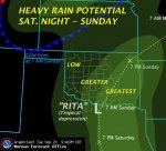
The exact point of impact is somewhat problematical, since the range of model solutions runs roughly from Port Arthur to Brownsville in the Lone Star State. A lot would have to happen to the heat ridge for an E TX strike (namely, complete collapse of the anticyclone after the core reaches W NC), so the middle cluster of solutions would probably work best, from Corpus Christi to Galveston. I will pick Freeport for convenience, which is not at all an ideal solution for the Houston metro area. Since Rita has a large envelope of circulation, and should expand its area of convection much like Katrina did two weeks ago, the highly populated Galveston Bay and Houston City could be hit by steady wind speeds as high as 150mph. A major increase in strength seems likely, what with SSTs in the Gulf of Mexico beneath the eye as high as 90 deg F. The overall trajectory of Rita will slow, allowing torrential rains and spin-up tornadoes to rip up the eastern half of the state during the entire weekend.
Without a surface adjunct to "grab" the diminishing circulation, it makes sense to predict a gradual northwest-to-north recurvature into N OK by Sunday evening. If numerical model forecasts of precipitation output are correct, it is possible that some communities along and to the right of the storm track could see as much as 18 inches of rain. Like Katrina, the surge potential will be immense (a Category 5 intensity is highly possible at some point within the next 72 hours), but Galveston TX at least has better protection thanks to its seawall. This is not going to be an ideal weekend for Texans, and the idea of a second historic tropical cyclone in less than a month is not farfetched.
Prepared by Meteorologist LARRY COSGROVE on
September 21, 2005 at 3:20 A.M. ET
Copyright 2005 by Larry Cosgrove