Hey guys,
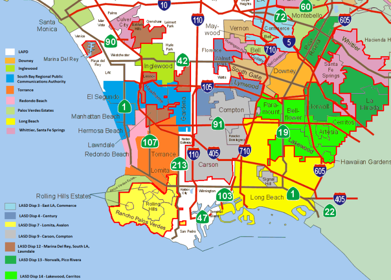
I went to visit my girlfriend near Lawndale and Manhattan Beach yesterday. I didn't know the area at all, and was curious about the jurisdictional boundaries. You can drive five minutes in that area and go between several PD channels in South Bay Regional Public Communications Authority, to Redondo Beach PD, to Torrance PD. It turned out to be none of the above, and was actually an unincorporated area patrolled by LASD South LA station on Dispatch 12.
To try and understand the area better I made a map using this map as a base and this map to identify unincorporated areas, plus all the LASD station websites to fill in the blanks. It's color coded by which law enforcement agency patrols the area. Contract cities and unincorporated areas patrolled by LASD are outlined in bright red (hard to see sorry) and color coded based on dispatch channel. LASD stations aren't included because the point of the map is simply to have a quick reference for scanner programming of what departments cover what areas.
The quality isn't great since I had to make it in MS Paint (shudder) and I'm sure there are a few errors, but I wanted to share it none the less. Hopefully you will find it to be a useful reference, because it can sometimes be difficult to locate which freqs to program from the DB alone (especially some of the LASD areas). (The original author of the base map deserves all the credit, I didn't have to do very much.)

Last edited:

