ferryboat1
Member
- Joined
- Mar 24, 2022
- Messages
- 10
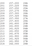
I just thought I would share with you what I know about scanning the marine band on the mighty Mississippi River of which I live on in St. Louis. All of this will reference the following link along with two screenshots of how I have the frequencies entered in my Yaesu FT-60 HT.
I've seen many threads about which marine band frequencies you should be monitoring. The answer is pretty much all of them if you are near a busy area on the Mississippi River. All of the frequencies in the link above, I scan except for CH 70, AIS1, AIS 2 and the ones marked with an "X" in the second screenshot. Some of those with an X may be used in certain areas, I am not sure but I here no activity on them. I'll go a bit further about the X channels, they are 24, 25, 26, 27, 28, 84, 85 and 86. Do notice in the link that 20 also has 2 different frequencies listed for it also and in my area the lower of the two have lots of activity hence the X on the higher one but not the lower. Both 87 and 88 are simplex and used often.
My list is by frequency and not the channel number which reveals a little bit of history about the marine band.
My advice is to either skip the ones with an X and not enter them at all or go ahead and enter them, monitor and skip them within your device if needed. In St. Louis, the action on the marine band is non stop. If your in the area, I'll give you two locations that are great. One is the casino parking lot of River City Casino or Jefferson Barracks Park, specifically on the bluff. Just look for "Scenic Circle Drive", it has a beautiful gate at the entrance with two cannons. A third area is up towards the city not too far away, Bellerive Park, which is also on a bluff along the river. Non stop radio action.
That's all I have. If you want to use my list, renumber it however you want, notice some gaps in the first column numbering. I took out CH 70 (digital only) and I had two international frequencies that should have not been in there. Marine band action is fast in this area, whatever you use, something that scans *FAST* is better. It's not like monitoring amateur radio repeaters. If you choose not to enter the X channels at all, do enter 87 & 88 which are very busy.
If you have a house nearby, I'm sure you would do well with an outdoor antenna. With an HT, you need to be right on the river as mostly the transmission lean towards low power. Just a mile from the river and my reception goes downhill with the HT. One other thing to remember that the folks you are listening to are doing a hard job in all types of weather 24 X 7 X 365, both day and night. When it's cold, windy and icy out, they continue to work. It is a dangerous job, so listen with respect.
Any additions or comments welcome, I think my list below is pretty complete and accurate.


Last edited:


