Viewing areas as it comes into saginaw bay/river with map links
West side:
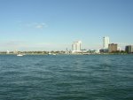
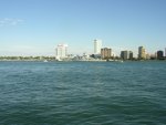
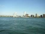
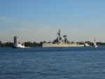
1) Bay City state park. It'll be quite viewable and long in duration clearly but maybe a couple miles off shore.
Bing Local
2) Bay city yacht club - excellent should be darn near in front of you for extended time, granted though its a club, but I was able to drive in today
Bay City Yacht Club in Bay City | Bay City Yacht Club (989) 686-1130 & 3315 Shady Shrs, Bay City, MI 48706 | <Entertainment & Arts/Bars, Pubs, & Clubs/Private Clubs> - Yahoo! US Local
3) Directly next to that on the right is the dnr public launch same very close in viewing, but many trees so it wont be visible as long.
4) Then after it passes I suggest head down to where it will eventually moor up next to independence bridge boat launch to see it get docked. Lots of parking but I'd bet that area will be the most popular viewing spot by far.
Independence Bridge - Harry Truman Parkway - Saginaw, Michigan - Moving Bridges on Waymarking.com
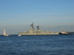
Edson will initially moor across the river and a bit east of the independence boat launch lot at the wirt stone dock as they complete the ships dock area at the final destination, independence boat launch. The lot is on marquette, has a sign at the turn in - 'future location of uss edson'. and also there is a yellow crane at the end of the dock. If you come in on independence bridge (M25) you'll see that.
East side:
Post office - Bing Maps - Driving Directions, Traffic and Road Conditions
On woodside next to the essexville post office, then next to that is the K.C. hall
You'll get to see it quite close up and moored, but probably not see as much when they are docking it I assume.
West side:
1) Bay City state park. It'll be quite viewable and long in duration clearly but maybe a couple miles off shore.
Bing Local
2) Bay city yacht club - excellent should be darn near in front of you for extended time, granted though its a club, but I was able to drive in today
Bay City Yacht Club in Bay City | Bay City Yacht Club (989) 686-1130 & 3315 Shady Shrs, Bay City, MI 48706 | <Entertainment & Arts/Bars, Pubs, & Clubs/Private Clubs> - Yahoo! US Local
3) Directly next to that on the right is the dnr public launch same very close in viewing, but many trees so it wont be visible as long.
4) Then after it passes I suggest head down to where it will eventually moor up next to independence bridge boat launch to see it get docked. Lots of parking but I'd bet that area will be the most popular viewing spot by far.
Independence Bridge - Harry Truman Parkway - Saginaw, Michigan - Moving Bridges on Waymarking.com
Edson will initially moor across the river and a bit east of the independence boat launch lot at the wirt stone dock as they complete the ships dock area at the final destination, independence boat launch. The lot is on marquette, has a sign at the turn in - 'future location of uss edson'. and also there is a yellow crane at the end of the dock. If you come in on independence bridge (M25) you'll see that.
East side:
Post office - Bing Maps - Driving Directions, Traffic and Road Conditions
On woodside next to the essexville post office, then next to that is the K.C. hall
You'll get to see it quite close up and moored, but probably not see as much when they are docking it I assume.