
You are using an out of date browser. It may not display this or other websites correctly.
You should upgrade or use an alternative browser.
You should upgrade or use an alternative browser.
VOR Transmit power??
- Thread starter kma371
- Start date
- Status
- Not open for further replies.
nycrich
Member
They can be either low, medium, High. High can be up to 1500watts. They also usually have DME (Distance Measuring Equipment) that military aircrafts use and are called VORTAC. Eg Hampton VOR off Long Island is a high power VOR. Flights coming down the Eastern seaboard and those from Europe commonly use it. Also remember that you might have skip of VHF freqs in your area also, causing long distance reception.
ATCTech
Active Member
- Joined
- Aug 13, 2002
- Messages
- 1,857
FWIW, a VORTAC is not just a VOR and a DME. A TACAN (Tactical Air Navigation) can most easily be described as the military (UHF band) version of a VOR. A stand-alone VOR usually has a DME associated with it (known as a VOR/DME site), or if it's a VORTAC site, the VOR is on it's own and the DME portion is part of the TACAN system. The TACAN can lose it's azimuth capability and still provide DME functionality to ALL DME equipped aircraft, not just military flights.
130 nautical miles is the max (advertised) range for a High VOR, but this is only at flight level altitudes (FL180-450 for the few dc-9s who still actually use VORs that high). From 1000 ft-AGL to 14,500 feet they have the same range as low class VOR's...40 nm. No usable signal reliable for navigation is ensured below 1000 ft AGL.
FWIW, it obviously does have a higher power output, however the "High" "low" and "terminal" classes of VOR's are used to identify the altitude class of the station, not the power level. Further, there is no standard power setting for many VORs. Terminal VOR's power levels, for example, are adjusted for environmental variables such as terrain and elevation to only provide a signal in the allowed range of 25 nm and are generally unusable above 12000 ft. These Terminal stations are typically only used for non-precision approaches at the field and limiting the range/power allows for greater utilization of NAVAID frequencies so that multiple nav signals dont interfere with each other over distance.
FWIW, it obviously does have a higher power output, however the "High" "low" and "terminal" classes of VOR's are used to identify the altitude class of the station, not the power level. Further, there is no standard power setting for many VORs. Terminal VOR's power levels, for example, are adjusted for environmental variables such as terrain and elevation to only provide a signal in the allowed range of 25 nm and are generally unusable above 12000 ft. These Terminal stations are typically only used for non-precision approaches at the field and limiting the range/power allows for greater utilization of NAVAID frequencies so that multiple nav signals dont interfere with each other over distance.
Last edited:
In Canada, VOR's are 150W CW VHF.
VORTAC's have the same VOR power, but also have a TACAN (UHF VOR for Military use only + DME for civilian use) rated at 5.2 KW peak power
VORDME's have the same VOR power, but have a standalone DME. Depending on location and intended use, the DME can have 100W (approach) or 1000W (en route)
Cheers!
Ohh...and usually, the antenna's are about 30 feet off the ground for VOR's, and 50 feet for DME's. Again, Canadian Standards.
JStemann
Member
About the same here...
VOR power is set around 100-120 watts normally. Exact power is based on coverage requirements and is determined by a flight inspection aircraft at installation. The max output is 200w. All of the ones I've worked with were in the 100-130w range.
jeff
VOR power is set around 100-120 watts normally. Exact power is based on coverage requirements and is determined by a flight inspection aircraft at installation. The max output is 200w. All of the ones I've worked with were in the 100-130w range.
jeff
Hey, Jeff and Lowa. as vor techs could you shed some light on the Cowboy and Maverick VOR's in Dallas. CVE and TTT i think. what is with them being built to look like UFO landing pads. the surrounding terrain does not appear to be bad enough to justify such enormous structures. Is it just because they are in Texas and they have the space to waste or is that design really necessary?
I don't know why they would have such a mammoth structure for a VOR. The one thing I did notice is that it is a Doppler VOR, which usually means that there is rough terrain around, or they had issues achieving minimum coverage during flight calibration. They could have also done it simply to improve range (both of those VOR's are about 25nm away from the threshold).

this is a typial Standard VOR (standard VORTAC) Notice there are only 16 outside antenna (monitoring only, no transmit) and the above picture has approx 50 (and they transmit, on a doppler VOR) if i recall FAA spec VOR's correctly.
Another reason could be non electronic/range related at all, it could simply be built like that so that vandals cannot get on top of the structure, or inside the shelter to damage and steal expensive electronic equipment. We have mountain top doppler VOR's where the shelters are completely underground, and the VOR antenna's are mounted in the ground. No counterpoise at all.
Maybe the other guy has more to add...but that's all I have to say.
JStemann
Member
Interstate nearby?
Maybe some other type of heavy(volume) ground traffic nearby. That's about the only other reason I can think of for the elevated counterpoise.
jeff
Maybe some other type of heavy(volume) ground traffic nearby. That's about the only other reason I can think of for the elevated counterpoise.
jeff
oneirish
Member
- Joined
- Jul 9, 2008
- Messages
- 33
Or..
Maybe they just wanted to scare the hell out of the field mice. Notice you don't see any lurking around with the typical field mice arrogant smirks in the top photo. Success!
Whereas the human in the bottom photo is clearly unafraid and even took a nice photo. He may even re-visit or move in with his family.
Last edited:
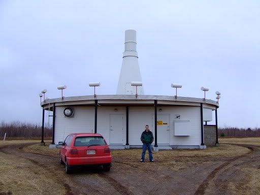
The first picture is an elevated, extended counterpoise Doppler VOR. An elevated, extended counterpoise is used to eliminate the local effect of terrain or other obstructions on the formation of the VOR signal. Some Doppler VORs use a conventional height and sized counterpoise like in the second picture except the 16 monitor antennas are replaced with 50 sideband antenna like in the first picture. The 50 Alford loop antennas are controlled as diagonally opposite pairs and are used to generate the 9960 Hz reference signal. They are switched on and off, sequentially, one pair at a time, and because the pattern rotates around the counterpoise, the Doppler effect is generated which frequency modulates the 9960 Hz. Because the 9960 Hz is radiated from a wide aperture, the terrain effect is minimized. The tower to the right of the Doppler VOR is the monitor antenna used to measure real time signal quality.
The second picture is a conventional VOR. All of the VOR signal including the 9960 Hz reference is radiated by 4 Alford loop antennas mounted inside of the teepee.
The second picture is a conventional VOR. All of the VOR signal including the 9960 Hz reference is radiated by 4 Alford loop antennas mounted inside of the teepee.
The first picture is an elevated, extended counterpoise Doppler VOR. An elevated, extended counterpoise is used to eliminate the local effect of terrain or other obstructions on the formation of the VOR signal. Some Doppler VORs use a conventional height and sized counterpoise like in the second picture except the 16 monitor antennas are replaced with 50 sideband antenna like in the first picture. The 50 Alford loop antennas are controlled as diagonally opposite pairs and are used to generate the 9960 Hz reference signal. They are switched on and off, sequentially, one pair at a time, and because the pattern rotates around the counterpoise, the Doppler effect is generated which frequency modulates the 9960 Hz. Because the 9960 Hz is radiated from a wide aperture, the terrain effect is minimized. The tower to the right of the Doppler VOR is the monitor antenna used to measure real time signal quality.
The second picture is a conventional VOR. All of the VOR signal including the 9960 Hz reference is radiated by 4 Alford loop antennas mounted inside of the teepee.
I was wondering when you were going to chime in ;-) I recently cut a set of new LOC cables, the twin tee type where the power divider doesn't accommodate for equal length feelines. Man that was fun. 10 different pairs of phased LDF4-50.
I hear the cables for the doppler's are just as much fun to make ;-)
How are things? You can PM me if you want.
Additionally, the sheer size of the structure is needed to support the recreated ground plane as you can see here:An elevated, extended counterpoise is used to eliminate the local effect of terrain or other obstructions on the formation of the VOR signal.
http://maps.google.com/maps?ll=32.868932,-97.040385&z=18&t=h&hl=en
I suppose you could say that it is impressive by way of a functional design.
overkill?
Right, I assumed that would be the technical reason for the elevation of the site. My question was more asking is the excessive height and ground plane big enough to play baseball on REALLY necessary? I have spent way too much time at way too many airports and these two VOR's are the ONLY ones I can recall looking that exotic(they didnt build Northbrook to clear the Sears Tower) ....coincidence they are in the same city? .....The Dallas area is hardly a hotbed of terrain or other obstructions when compared to many other Metro airports with associated NavAids.
So, is this just another case of "it just has to be bigger cus its in Hell"...oops, I mean Texas?
The first picture is an elevated, extended counterpoise Doppler VOR. An elevated, extended counterpoise is used to eliminate the local effect of terrain or other obstructions on the formation of the VOR signal.
Right, I assumed that would be the technical reason for the elevation of the site. My question was more asking is the excessive height and ground plane big enough to play baseball on REALLY necessary? I have spent way too much time at way too many airports and these two VOR's are the ONLY ones I can recall looking that exotic(they didnt build Northbrook to clear the Sears Tower) ....coincidence they are in the same city? .....The Dallas area is hardly a hotbed of terrain or other obstructions when compared to many other Metro airports with associated NavAids.
So, is this just another case of "it just has to be bigger cus its in Hell"...oops, I mean Texas?
If you look at the picture on google, there's a freeway on both sides of it. I've been in situations where parking a pickup truck besides a VOR made it fail. The monitors are extremely sensitive to any reflections at all. Being so high, and so large of a counterpoise, recreates the ground plane, and isolates reflections from large trucks (tractor trailers) ect...
And believe me, we don't do anything in aviation just because we want to, everything is meticulously planned out by dozens, if not hundreds of people. That site was probably chosen to go there for operational requirements, which needed some pretty ingenious engineering to achieve success.
As lowa2 said, as well as electronic reasons, it would be a significant deterrent to people who want to climb on top of it.
Nope.So, is this just another case of "it just has to be bigger cus its in Hell"...oops, I mean Texas?
Here is the Dolphin VOR in FL:
http://maps.google.com/maps?f=q&hl=...962,-80.349036&spn=0.001712,0.002414&t=h&z=19
Thanks for the link Crayon, very interesting. It prompted me to take a look at NKB, as the last time I drove past it (15 years ago) it was a standard looking station, surrounded by obstructions. I must eat my words as it now has new equipment that also looks like an enormous alien landing pad: http://maps.google.com/maps?f=q&hl=...311,-87.951474&spn=0.001232,0.002843&t=h&z=19
I am painfully aware we cannot do things just because we want to in this industry, if that were the case I would always be allowed 8 hours sleep before a 15 hour duty day. My experience is almost every decision is meticulously planned but driven by money. Other considerations are excluded until a set number of people are killed as a result.
I would be willing to bet they build them this way so they could update the technology and not have to change the location of the fix, which would result in the change of every airway, SID, STAR, IAP and GPS/INS Nav database that uses said fix. ....all that trouble and I didn't even think anyone actually used VOR's any more....besides North West.
And believe me, we don't do anything in aviation just because we want to, everything is meticulously planned out by dozens, if not hundreds of people.
I am painfully aware we cannot do things just because we want to in this industry, if that were the case I would always be allowed 8 hours sleep before a 15 hour duty day. My experience is almost every decision is meticulously planned but driven by money. Other considerations are excluded until a set number of people are killed as a result.
That site was probably chosen to go there for operational requirements, which needed some pretty ingenious engineering to achieve success.
I would be willing to bet they build them this way so they could update the technology and not have to change the location of the fix, which would result in the change of every airway, SID, STAR, IAP and GPS/INS Nav database that uses said fix. ....all that trouble and I didn't even think anyone actually used VOR's any more....besides North West.
Last edited:
- Status
- Not open for further replies.
Similar threads
- Replies
- 17
- Views
- 1K