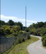
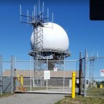
What is this?

Status
Not open for further replies.

linanbob

Member
Joined
Sep 29, 2013
Messages
14
Have a quick look at this Google maps satellite view.

This is the (former) North Truro Air Force Station on Cape Cod. The radar is an active FAA surveillance radar used by Boston Center. Note the two RCAG-looking towers immediately adjacent to it. What are these?

Per the AFF there are two RCAGS - one in Barnstable near Sandwich (41.73221248289025, -70.4879901596021) and one near the Hyannis airport (41.671892728819884, -70.2829921037513).
 

nd5y

Member
Joined
Dec 19, 2002
Messages
11,736
Location
Wichita Falls, TX
Note the two RCAG-looking towers immediately adjacent to it. What are these?
About 10 years ago I made a map of all the RCAG, AFSS RCO, and radar sites.
Several of the radar sites have one or more short towers exactly like a typical RCAG.
I think I asked what they are years ago and never got an answer.
Maybe they are for DoD and not listed anyplace.
 

linanbob

Member
Joined
Sep 29, 2013
Messages
14
About 10 years ago I made a map of all the RCAG, AFSS RCO, and radar sites.
Several of the radar sites have one or more short towers exactly like a typical RCAG.
I think I asked what they are years ago and never got an answer.
Maybe they are for DoD and not listed anyplace.
There are many current RCAGs that are located at current or former radar sites. I think it's a simple matter of availability of the real estate cheap. Some of the towers on which the radomes sit have antennas installed as well.
 

andy51edge

Member
Premium Subscriber
Joined
Apr 22, 2012
Messages
235
Location
Somewhere in North Texas
There are many current RCAGs that are located at current or former radar sites. I think it's a simple matter of availability of the real estate cheap. Some of the towers on which the radomes sit have antennas installed as well.
Is it common practice to place RCAG antennas inside VORs too? (Not adjacent to the VOR, in the VOR)
 

dispatchgeek

Control channel goes "brrrrr"
Joined
Feb 29, 2004
Messages
331
Location
Between the cornfields and the pastures, Michigan.
About 10 years ago I made a map of all the RCAG, AFSS RCO, and radar sites.
Several of the radar sites have one or more short towers exactly like a typical RCAG.
I think I asked what they are years ago and never got an answer.
Maybe they are for DoD and not listed anyplace.
I had seen a snippet some time ago about GATR sites for Milair being co-located with Joint Surveillance System Radars.
 

linanbob

Member
Joined
Sep 29, 2013
Messages
14
Is it common practice to place RCAG antennas inside VORs too? (Not adjacent to the VOR, in the VOR)

That's a really good question I have too.

What triggers my questions is I'm in the process of trying to produce an all-inclusive list of RCAGs along with accurate locations. It's based on the NASR data published by FAA every 28 days, but I'm attempting to confirm each location via Google maps satellite imagery. (NO, i will NOT be updating this monthly :) )

The locations provided in the AFF file are in some cases smack on the money, and in some cases are miles wrong. (Yes, for radio, precision in location isn't essential, but I spent a long time working in positioning applications and have become OCD over this :) ) Anyway, there are three general classes of location I've noticed:
  • An actual RCAG installation. These types of installations vary some but most consist of a square, fenced in area with one to as many as six square towers installed, each containing a number of antennas (simple white masts).
  • On the grounds of an airport but not at an actual antenna installation. These can be located smack in the middle of a runway or some other quasi-random location. It seems these denote antennas installed atop the control tower, a grid of antennas on the roof of a (typically "official") building on the airport property, a small standalone tower or something similar.
  • On or very near a VOR. The satellite imagery runs out of resolution to detect these conclusively, but it seems that for many of these there are some small number of small "pipe"-like masts with two or three antennas mounted in a line on a radial of the VOR (presumably to minimize interference). But I've seen VOR locations where I could see no such mast. I've wondered as well whether it's possible to build the antenna inside the VOR cone.
One of my fears is I'm confusing RDOs and RCAGs.

And so far as sector names... well, fuggedaboutit... I'm currently disinclined to issue FOIA requests to 22 FAA sites. I guess I'm confused why FAA would not simply publish the names, since they publish the locations of the radio sites that support them.
 

linanbob

Member
Joined
Sep 29, 2013
Messages
14
And a minor annoyance is folks who helpfully post lists of sectors or frequencies but don't add an "as of" date. These things do change.
 

nd5y

Member
Joined
Dec 19, 2002
Messages
11,736
Location
Wichita Falls, TX
What triggers my questions is I'm in the process of trying to produce an all-inclusive list of RCAGs along with accurate locations.
I did that several years ago. The FAA has a lot of bad location data. The map is FAA.zip at Aircraft - The RadioReference Wiki. I haven't updated it recently. Feel free to add/delete/fix anything and replace the file if you want to.
 

andy51edge

Member
Premium Subscriber
Joined
Apr 22, 2012
Messages
235
Location
Somewhere in North Texas
I did that several years ago. The FAA has a lot of bad location data. The map is FAA.zip at Aircraft - The RadioReference Wiki. I haven't updated it recently. Feel free to add/delete/fix anything and replace the file if you want to.
It's my hunch that because the sites are used for homeland defense, commerce and whatnot they may keep some site locations obscured to prevent sabotage.
 

nd5y

Member
Joined
Dec 19, 2002
Messages
11,736
Location
Wichita Falls, TX
It's my hunch that because the sites are used for homeland defense, commerce and whatnot they may keep some site locations obscured to prevent sabotage.
Then why don't they "hide" all of them? I think the bad locations are due to manual data entry errors, moving a site and not updating, and probably other reasons. A lot of sites are the center of airport runways or the location of the airport itself. I was never able to determine if all the sites in the Gulf of Mexico are real sites on oil rigs or other structures or bad location data.
 

ecps92

Member
Joined
Jul 8, 2002
Messages
14,901
Location
Taxachusetts
Have a quick look at this Google maps satellite view.

This is the (former) North Truro Air Force Station on Cape Cod. The radar is an active FAA surveillance radar used by Boston Center. Note the two RCAG-looking towers immediately adjacent to it. What are these?

Per the AFF there are two RCAGS - one in Barnstable near Sandwich (41.73221248289025, -70.4879901596021) and one near the Hyannis airport (41.671892728819884, -70.2829921037513).
FAA has/had an VHF FM repeater down there in the past for the Truro site
 

nd5y

Member
Joined
Dec 19, 2002
Messages
11,736
Location
Wichita Falls, TX
Wow. The govt did something smart for a change. The FAA changed some things in the 28 day subscription data. Now they have all the communications sites and frequencies in .csv files. I don't know when they added that. This is way better than messing with the old style text files.

Go to https://www.faa.gov/air_traffic/flight_info/aeronav/aero_data/NASR_Subscription/
Click the current one.
Download Communication Facilities (COM) (Zip) and Frequency Data (FRQ) (Zip)
extract the COM.csv and FRQ.csv files.

I made separate RCO and RCAG files out of COM.csv then imported it into Google Earth and changed the lable text and icon colors. Now I can easily spot the differences in my file from 2019 in the wiki.
 

MUTNAV

Active Member
Premium Subscriber
Joined
Jul 27, 2018
Messages
1,297
Looked a tthe picture in google maps, there is an old castle like tower near it ("Jenny Lind" ), if you click on it, you can see a bunch of pictures for around the tower.

Thanks
Joel
 

Attachments

  • tower.JPG
    tower.JPG
    23.7 KB · Views: 26
  • tower2.JPG
    tower2.JPG
    40.9 KB · Views: 27

dlwtrunked

Member
Premium Subscriber
Joined
Dec 19, 2002
Messages
2,382
Have a quick look at this Google maps satellite view.

This is the (former) North Truro Air Force Station on Cape Cod. The radar is an active FAA surveillance radar used by Boston Center. Note the two RCAG-looking towers immediately adjacent to it. What are these?

Per the AFF there are two RCAGS - one in Barnstable near Sandwich (41.73221248289025, -70.4879901596021) and one near the Hyannis airport (41.671892728819884, -70.2829921037513).
It is common to have NORAD radio sites at ARSR-4 radars--sometimes mounted right on the radar. Their NORAD frequencies are not in FAA publications. Note that ARSR-4, like North Truro, are generally JSS, Join Surveilance System, making them joint FAA/USAF and not just FAA. ARSR-4 are found near the nations broders with a different radar, the CARSR (FAA) radar, filling the ARSR role in the interior.
Regarding North Truro (and other ARSR radar sites), the best place to look is at:
And on the left side, go down to click on
Satellite/Topo Images
Use the right slider in the table to go down to North Truro AFS, MA (P-10, J-53) and click on it.
There you will find North Truro is now a JSS ARSR-4 site and other information. Be sure to us the right slider to go down to "The following site information is available" You can find a lot of photos of sites by going to the individual radars this way--including some of mine.
 

linanbob

Member
Joined
Sep 29, 2013
Messages
14
Then why don't they "hide" all of them? I think the bad locations are due to manual data entry errors, moving a site and not updating, and probably other reasons. A lot of sites are the center of airport runways or the location of the airport itself. I was never able to determine if all the sites in the Gulf of Mexico are real sites on oil rigs or other structures or bad location data.
IMO there are too many of them to all be bad data. I do believe (but can't prove) they're on rigs (or maybe buoys?).
 
Status
Not open for further replies.
Top