wierd antenna

Status
Not open for further replies.

BJ_NORTON

Member
Joined
Dec 19, 2002
Messages
407
Reaction score
0
Location
Las Vegas
I was out exploring today, driving around the hills above Las Vegas when I saw a strange looking pole on the side of the hill on my way home. I hadn't noticed it on my way in becasue it was quite a ways down the hill, and the only thing visible was the whip of the antenna from the road. I stoped and got out of the truck to look at it and see what it was.
0804071523.jpg


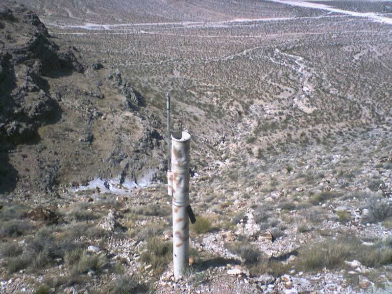
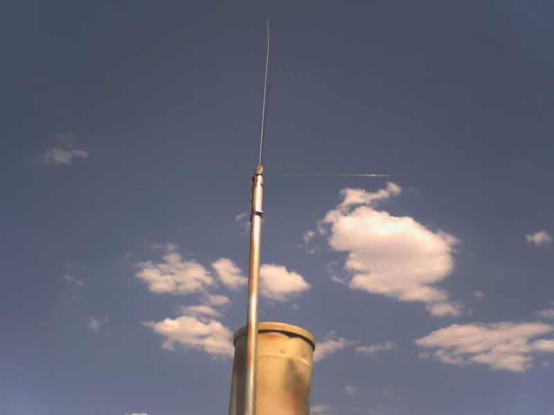
As You can see its some sort of Monopole. Its so wierd to see it out here, in the middle of nothing, on the side of a pretty steep hill. There is no way a truck or any sort of vehicle could have been much closer then about 20 feet to where it sits, and I didn't see any evidence of tracks in the dirt or plants.

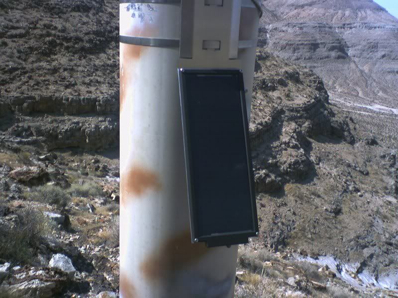
This Pole has What looks like a brand new solar panel on one side of it.
0804071524.jpg


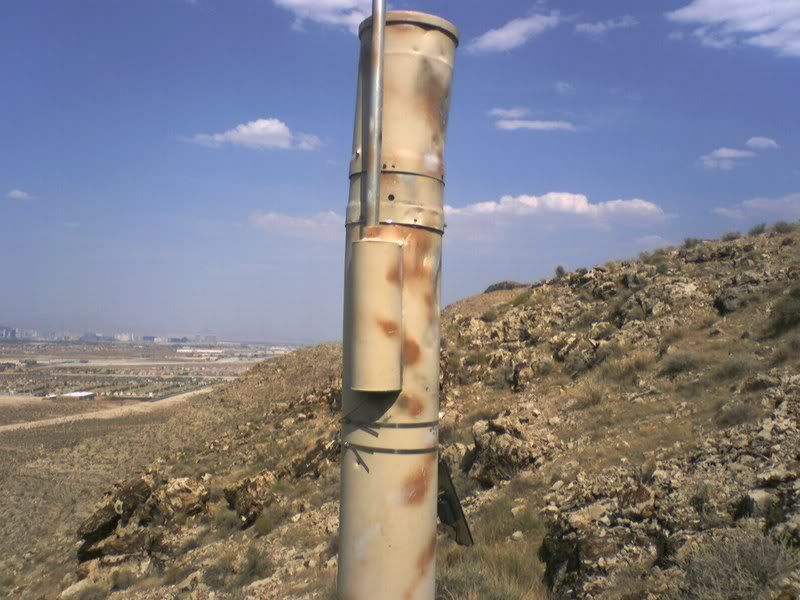
I knocked on the side of it, and the metal sounds very thin and lightweight. Also it has been painted in a camoflouge pattern-thats not rust.Its hard to see, but there are a few small caliber bullet holes in the bottom of the pole.
0804071525.jpg


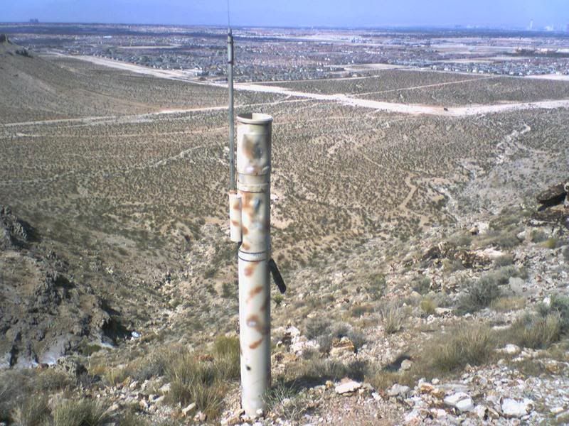
There is a bracket looking piece that has been welded onto the side and a short piece of mast has a mobile 1/4 wave whip antenna with 4 radials on it.
0804071524b.jpg

0804071524a.jpg


I had my GPS with me, and I marked the spot where I parked the truck at as 36 03.456N 115 19.354W if anyone is interested in looking it up on google earth.

I'm Wondering if anyone else has seen something like this or if you know what it might be.

Thanks!
 

BJ_NORTON

Member
Joined
Dec 19, 2002
Messages
407
Reaction score
0
Location
Las Vegas
:D :p :lol:
Very near Las Vegas. In the third and fourth pictures you can see the strip at the horizon about 15-20 miles east of where I was
:cool::cool::cool:
 

LouisvilleScanMan

Member
Premium Subscriber
Joined
Mar 22, 2006
Messages
488
Reaction score
2
Location
Louisville, KY.
Well unless Area 51 security has expanded the perimeter sensors to insane limits ( and I wouldn't put it past them) I have no idea what that antenna is for.
 

blackacid

Member
Joined
Feb 25, 2006
Messages
61
Reaction score
0
Location
Bruceton Mills, WV
This sorta looks like one of the many NOAA weather stations or rain gages. I have seen one or two of these with the same setup around where I live.

Observational data sources for this study include the National Weather Service WSR-88D Doppler Radar, GOES-7 satellite imagery, synoptic surface observations and a mesonet of hydrometeorological ALERT gages maintained by the Clark County Regional Flood Control District. The latter consists of an array of 30 automated surface weather stations which transmit real-time temperature, wind, and rainfall data every 5 minutes. The network contains an additional 61 gages which measure rainfall only.

Here is a list of the data collection points... http://breccia.ccrfcd.org/station/station2.asp
 

blackacid

Member
Joined
Feb 25, 2006
Messages
61
Reaction score
0
Location
Bruceton Mills, WV
They all have an antenna since they all transmit data to the central place for collection. You would almost have to have super vision to see the antenna in that picture though so your not blind. If you look at the rock formation on bj's solar panel pic and the formation in the 4334 pic I posted they look rather close.
 

KB9NLL

Member
Joined
Jul 13, 2007
Messages
98
Reaction score
0
Location
New London (Outagamie Co. WI) & Readfield (waupa
bezking said:
4334 has no antenna.

(or Bezking has no vision)

I don't think anybody has vision the antenna is so thin... look at BJ_NORTON's first picture theres no antenna there either but in the others you can see it... in blackacid's picture you (I) can make out the antenna's mast on the side of the pipe so i'm sure it's there.

Ours in wisconsin (menasha hwy 441 or 10 or whatever they call it now:confused: ) have wind speed on it and everything. I think it also has a directional antenna on it but then again it's a lot newer than the other one, it looks pretty old. as far as the camoflauge it doesn't look military quality I'm sure they did it so it's less intrusive or eye sore.
:cool:
 

BJ_NORTON

Member
Joined
Dec 19, 2002
Messages
407
Reaction score
0
Location
Las Vegas
I Think Blackacid is correct.

The area looks just like where I was, the view of the picture looks like it is probably taken from the a trail just lower on the hill from where I was. The hill side I was on is full of caves - one of the reasons I was up there in the first place - and I thiink they used to mine something up there ages ago. The trail I was following has a section where you can see old railroad ties, which I'm guessing was used to haul the ore out of the caves and down lower into the valley. The picture could have been taken from this rail line throughway, becasue I was on a trail about 15ft up the hill from it. the trail split off from the rail because it is much too narrow for a truck to fit on it.


Also I live just on the other side of the road from Spanish Trails and I'm 3.49miles from whereI marked this thing at:
4334Upper Flamingo 19/30/198936° 3' 29"115° 19' 20"2979 Precipitation3 miles SW of Spanish Trails

Theres no directioal antenna, because you can see there is good line of sight to the whole valley. I could bring up all of the repeaters I tried with my HT on low power-500mW.

The paint job is definantly not military, just some rust colored spray paint.

Anyway, cool to know what it is. I never would have guessed that it was 18 years old. the solar panel looks brand new, and there are only 2 or 3 bullet holes in it. there are all sorts of rusted out cars and trucks that are shot with hundreds of bullets.

Also if a GPS was off by 1 degree, that would be 15 miles, not really very useful. Mine is accurate to 15-19ft 90% of the time:lol: https://buy.garmin.com/shop/shop.do?pID=310
 

kb2vxa

Completely Banned for the Greater Good
Banned
Joined
Mar 22, 2005
Messages
6,100
Reaction score
17
Location
Point Pleasant Beach, N.J.
Hi all,

I've seen them before in Pennsylvania, looks like a standpipe to me of the sort the EPA uses to measure seepage of mine gases. Since BJ mentioned abandoned mines in the area and that area of Nevada used to have uranium mines it could be measuring radon. That came to mind knowing of similar standpipes around Centralia PA, you may have heard about the mine fire and the EPA monitoring emissions from underground. Just something that came to mind, if the site is registered someone has records, you might start with the county.
 

Don_Burke

Member
Joined
Jan 16, 2007
Messages
1,238
Reaction score
57
Location
Southeastern Virginia
BJ_NORTON said:
IAlso if a GPS was off by 1 degree, that would be 15 miles, not really very useful. Mine is accurate to 15-19ft 90% of the time:lol:

It is not unusual to have a typo of one degree in a GPS list. It would put you 60NM off if it was a degree of latitude and about 48NM off (at that latitude) if it was a degree of longitude.
 

BJ_NORTON

Member
Joined
Dec 19, 2002
Messages
407
Reaction score
0
Location
Las Vegas
kb2vxa said:
Hi all,

I've seen them before in Pennsylvania, looks like a standpipe to me of the sort the EPA uses to measure seepage of mine gases. Since BJ mentioned abandoned mines in the area and that area of Nevada used to have uranium mines it could be measuring radon. That came to mind knowing of similar standpipes around Centralia PA, you may have heard about the mine fire and the EPA monitoring emissions from underground. Just something that came to mind, if the site is registered someone has records, you might start with the county.
I believe this to be a precipitation gauge. I did a location search on the FCC webpage, and WQGT774 http://dettifoss.fcc.gov/acweb/viewer/viewframeset.jsp;jsessionid=8D0E2FF7670FDB1A62A844541CB6BAFE?__executableid=208&id=280879&connectionhandle=q7whmBpUho%2btg5MUYUgZxq1%2brbtKHLkAq7RmnwSbegyRYEMWxKR8m0pEgUAaXCZHB8MSDImIexxWt7foY7wBuIMEv18lQxjMCQCTjGYfVbM%3d&closex=false&outputname=%2fgenmen%5fa%2fdb%5f19%2fd%5fadmin%5fl%5flm.roi&saveoutput=false&outputType=ROI&serverurl=http%3a%2f%2fdettifoss%3a8088&volume=dettifoss8
seems to be the only license for 1/2 km of the coordinates I marked, and the 6th site for this license is Upper Flamingo 1 (4334), the site Black acid mentioned
 

SAR923

Active Member
Joined
Dec 19, 2002
Messages
1,514
Reaction score
2
Yep, I've seen these before in Nevada. I have a friend who works for the NWS in Reno and has installed some of them - they are precipitation monitors. I send him an e-mail about the cammo paint job and he said they just started doing that to try and make them blend in. If they don't, the local knuckleheads have tem sot up in month.
 

BJ_NORTON

Member
Joined
Dec 19, 2002
Messages
407
Reaction score
0
Location
Las Vegas
I believe that they would shoot them up too. This one is really very well camoflauged. It is set below sight from the trail. From the trail all I could see was the whip of the antenna, and only because I fixed in my mind where I saw the pipe thing. The paint they used was the exact color of the dirt all around it, and the rust made it blend in with all the plants. The outline was the only thing that caught my eye. This was the third time I was up there, and the first I had seen it.
 

kb2vxa

Completely Banned for the Greater Good
Banned
Joined
Mar 22, 2005
Messages
6,100
Reaction score
17
Location
Point Pleasant Beach, N.J.
Hi again,

That's an odd looking rain gage but I'll go with it. Camo not withstanding I see a bullet hole right below the antenna mount so it won't be long before it looks like every road sign, jackrabbit and coyote in the area. Nah, it's only for aesthetics, otherwise it's an eyesore.

BTW BJ, there are three ways of doing things, the right way, the wrong way and the Army way.
 

blackacid

Member
Joined
Feb 25, 2006
Messages
61
Reaction score
0
Location
Bruceton Mills, WV
They are odd looking gages if your not used to seeing them. Of course if you put anything out it is bound to collect bullets it seems. One of the buildings at the local repeater site knows this all to well with the 100's of bullet holes in it. Anywho, they are called tipping bucket rain gages. To give you an idea how these work....
http://www.afws.net/gage/screen1.htm
 

SAR923

Active Member
Joined
Dec 19, 2002
Messages
1,514
Reaction score
2
Correct. I've got an Oregon Scientific weather station with a minature version of the same type of tipping bucket rain gauge that transmits the data by a small UHF transmitter and antenna to the weather station display. Just a bigger scale and bigger transmitter on the NWS models.
 

MagicMan

Member
Joined
Jul 7, 2007
Messages
26
Reaction score
0
You know, after this post I started paying attention to antennas. Never paid them any mine in the past.... There are sure some smart fellows in these forums.
 
Status
Not open for further replies.
Top